International Journal of Applied Earth Observation and Geoinformation ( IF 7.6 ) Pub Date : 2020-10-06 , DOI: 10.1016/j.jag.2020.102237 Joachim Höhle
|
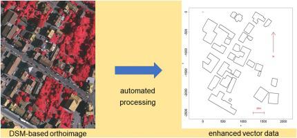
Urban areas are changing rapidly. In order to document the urban realities in topographic databases and geographic information systems efficient methods are required. Vector data of buildings are of special importance. A methodology for an automated generation of cartographically enhanced data is presented and applied to two test sites at Vaihingen, Germany. The steps of the workflow are described in detail. The examples use imagery of a large-format aerial camera to map different types of buildings. First, land cover maps are generated by means of supervised classification using two sets of attributes (basic attributes and attribute profile, basic attributes and dispersion). After the enhancement of the extracted buildings their outlines have straight, orthogonal, and parallel line segments created by least squares adjustment. The assessment of the geometric accuracy used 264 well-defined building corners and two types of references (land cover map, ortho-image). The obtained average standard deviation of the coordinates was σx,y = 1.0 m. The additional use of an attribute profile did not improve upon the geometric accuracy that was obtained by means of five attributes (height above ground, normalized difference vegetation index, standard deviation of the elevations in the 5 × 5 pixels window, intensity value of the near-infrared band, and standard deviation of intensities in the 5 × 5 surrounding at a pixel of the near-infrared band). The experiences with the developed software reveal that a graphical output of intermediate results is helpful to obtain complete and reliable results at complex building structures.
中文翻译:
通过基于DSM的正射影像分类和制图增强来自动绘制建筑物地图
城市地区变化迅速。为了在地形数据库和地理信息系统中记录城市现状,需要有效的方法。建筑物的矢量数据特别重要。介绍了一种自动生成制图增强数据的方法,并将其应用于德国Vaihingen的两个测试地点。详细描述了工作流程的步骤。这些示例使用大型航空相机的图像来绘制不同类型的建筑物。首先,使用两组属性(基本属性和属性配置文件,基本属性和散布)通过监督分类生成土地覆盖图。增强提取的建筑物后,其轮廓具有通过最小二乘平差创建的直线,正交和平行线段。几何精度的评估使用了264个定义明确的建筑拐角和两种类型的参考(土地覆盖图,正射影像)。所获得的坐标的平均标准偏差为σx ,y = 1.0 m。属性配置文件的额外使用并不能改善通过五个属性获得的几何精度(地面上的高度,归一化差异植被指数,5×5像素窗口中的标高的标准偏差,近处的强度值) -红外波段,以及在近红外波段像素周围5×5中强度的标准差)。开发软件的经验表明,中间结果的图形输出有助于在复杂的建筑结构上获得完整而可靠的结果。


 京公网安备 11010802027423号