Ecological Indicators ( IF 7.0 ) Pub Date : 2020-10-05 , DOI: 10.1016/j.ecolind.2020.106914 Purnendu Sardar , Sukha Ranjan Samadder
|
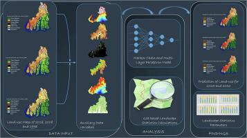
Sundarban mangrove is the largest continuous mangrove forest in the world and is the habitat of an incredible amount of biodiversity. Biodiversity loss and degradation of this highly ecologically productive mangrove forest due to climate change will have a tremendous impact on the livelihood of the people living in the deltaic region. The present study was aimed to find out the dynamics of change in different land cover for the greater Sundarban region. The multi-temporal Landsat images were used to understand the dynamics in three decades from 1998 to 2018. The analysis revealed that Sundarban mangrove forest changed very insignificantly. The change between 1998 and 2008 was approximately 1.2%, i.e. around 26.2 km2, and the change between the year 2008 and 2018 was approximately 1.27%, which consists of 28 km2. However, the dynamics of open mangrove forest and dense mangrove forest were found very high. The human habitat and aquaculture were found as the most rapidly expanding land-use type in this landscape. Area under human habitat has increased approximately 80%, i.e. nearly 654 km2 between 1998 and 2018; area under aquaculture has increased approximately 116% (i.e. around 231 km2) between 1998 and 2008. The MLP-Markov Chain based modelling of land-use has shown an overwhelming increase in human habitat in near future. However, being situated in the close vicinity of dense human population of the city Kolkata, the mangrove habitat remained intact, which is largely due to great amount of conservation efforts that have been exercised by the Govt. and the local forest department. The landscape statistical analysis for understanding the ecological dynamics of every land cover types showed that in 2018, the human habitat became second dominant category in this study area. The aquaculture practice for high economic value has pushed down the native agricultural practice in the region.
中文翻译:
使用多层感知器马尔可夫链和景观统计方法了解更大的Sundarban地区景观动态
桑达班红树林是世界上最大的连续红树林,是令人难以置信的大量生物多样性的栖息地。由于气候变化,这种高生态生产力的红树林的生物多样性丧失和退化将对生活在三角洲地区人民的生计产生巨大影响。本研究旨在找出更大的Sundarban地区不同土地覆被的变化动态。多时相Landsat影像用于了解1998年至2018年这三个十年中的动态。分析显示,桑达尔班红树林的变化很小。1998年至2008年之间的变化约为1.2%,即约26.2 km 2,而2008年至2018年之间的变化约为1.27%,包括28 km2。然而,发现开放的红树林和茂密的红树林的动态非常高。人们发现人类栖息地和水产养殖是该景观中增长最快的土地利用类型。1998年至2018年期间,人类栖息地的面积增加了约80%,即近654 km 2;水产养殖面积增加了约116%(即约231 km 2)在1998年至2008年之间。基于MLP-Markov链的土地利用模型显示,在不久的将来人类栖息地将以惊人的速度增长。但是,由于红树林栖息地位于加尔各答市人口稠密的地区附近,因此其完好无损,这在很大程度上是由于政府进行了大量的保护工作。和当地的森林部门。用于了解每种土地覆盖类型的生态动态的景观统计分析表明,2018年,人类栖息地成为该研究区域的第二大优势类别。具有高经济价值的水产养殖实践压低了该地区的本地农业实践。


 京公网安备 11010802027423号