当前位置:
X-MOL 学术
›
J. Arid Environ.
›
论文详情
Our official English website, www.x-mol.net, welcomes your
feedback! (Note: you will need to create a separate account there.)
Understanding dust sources through remote sensing: Making a case for CubeSats
Journal of Arid Environments ( IF 2.6 ) Pub Date : 2021-01-01 , DOI: 10.1016/j.jaridenv.2020.104335 Matthew C. Baddock , Robert G. Bryant , Miguel Domínguez Acosta , Thomas E. Gill
Journal of Arid Environments ( IF 2.6 ) Pub Date : 2021-01-01 , DOI: 10.1016/j.jaridenv.2020.104335 Matthew C. Baddock , Robert G. Bryant , Miguel Domínguez Acosta , Thomas E. Gill
|
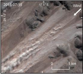
Abstract Dust sources have been revealed through remote sensing, first regionally by ~1° resolution sensors (TOMS), then at sub-basin scale by moderate-resolution sensors (MODIS). Sensors with higher spatial resolution until recently were poorly temporally-resolved, precluding their use for systematic investigations of sources. Now, “CubeSat” constellations with high-temporal-and-spatial-resolution sensors such as PlanetScope offer ~3 m resolution and daily (to sub-daily) temporal resolution. We illustrate the spatio-temporal dust plume observation capabilities of CubeSat data through a dust event case study, Bolson de los Muertos playa, Chihuahuan Desert, Mexico. For the event, PlanetScope showed numerous discrete point sources, revealing variability of surface erodibility and emission over ~8% of a focus area at time of capture. The unprecedented detail of PlanetScope imagery revealed plume development where outer-playa sands and fluvial-deltaic inputs contact lacustrine silts/clays, consistent with field-studies. PlanetScope's high fidelity improves spatial quantification and temporal constraint of source activity, and we assess the spatio-temporal capabilities of CubeSat in context with other dust observation remote sensing systems. Compared to previous satellite technologies, CubeSats bring better potential to link remote sensing to field observations of emission. This leap forward in the remote sensing of dust sources calls for the systematic analysis of CubeSat imagery in source areas.
中文翻译:

通过遥感了解尘源:为立方体卫星提供案例
摘要 沙尘源已通过遥感揭示,首先通过 ~1° 分辨率传感器 (TOMS) 在区域范围内进行,然后通过中等分辨率传感器 (MODIS) 在子流域范围内进行。直到最近,具有更高空间分辨率的传感器的时间分辨率都很差,妨碍了它们用于源的系统调查。现在,带有高时间和空间分辨率传感器(例如 PlanetScope)的“CubeSat”星座提供约 3 m 的分辨率和每日(至次每日)时间分辨率。我们通过墨西哥奇瓦瓦沙漠 Bolson de los Muertos playa 的尘埃事件案例研究说明了 CubeSat 数据的时空尘埃羽流观测能力。对于此次活动,PlanetScope 展示了许多离散点源,揭示了捕获时约 8% 的焦点区域的表面可蚀性和发射的可变性。PlanetScope 图像前所未有的细节揭示了外滩沙和河流三角洲输入接触湖相淤泥/粘土的羽流发展,与实地研究一致。PlanetScope 的高保真度提高了源活动的空间量化和时间约束,我们在其他尘埃观测遥感系统的背景下评估了 CubeSat 的时空能力。与以前的卫星技术相比,立方体卫星在将遥感与发射现场观测联系起来方面具有更大的潜力。沙尘源遥感的这一飞跃要求对源区的 CubeSat 图像进行系统分析。PlanetScope 的高保真度提高了源活动的空间量化和时间约束,我们在其他尘埃观测遥感系统的背景下评估了 CubeSat 的时空能力。与以前的卫星技术相比,立方体卫星在将遥感与现场发射观测联系起来方面具有更大的潜力。沙尘源遥感的这一飞跃要求对源区的 CubeSat 图像进行系统分析。PlanetScope 的高保真度提高了源活动的空间量化和时间约束,我们在其他尘埃观测遥感系统的背景下评估了 CubeSat 的时空能力。与以前的卫星技术相比,立方体卫星在将遥感与发射现场观测联系起来方面具有更大的潜力。沙尘源遥感的这一飞跃要求对源区的 CubeSat 图像进行系统分析。
更新日期:2021-01-01
中文翻译:
通过遥感了解尘源:为立方体卫星提供案例
摘要 沙尘源已通过遥感揭示,首先通过 ~1° 分辨率传感器 (TOMS) 在区域范围内进行,然后通过中等分辨率传感器 (MODIS) 在子流域范围内进行。直到最近,具有更高空间分辨率的传感器的时间分辨率都很差,妨碍了它们用于源的系统调查。现在,带有高时间和空间分辨率传感器(例如 PlanetScope)的“CubeSat”星座提供约 3 m 的分辨率和每日(至次每日)时间分辨率。我们通过墨西哥奇瓦瓦沙漠 Bolson de los Muertos playa 的尘埃事件案例研究说明了 CubeSat 数据的时空尘埃羽流观测能力。对于此次活动,PlanetScope 展示了许多离散点源,揭示了捕获时约 8% 的焦点区域的表面可蚀性和发射的可变性。PlanetScope 图像前所未有的细节揭示了外滩沙和河流三角洲输入接触湖相淤泥/粘土的羽流发展,与实地研究一致。PlanetScope 的高保真度提高了源活动的空间量化和时间约束,我们在其他尘埃观测遥感系统的背景下评估了 CubeSat 的时空能力。与以前的卫星技术相比,立方体卫星在将遥感与发射现场观测联系起来方面具有更大的潜力。沙尘源遥感的这一飞跃要求对源区的 CubeSat 图像进行系统分析。PlanetScope 的高保真度提高了源活动的空间量化和时间约束,我们在其他尘埃观测遥感系统的背景下评估了 CubeSat 的时空能力。与以前的卫星技术相比,立方体卫星在将遥感与现场发射观测联系起来方面具有更大的潜力。沙尘源遥感的这一飞跃要求对源区的 CubeSat 图像进行系统分析。PlanetScope 的高保真度提高了源活动的空间量化和时间约束,我们在其他尘埃观测遥感系统的背景下评估了 CubeSat 的时空能力。与以前的卫星技术相比,立方体卫星在将遥感与发射现场观测联系起来方面具有更大的潜力。沙尘源遥感的这一飞跃要求对源区的 CubeSat 图像进行系统分析。


 京公网安备 11010802027423号