当前位置:
X-MOL 学术
›
Hydrol. Process.
›
论文详情
Our official English website, www.x-mol.net, welcomes your
feedback! (Note: you will need to create a separate account there.)
On the contribution of groundwater to streamflow in laterite catchments of the Darling Range, south‐western Australia
Hydrological Processes ( IF 2.8 ) Pub Date : 2020-10-02 , DOI: 10.1002/hyp.13928 Andrew Haden Grigg 1 , Joe Kinal 2
Hydrological Processes ( IF 2.8 ) Pub Date : 2020-10-02 , DOI: 10.1002/hyp.13928 Andrew Haden Grigg 1 , Joe Kinal 2
Affiliation
|
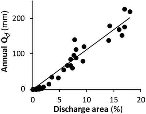
In deeply weathered laterite catchments of the Darling Range in south‐western Australia, the direct contribution (i.e., discharge) of permanent groundwater to streamflow has long been considered as minor. Instead, downslope shallow throughflow was thought to dominate, generating more than 90% of streamflow. We used a chemical hydrograph separation approach to estimate annual groundwater discharge for three catchments over periods of up to 39 years, and found that direct groundwater contributions to streamflow were far more variable across catchments and through time than has previously been acknowledged. The estimated proportion of annual streamflow sourced directly from groundwater ranged from 0 to 93% and was related linearly to the size of the groundwater discharge area in the catchment valley floor. In contrast, contributions from shallow sources including shallow throughflow varied primarily and linearly with annual rainfall. However, the response to rainfall was “amplified” in a predictable way by the size of the groundwater discharge area, consistent with the variable source area concept. We derived a functional relationship between catchment annual rainfall‐runoff ratio and groundwater discharge area and successfully applied this to a further four catchments, inferring that the results were broadly applicable across the Darling Range. The implications for an improved understanding of streamflow generating processes in the study region, and for laterite catchments generally, are discussed.
中文翻译:

澳大利亚西南部达令山脉红土流域地下水对水流的贡献
在澳大利亚西南部达令山脉深风化的红土流域,长期以来永久性地下水对水流的直接贡献(即排放)一直被认为是次要的。取而代之的是,人们认为下坡浅流占主导地位,产生了90%以上的水流。我们使用化学水位图分离方法估算了长达39年的三个集水区的年地下水排放量,发现在整个集水区和整个时间范围内,地下水对溪流的直接贡献比以前公认的要大得多。直接来自地下水的年流量的估计比例在0%到93%之间,并且与流域谷底的地下水排放区域的大小线性相关。相反,包括浅水流在内的浅水源的贡献主要与年降雨量成线性变化。然而,与可变水源面积概念相一致,地下水排放面积的大小以可预测的方式“放大”了对降雨的反应。我们推导出了集水区年降雨径流比与地下水流域之间的函数关系,并将其成功地应用于另外四个集水区,从而得出结论,该结果在整个达令岭都具有广泛的适用性。讨论了如何更好地理解研究区域内的水流产生过程以及对红土流域的意义。地下水排放面积的大小可预测地“放大”了对降雨的响应,这与可变水源面积的概念是一致的。我们推导出了集水区年降雨径流比与地下水流域之间的函数关系,并将其成功地应用于另外四个集水区,从而得出结论,该结果在整个达令岭都具有广泛的适用性。讨论了如何更好地理解研究区域内的径流产生过程以及对红土流域的意义。地下水排放面积的大小以可预测的方式“放大”了对降雨的响应,这与可变水源面积的概念一致。我们推导出了集水区年降雨径流比与地下水流域之间的函数关系,并将其成功地应用于另外四个集水区,从而得出结论,该结果在整个达令岭都具有广泛的适用性。讨论了如何更好地理解研究区域内的水流产生过程以及对红土流域的意义。推断结果在整个达令山脉均广泛适用。讨论了如何更好地理解研究区域内的水流产生过程以及对红土流域的意义。推断结果在整个达令山脉均广泛适用。讨论了如何更好地理解研究区域内的水流产生过程以及对红土流域的意义。
更新日期:2020-12-10
中文翻译:
澳大利亚西南部达令山脉红土流域地下水对水流的贡献
在澳大利亚西南部达令山脉深风化的红土流域,长期以来永久性地下水对水流的直接贡献(即排放)一直被认为是次要的。取而代之的是,人们认为下坡浅流占主导地位,产生了90%以上的水流。我们使用化学水位图分离方法估算了长达39年的三个集水区的年地下水排放量,发现在整个集水区和整个时间范围内,地下水对溪流的直接贡献比以前公认的要大得多。直接来自地下水的年流量的估计比例在0%到93%之间,并且与流域谷底的地下水排放区域的大小线性相关。相反,包括浅水流在内的浅水源的贡献主要与年降雨量成线性变化。然而,与可变水源面积概念相一致,地下水排放面积的大小以可预测的方式“放大”了对降雨的反应。我们推导出了集水区年降雨径流比与地下水流域之间的函数关系,并将其成功地应用于另外四个集水区,从而得出结论,该结果在整个达令岭都具有广泛的适用性。讨论了如何更好地理解研究区域内的水流产生过程以及对红土流域的意义。地下水排放面积的大小可预测地“放大”了对降雨的响应,这与可变水源面积的概念是一致的。我们推导出了集水区年降雨径流比与地下水流域之间的函数关系,并将其成功地应用于另外四个集水区,从而得出结论,该结果在整个达令岭都具有广泛的适用性。讨论了如何更好地理解研究区域内的径流产生过程以及对红土流域的意义。地下水排放面积的大小以可预测的方式“放大”了对降雨的响应,这与可变水源面积的概念一致。我们推导出了集水区年降雨径流比与地下水流域之间的函数关系,并将其成功地应用于另外四个集水区,从而得出结论,该结果在整个达令岭都具有广泛的适用性。讨论了如何更好地理解研究区域内的水流产生过程以及对红土流域的意义。推断结果在整个达令山脉均广泛适用。讨论了如何更好地理解研究区域内的水流产生过程以及对红土流域的意义。推断结果在整个达令山脉均广泛适用。讨论了如何更好地理解研究区域内的水流产生过程以及对红土流域的意义。


 京公网安备 11010802027423号