当前位置:
X-MOL 学术
›
Geomorphology
›
论文详情
Our official English website, www.x-mol.net, welcomes your
feedback! (Note: you will need to create a separate account there.)
Major geomorphic events and natural hazards during monsoonal precipitation 2018 in the Kali Gandaki Valley, Nepal Himalaya
Geomorphology ( IF 3.1 ) Pub Date : 2021-01-01 , DOI: 10.1016/j.geomorph.2020.107451 Rainer Bell , Monique Fort , Joachim Götz , Heidi Bernsteiner , Christoff Andermann , Jürgen Etzlstorfer , Eva Posch , Narayan Gurung , Sonam Gurung
Geomorphology ( IF 3.1 ) Pub Date : 2021-01-01 , DOI: 10.1016/j.geomorph.2020.107451 Rainer Bell , Monique Fort , Joachim Götz , Heidi Bernsteiner , Christoff Andermann , Jürgen Etzlstorfer , Eva Posch , Narayan Gurung , Sonam Gurung
|
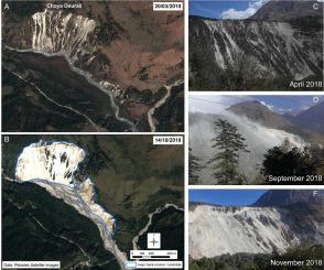
Abstract Highest geomorphic activity in the central Nepal Himalayas is mainly driven by monsoonal precipitation. In contrast, the northern flanks of the Nepal Himalaya lay in the relative dry rain shadow of the mountain range. During the monsoon 2018, major floods and geomorphic events occurred in the Kali Gandaki (KG) valley impacting both the monsoon-affected and the dry parts of the catchments. We analyze the events and its triggers based on field observations, multiple satellite image interpretation, climatological analysis using Global Precipitation Measurement and MODIS snow cover data, hydrological analysis and media analysis. The hydro-meteorological triggers are complex. Exceptional precipitation in April and May 2018 occurred in the entire study area, followed by a rather dry period. Precipitation in August was exceptional in the northern part whereas below average in the South. We argue that dynamics of snow accumulation and delayed melting contributed significantly to flooding and increased geomorphic activity in the southern part in August whereas flooding in the northern part was mainly triggered by rainfalls. We thus define 2018 as an abnormal (pre-)monsoon year with less rainfall than average but being more catastrophic. Sediment dynamics in the study area are still controlled by the Dhampu rock avalanche dam and the braided river floodplain north of this knickpoint, where sediment pulses delivered from tributaries are rarely connected from the main river. During the monsoon floods 2018 sediment connectivity was given for most tributaries due to the steepness of the catchments. The study area is subject to major human impact. Mostly in the south, numerous hillslopes have been undercut by road construction, leading to higher geomorphic sensitivity. Severe landslides might thus be triggered in future even by less intense rainfall events. Magnitude and frequency of such abnormal (pre-)monsoon precipitation are highly relevant for sediment flux and natural hazards studies.
中文翻译:

尼泊尔喜马拉雅山 Kali Gandaki 山谷 2018 年季风降水期间的主要地貌事件和自然灾害
摘要 尼泊尔喜马拉雅山脉中部的最高地貌活动主要受季风降水驱动。相比之下,尼泊尔喜马拉雅山的北侧位于山脉相对干燥的雨影中。在 2018 年季风期间,卡利甘达基 (KG) 山谷发生了重大洪水和地貌事件,影响了受季风影响的集水区和集水区的干旱地区。我们基于实地观测、多卫星图像解释、使用全球降水测量和 MODIS 积雪数据的气候分析、水文分析和媒体分析来分析事件及其触发因素。水文气象触发因素很复杂。2018 年 4 月和 5 月整个研究区出现了异常降水,随后是一段相当干旱的时期。8 月的降水在北部异常突出,而南部则低于平均水平。我们认为,积雪和延迟融化的动态对 8 月南部的洪水和地貌活动增加有显着影响,而北部的洪水主要由降雨引发。因此,我们将 2018 年定义为异常(前)季风年,降雨量低于平均水平,但更具灾难性。研究区的沉积物动力学仍受 Dhampu 岩崩大坝和该临界点以北的辫状河漫滩控制,从支流输送的沉积物脉冲很少与主河相连。在 2018 年季风洪水期间,由于集水区陡峭,大多数支流都连接了沉积物。研究区域受到重大人类影响。大部分在南部,许多山坡被道路建设削弱,导致更高的地貌敏感性。因此,即使是不太强烈的降雨事件,未来也可能引发严重的山体滑坡。这种异常(前)季风降水的幅度和频率与沉积物通量和自然灾害研究高度相关。
更新日期:2021-01-01
中文翻译:
尼泊尔喜马拉雅山 Kali Gandaki 山谷 2018 年季风降水期间的主要地貌事件和自然灾害
摘要 尼泊尔喜马拉雅山脉中部的最高地貌活动主要受季风降水驱动。相比之下,尼泊尔喜马拉雅山的北侧位于山脉相对干燥的雨影中。在 2018 年季风期间,卡利甘达基 (KG) 山谷发生了重大洪水和地貌事件,影响了受季风影响的集水区和集水区的干旱地区。我们基于实地观测、多卫星图像解释、使用全球降水测量和 MODIS 积雪数据的气候分析、水文分析和媒体分析来分析事件及其触发因素。水文气象触发因素很复杂。2018 年 4 月和 5 月整个研究区出现了异常降水,随后是一段相当干旱的时期。8 月的降水在北部异常突出,而南部则低于平均水平。我们认为,积雪和延迟融化的动态对 8 月南部的洪水和地貌活动增加有显着影响,而北部的洪水主要由降雨引发。因此,我们将 2018 年定义为异常(前)季风年,降雨量低于平均水平,但更具灾难性。研究区的沉积物动力学仍受 Dhampu 岩崩大坝和该临界点以北的辫状河漫滩控制,从支流输送的沉积物脉冲很少与主河相连。在 2018 年季风洪水期间,由于集水区陡峭,大多数支流都连接了沉积物。研究区域受到重大人类影响。大部分在南部,许多山坡被道路建设削弱,导致更高的地貌敏感性。因此,即使是不太强烈的降雨事件,未来也可能引发严重的山体滑坡。这种异常(前)季风降水的幅度和频率与沉积物通量和自然灾害研究高度相关。


 京公网安备 11010802027423号