当前位置:
X-MOL 学术
›
Int. J. Climatol.
›
论文详情
Our official English website, www.x-mol.net, welcomes your
feedback! (Note: you will need to create a separate account there.)
A near‐term drought assessment using hydrological and climate forecasting in the Mekong River Basin
International Journal of Climatology ( IF 3.5 ) Pub Date : 2020-10-01 , DOI: 10.1002/joc.6860 Hyunwoo Kang 1 , Venkataramana Sridhar 1
International Journal of Climatology ( IF 3.5 ) Pub Date : 2020-10-01 , DOI: 10.1002/joc.6860 Hyunwoo Kang 1 , Venkataramana Sridhar 1
Affiliation
|
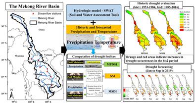
A seasonal drought forecasting approach using a high‐resolution meteorological forcing and hydrologic model was developed in the Mekong River Basin (MRB), where ground‐based observations are sparse. The Soil and Water Assessment Tool (SWAT) model was used to simulate soil moisture, runoff and evapotranspiration, which were then used to compute three drought indices for historical drought assessment (1953–2016) and seasonal forecasting of drought. In the absence of observed soil moisture data, SWAT was first calibrated with streamflow data to derive reliable soil moisture estimates, and historical drought events were validated with the available reference drought index. Based on the calibrated results, the Modified Palmer Drought Severity Index (MPDSI), Standardized Soil Moisture Index (SSI) and Multivariate Standardized Drought Index (MSDI) were estimated to evaluate the meteorological, agricultural and multivariate aspects, respectively, of drought. The total drought durations were 105–220 months, according to the reference drought index, and the estimated drought index captured 60–76% of these drought events. The three drought indices perform somewhat differently, but the 1991–1994 and 2015–2016 droughts were the worst drought events in the last 64 years based on analysis of the severity, duration and area of the meteorological and multivariate aspects of drought. The extreme droughts occurred in the Upper and Mid sections of the Lower Mekong sub‐basins and the 3S region when there were consecutive precipitation and temperature anomalies that continued for more than 2 years. Spatial variability in precipitation deficits and temperature increases were random because these variables affect soil moisture differentially. In addition, 68.4–76.1% of the areas with increased drought were explained by the areas' precipitation decrease or temperature increase. Validation of the multiple drought indices at high resolution can inform sub‐regional variability in drought conditions and hence food and water security in this important transboundary basin.
中文翻译:

利用水文和气候预报对湄公河流域进行近期干旱评估
在湄公河流域(MRB)开发了使用高分辨率气象强迫和水文模型的季节性干旱预报方法,该地区的地面观测稀疏。土壤和水评估工具(SWAT)模型用于模拟土壤水分,径流和蒸散量,然后用于计算三个干旱指数,用于历史干旱评估(1953-2016年)和干旱季节预报。在没有观测到的土壤水分数据的情况下,首先使用流量数据对SWAT进行校准,以得出可靠的土壤水分估算值,并使用可用的参考干旱指数对历史干旱事件进行验证。根据校正结果,修正的Palmer干旱严重性指数(MPDSI)估计标准土壤湿度指数(SSI)和多元标准干旱指数(MSDI)分别评估干旱的气象,农业和多元因素。根据参考干旱指数,总干旱持续时间为105-220个月,估计的干旱指数涵盖了这些干旱事件的60-76%。这三个干旱指数的表现略有不同,但根据气象干旱和多变量方面的严重程度,持续时间和面积分析,1991-1994年和2015-2016年的干旱是过去64年中最严重的干旱事件。当连续2年以上的降水和温度异常连续发生时,湄公河下游子盆地的上部和中部以及3S地区发生了极端干旱。降水量不足和温度升高的空间变异性是随机的,因为这些变量对土壤水分的影响不同。另外,干旱增加的地区中有68.4-76.1%的地区是由于降水减少或温度升高。在高分辨率下验证多个干旱指数可以为该重要跨界盆地的干旱状况提供次区域变化,从而为粮食和水安全提供依据。
更新日期:2020-10-01
中文翻译:
利用水文和气候预报对湄公河流域进行近期干旱评估
在湄公河流域(MRB)开发了使用高分辨率气象强迫和水文模型的季节性干旱预报方法,该地区的地面观测稀疏。土壤和水评估工具(SWAT)模型用于模拟土壤水分,径流和蒸散量,然后用于计算三个干旱指数,用于历史干旱评估(1953-2016年)和干旱季节预报。在没有观测到的土壤水分数据的情况下,首先使用流量数据对SWAT进行校准,以得出可靠的土壤水分估算值,并使用可用的参考干旱指数对历史干旱事件进行验证。根据校正结果,修正的Palmer干旱严重性指数(MPDSI)估计标准土壤湿度指数(SSI)和多元标准干旱指数(MSDI)分别评估干旱的气象,农业和多元因素。根据参考干旱指数,总干旱持续时间为105-220个月,估计的干旱指数涵盖了这些干旱事件的60-76%。这三个干旱指数的表现略有不同,但根据气象干旱和多变量方面的严重程度,持续时间和面积分析,1991-1994年和2015-2016年的干旱是过去64年中最严重的干旱事件。当连续2年以上的降水和温度异常连续发生时,湄公河下游子盆地的上部和中部以及3S地区发生了极端干旱。降水量不足和温度升高的空间变异性是随机的,因为这些变量对土壤水分的影响不同。另外,干旱增加的地区中有68.4-76.1%的地区是由于降水减少或温度升高。在高分辨率下验证多个干旱指数可以为该重要跨界盆地的干旱状况提供次区域变化,从而为粮食和水安全提供依据。


 京公网安备 11010802027423号