当前位置:
X-MOL 学术
›
Q. J. R. Meteorol. Soc.
›
论文详情
Our official English website, www.x-mol.net, welcomes your
feedback! (Note: you will need to create a separate account there.)
Analysis of diurnal to seasonal variability of Integrated Water Vapour in the South Indian Ocean basin using ground‐based GNSS and fifth‐generation ECMWF reanalysis (ERA5) data
Quarterly Journal of the Royal Meteorological Society ( IF 3.0 ) Pub Date : 2020-09-30 , DOI: 10.1002/qj.3915 Edouard Lees 1 , Olivier Bousquet 1 , Denis Roy 2 , Jimmy Leclair de Bellevue 1
Quarterly Journal of the Royal Meteorological Society ( IF 3.0 ) Pub Date : 2020-09-30 , DOI: 10.1002/qj.3915 Edouard Lees 1 , Olivier Bousquet 1 , Denis Roy 2 , Jimmy Leclair de Bellevue 1
Affiliation
|
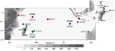
The spatial and temporal distribution of tropospheric water vapour in the South Indian Ocean (SIO) basin is investigated using observations collected from twelve GNSS stations spanning the basin. The comparison of GNSS‐derived integrated water vapour (IWV) content against radiosoundings and satellite‐borne microwave radiometer data shows good agreement, with global uncertainties ranging from 0.76 to 1.17 kg·m−2, depending on GNSS station locations. GNSS‐derived IWV contents show a strong seasonal cycle, characterized by higher water vapour content during the austral summer, when the InterTropical Convergence Zone (ITCZ) is located in the Southern Hemisphere. At the seasonal time‐scale, the observed annual IWV amplitude varies from 10 to 15 kg·m−2 near the Equator to 20 to 30 kg·m−2 in the Subtropics. The GNSS IWV signature of the Madden–Julian Oscillation (MJO) is hardly noticeable during the Austral winter, but varies from 1–2 to 4 kg·m−2 between the active and suppressed phases of the MJO during austral summer. At diurnal time‐scales, GNSS IWV shows larger diurnal amplitude over land (2–3 kg·m−2) than over open ocean (1–2 kg·m−2), with highest amplitudes (up to 7 kg·m−2) observed over large and mountainous islands. The phase analysis of the IWV diurnal cycle indicates that the diurnal maximum (minimum) is reached in the late afternoon/evening (morning) over land, at night (mid‐day) over ocean and in the early morning (late afternoon) at coastal locations. A comparison of GNSS‐derived IWV contents against fifth‐generation European Centre for Medium‐range Weather Forecasts (ECMWF) Reanalysis (ERA5) data shows that ERA5 generally correctly reproduces the IWV content at both seasonal, intra‐seasonal and diurnal time‐scales, although some discrepancies can be noticed over small islands characterised by steep orography. The signature of the MJO in ERA5 also shows good agreement with GNSS observations at most studied locations.
中文翻译:

利用地面GNSS和第五代ECMWF再分析(ERA5)数据分析南印度洋海盆综合水汽的昼夜变化
利用从横跨该盆地的十二个GNSS站收集的观测资料,对南印度洋(SIO)盆地对流层水蒸气的时空分布进行了研究。将GNSS衍生的综合水蒸气(IWV)含量与无线电探测数据和卫星传播的微波辐射计数据进行的比较显示出很好的一致性,根据GNSS站的位置,全球不确定性范围为0.76至1.17 kg · m -2。来自GNSS的IWV含量表现出强烈的季节性周期,其特征是在南方夏季,当热带交汇带(ITCZ)位于南半球时,水汽含量较高。在季节性时标上,观测到的年IWV振幅从10到15 kg · m -2不等在亚热带,赤道附近达到20至30 kg · m -2。在南半球冬季,Madden-Julian涛动(MJO)的GNSS IWV特征几乎不明显,但在南半球夏季,MJO活跃期和抑制期之间的变化范围为1-2 kg • m -2。在昼间的时间尺度,在陆地GNSS IWV显示较大的昼夜振幅(2-3公斤·米-2)比通过开放海洋(1-2公斤·米-2),具有最高振幅(最多7千克·米- 2)在大山岛上观察到。IWV昼夜周期的阶段分析表明,陆地上午后/傍晚,海洋上晚(中午)和沿海沿海清晨(午后)达到了日最大值(最小值)。位置。将GNSS衍生的IWV内容与第五代欧洲中期天气预报中心(ECMWF)重新分析(ERA5)数据进行的比较表明,ERA5通常可以在季节,季节内和昼夜时间尺度上正确再现IWV内容,尽管在地形陡峭的小岛上可能会发现一些差异。在大多数研究地点,ERA5中MJO的签名也与GNSS观测结果非常吻合。
更新日期:2020-09-30
中文翻译:
利用地面GNSS和第五代ECMWF再分析(ERA5)数据分析南印度洋海盆综合水汽的昼夜变化
利用从横跨该盆地的十二个GNSS站收集的观测资料,对南印度洋(SIO)盆地对流层水蒸气的时空分布进行了研究。将GNSS衍生的综合水蒸气(IWV)含量与无线电探测数据和卫星传播的微波辐射计数据进行的比较显示出很好的一致性,根据GNSS站的位置,全球不确定性范围为0.76至1.17 kg · m -2。来自GNSS的IWV含量表现出强烈的季节性周期,其特征是在南方夏季,当热带交汇带(ITCZ)位于南半球时,水汽含量较高。在季节性时标上,观测到的年IWV振幅从10到15 kg · m -2不等在亚热带,赤道附近达到20至30 kg · m -2。在南半球冬季,Madden-Julian涛动(MJO)的GNSS IWV特征几乎不明显,但在南半球夏季,MJO活跃期和抑制期之间的变化范围为1-2 kg • m -2。在昼间的时间尺度,在陆地GNSS IWV显示较大的昼夜振幅(2-3公斤·米-2)比通过开放海洋(1-2公斤·米-2),具有最高振幅(最多7千克·米- 2)在大山岛上观察到。IWV昼夜周期的阶段分析表明,陆地上午后/傍晚,海洋上晚(中午)和沿海沿海清晨(午后)达到了日最大值(最小值)。位置。将GNSS衍生的IWV内容与第五代欧洲中期天气预报中心(ECMWF)重新分析(ERA5)数据进行的比较表明,ERA5通常可以在季节,季节内和昼夜时间尺度上正确再现IWV内容,尽管在地形陡峭的小岛上可能会发现一些差异。在大多数研究地点,ERA5中MJO的签名也与GNSS观测结果非常吻合。


 京公网安备 11010802027423号