当前位置:
X-MOL 学术
›
Geolog. J.
›
论文详情
Our official English website, www.x-mol.net, welcomes your
feedback! (Note: you will need to create a separate account there.)
Seismic slip distribution and rupture model of the Lenglongling Fault Zone, northeastern Tibetan Plateau
Geological Journal ( IF 1.4 ) Pub Date : 2020-09-24 , DOI: 10.1002/gj.4003 Wenliang Jiang 1 , Qisong Jiao 1 , Tian Tian 1 , Jingfa Zhang 1
Geological Journal ( IF 1.4 ) Pub Date : 2020-09-24 , DOI: 10.1002/gj.4003 Wenliang Jiang 1 , Qisong Jiao 1 , Tian Tian 1 , Jingfa Zhang 1
Affiliation
|
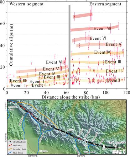
The Lenglongling Fault Zone (LLLFZ) is an important left‐lateral strike‐slip tectonic belt in the northeastern Tibetan Plateau (NETP), and the tectonic deformation and seismic activity of the LLLFZ reflect tectonic adjustments of the Qilian‐Haiyuan tectonic zone to the NETP. Although historical records of large earthquakes along the LLLFZ are not available, offset landforms reveal that large earthquakes have occurred. Therefore, offset landforms are used to study the seismic slip distribution to determine a fault slip model and earthquake recurrence behaviour based on an analysis of high‐resolution remote sensing images. Geomorphic markers associated with 316 systematically sinistrally deflected landforms were measured and analysed. The cumulative offset probability densities were analysed according to slip distributions measured along two segments of the fault. Offset density peaks in the eastern section of the fault decay exponentially with increasing offset size, suggesting that approximately seven palaeoearthquakes with an average slip of approximately 8 m occurred during the Holocene. The cumulative slips in the western segment increase gradually from west to east, with single‐event slips of approximately 2–3 m in the western part of the western segment and approximately 5–7 m in the eastern part. The seismic slip distributions of the LLLFZ indicate that the fault conforms to a quasi‐characteristic slip model. Both the eastern and western segments present typical left‐lateral strike‐slip movement. A magnitude of 8.0 was estimated for the LLLFZ palaeoearthquakes that occurred during the Holocene according to empirical relations. This study is helpful for understanding the tectonic deformation of the NETP.
中文翻译:

青藏高原东北部冷龙岭断裂带地震滑动分布与破裂模型
冷龙岭断裂带(LLLFZ)是青藏高原东北部(NETP)重要的左旋走滑构造带,LLLFZ的构造变形和地震活动反映了祁连-海原构造带向NETP的构造调整。 。尽管没有LLLFZ沿线大地震的历史记录,但偏移的地形显示大地震已经发生。因此,基于高分辨率遥感图像的分析,使用偏移地形来研究地震滑动分布,以确定断层滑动模型和地震复发行为。测量并分析了与316种系统地向左偏转的地形相关的地貌标记。根据沿着断层两个部分测得的滑动分布分析累积的偏移概率密度。断层东部断层的密度峰值随断层尺寸的增加呈指数衰减,这表明在全新世期间发生了约7次古地震,平均滑动约为8 m。西部地区的累计滑移量从西向东逐渐增加,西部地区的西部单事件滑移量约为2-3 m,东部地区的单事件滑移量约为5-7 m。LLLFZ的地震滑动分布表明该断层符合准特征滑动模型。东部和西部地区均表现出典型的左旋走滑运动。数量级为8。根据经验关系,在全新世期间发生的LLLFZ古地震估计为0。这项研究有助于理解NETP的构造变形。
更新日期:2020-09-24
中文翻译:
青藏高原东北部冷龙岭断裂带地震滑动分布与破裂模型
冷龙岭断裂带(LLLFZ)是青藏高原东北部(NETP)重要的左旋走滑构造带,LLLFZ的构造变形和地震活动反映了祁连-海原构造带向NETP的构造调整。 。尽管没有LLLFZ沿线大地震的历史记录,但偏移的地形显示大地震已经发生。因此,基于高分辨率遥感图像的分析,使用偏移地形来研究地震滑动分布,以确定断层滑动模型和地震复发行为。测量并分析了与316种系统地向左偏转的地形相关的地貌标记。根据沿着断层两个部分测得的滑动分布分析累积的偏移概率密度。断层东部断层的密度峰值随断层尺寸的增加呈指数衰减,这表明在全新世期间发生了约7次古地震,平均滑动约为8 m。西部地区的累计滑移量从西向东逐渐增加,西部地区的西部单事件滑移量约为2-3 m,东部地区的单事件滑移量约为5-7 m。LLLFZ的地震滑动分布表明该断层符合准特征滑动模型。东部和西部地区均表现出典型的左旋走滑运动。数量级为8。根据经验关系,在全新世期间发生的LLLFZ古地震估计为0。这项研究有助于理解NETP的构造变形。


 京公网安备 11010802027423号