当前位置:
X-MOL 学术
›
J. Afr. Earth Sci.
›
论文详情
Our official English website, www.x-mol.net, welcomes your
feedback! (Note: you will need to create a separate account there.)
Groundwater potential zones identification using geoelectrical sounding and remote sensing in Wadi Touil plain, Northwestern Algeria
Journal of African Earth Sciences ( IF 2.2 ) Pub Date : 2020-12-01 , DOI: 10.1016/j.jafrearsci.2020.104014 Mohand Bersi , Hakim Saibi
Journal of African Earth Sciences ( IF 2.2 ) Pub Date : 2020-12-01 , DOI: 10.1016/j.jafrearsci.2020.104014 Mohand Bersi , Hakim Saibi
|
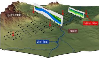
Abstract The Wadi Touil plain is situated southwest of Tiaret city; it contains two important localities, Ksar Chellala (Reibell) and Zemalet El Amir Abdelkader (Taguine). This semi-arid region belongs to the western high plains and is characterized by scarce and irregular rainfall. The lack of surface water and the agricultural activities of this region increase the demand for groundwater. Several water boreholes were installed to meet the large water needs; however, these boreholes no longer cover the high demand for water due to the increase in population, increase in irrigated areas, and wear and tear on pumps. Therefore, in order to better define the catchment area and find new sites that meet the water quality and quantity requirements, a geoelectrical survey using the electrical resistivity method was carried out in the Wadi Touil large plain South of Tiaret to investigate the electrical characteristics of sub-surface layering and evaluate the aquifer potentials. Using the Schlumberger array, a total of 127 vertical electrical soundings were conducted along 16 profiles. The recorded data were interpreted quantitatively and qualitatively through the use of isoapparent resistivity maps, geoelectrical pseudo-sections analysis, and the established geoelectric sections. The results show the presence of three very promising levels; the surface aquifer formed by the Mio-plio-Quaternary terrain (ρ = 55 Ω m), the Barremian-Albian-Aptian complex (ρ = 300 Ω m), and the Jurassic aquifer (ρ = 1200 Ω m). In this study, we determined the extent of these aquifers, their depth and their thickness. These results provide a better understanding of the geology and the deep geo-structure of the region. The remote sensing observations using Sentinel 2A images located the wet lands and provided visual evidence of the evolution of the irrigated areas over time. Finally, according to the study results, the most favorable sites for the establishment of water exploitation boreholes are proposed.
中文翻译:

阿尔及利亚西北部 Wadi Touil 平原地电探测和遥感地下水潜在区识别
摘要 Wadi Touil平原位于提亚雷特市西南;它包含两个重要的地方,Ksar Chellala (Reibell) 和 Zemalet El Amir Abdelkader (Taguine)。这个半干旱地区属于西部高平原,降雨稀少且不规则。该地区缺乏地表水和农业活动增加了对地下水的需求。安装了数个水井以满足大量的用水需求;然而,由于人口增加、灌溉面积增加以及水泵磨损,这些钻孔不再满足对水的高需求。因此,为了更好地界定集水区,寻找符合水质和水量要求的新地点,在提亚雷特以南的 Wadi Touil 大平原进行了使用电阻率方法的地电调查,以研究地下分层的电气特性并评估含水层潜力。使用 Schlumberger 阵列,沿 16 个剖面共进行了 127 次垂直电测深。通过使用等视电阻率图、地电伪剖面分析和已建立的地电剖面,对记录的数据进行了定量和定性解释。结果显示存在三个非常有希望的水平;由 Mio-plio-第四纪地形 (ρ = 55 Ω m)、Barremian-Albian-Aptian 复合体 (ρ = 300 Ω m) 和侏罗纪含水层 (ρ = 1200 Ω m) 形成的地表含水层。在这项研究中,我们确定了这些含水层的范围,它们的深度和厚度。这些结果有助于更好地了解该地区的地质和深层地质结构。使用 Sentinel 2A 图像的遥感观测定位了湿地,并提供了灌溉区域随时间演变的视觉证据。最后,根据研究结果,提出了最适宜开挖取水钻孔的地点。
更新日期:2020-12-01
中文翻译:
阿尔及利亚西北部 Wadi Touil 平原地电探测和遥感地下水潜在区识别
摘要 Wadi Touil平原位于提亚雷特市西南;它包含两个重要的地方,Ksar Chellala (Reibell) 和 Zemalet El Amir Abdelkader (Taguine)。这个半干旱地区属于西部高平原,降雨稀少且不规则。该地区缺乏地表水和农业活动增加了对地下水的需求。安装了数个水井以满足大量的用水需求;然而,由于人口增加、灌溉面积增加以及水泵磨损,这些钻孔不再满足对水的高需求。因此,为了更好地界定集水区,寻找符合水质和水量要求的新地点,在提亚雷特以南的 Wadi Touil 大平原进行了使用电阻率方法的地电调查,以研究地下分层的电气特性并评估含水层潜力。使用 Schlumberger 阵列,沿 16 个剖面共进行了 127 次垂直电测深。通过使用等视电阻率图、地电伪剖面分析和已建立的地电剖面,对记录的数据进行了定量和定性解释。结果显示存在三个非常有希望的水平;由 Mio-plio-第四纪地形 (ρ = 55 Ω m)、Barremian-Albian-Aptian 复合体 (ρ = 300 Ω m) 和侏罗纪含水层 (ρ = 1200 Ω m) 形成的地表含水层。在这项研究中,我们确定了这些含水层的范围,它们的深度和厚度。这些结果有助于更好地了解该地区的地质和深层地质结构。使用 Sentinel 2A 图像的遥感观测定位了湿地,并提供了灌溉区域随时间演变的视觉证据。最后,根据研究结果,提出了最适宜开挖取水钻孔的地点。


 京公网安备 11010802027423号