Global Environmental Change ( IF 8.6 ) Pub Date : 2020-09-23 , DOI: 10.1016/j.gloenvcha.2020.102170 Žiga Malek , Peter H. Verburg
|
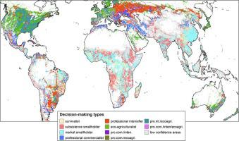
Humans have changed most of the terrestrial surface by changing land-use and land-cover. The spatial distribution and extent of land-cover changes have been studied and mapped widely, using remote sensing and geospatial technologies. Although there are numerous studies on the human decisions underlying such changes, they are limited to local case-studies. How such local-scale patterns of decision-making can be used to explain land-use change globally is unknown. Using a collection of local studies from a literature review, we studied the contextual conditions of different modes of land-use change decision-making and present global maps of the potential distribution of decision-making in land-use change. We find that decision-making in land-use can be explained, to a large extent, by the socio-economic, climatic and soil conditions of a location, captured by global data proxies of these conditions. Survival and livelihood objectives are positively associated to the spatial variation in childhood malnutrition and distance to roads, and negatively to total economic output of an area. Economic objectives on the other hand, are positively associated to total economic output, but also to the annual precipitation at the location. Similar trends are observed when looking at more detailed decision-making types: survivalist, subsistence-oriented and market-oriented smallholder decision-making types are more likely found in areas with higher poverty levels and overall lower levels of socio-economic development. The spatial distribution can be used to understand the occurrence of land-use intensification trajectories and to account for variation in decision-making in global land-use models. Finally, we provide a representation of the spread of case-studies and which contexts are poorly represented by case-studies.
中文翻译:
绘制全球土地利用决策模式
人类通过改变土地利用和土地覆盖方式改变了大部分陆地表面。利用遥感和地理空间技术,对土地覆盖变化的空间分布和范围进行了广泛研究和制图。尽管有很多关于人类做出此类变化的决策的研究,但它们仅限于本地案例研究。尚不知道如何使用这种地方尺度的决策模式来解释全球土地用途的变化。利用文献综述中的一系列本地研究,我们研究了土地利用变化决策的不同模式的环境条件,并提出了土地利用变化决策的潜在分布的全球地图。我们发现,土地使用中的决策在很大程度上可以由某个地点的社会经济,气候和土壤条件来解释,这些条件的全球数据代理捕获的数据。生存和生计目标与儿童营养不良的空间变化和到道路的距离呈正相关,与一个地区的总经济产出负相关。另一方面,经济目标与总经济产出呈正相关,而且与该地区的年降水量呈正相关。当查看更详细的决策类型时,也会观察到类似的趋势:在较贫穷的地区和整体社会经济发展水平较低的地区,更容易发现生存主义,生计导向和市场导向的小农决策类型。空间分布可用于了解土地利用集约化轨迹的发生,并解释全球土地利用模型中决策的变化。最后,


 京公网安备 11010802027423号