International Journal of Applied Earth Observation and Geoinformation ( IF 7.6 ) Pub Date : 2020-09-23 , DOI: 10.1016/j.jag.2020.102239 Zi-chen Guo , Tao Wang , Shu-lin Liu , Wen-ping Kang , Xiang Chen , Kun Feng , Xue-qin Zhang , Ying Zhi
|
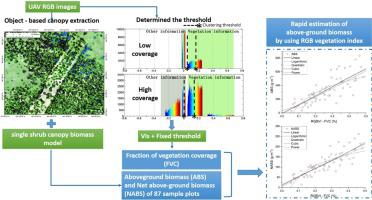
Accurate detection of vegetation cover and biomass of shrub communities in sandy area is beneficial for evaluating ecosystem, improving remote sensing models, and assessing the accuracy of remote sensing. Unmanned aerial vehicles (UAVs) have replaced traditional measurement methods in biomass and fraction of vegetation coverage (FVC) detection owing to the high spatial resolution of their imagery, their high positioning accuracy, and their ease of use. The existing methods of detecting biomass via UAVs, however, are not suitable for surface fluctuations, dwarf shrubs, and herbs. Futhermore, the method of calculating FVC using UAV RGB images has not yet been tested in sandy areas. To accurately extract FVC data, aboveground biomass (ABS) and net aboveground biomass (NABS) of shrub communities in the desert regions, UAV RGB images of 87 sample plots in the Mu Us sandy land were collected and used to obtain the FVC and biomass information via the object-based classification method, single shrub canopy biomass model and vegetation index-based method. The results are as follows: (1) the method of calculating ABS and NABS based on shrub canopy width extraction can be used in desert shrub communities, and results show that the ABS and NABS of vegetation communities increases from 15 to 800 g/m2 and 10–250 g/m2, respectively, in the Mu Us sandy land; and (2) the lowest value of ABS (NABS) appeared in the mobile sandy dunes and the highest value appeared in the semi-fixed sandy dunes; (3) under fixed thresholds conditions, the FVC can be extracted accurately using the excess green method, visible atmospherically resistant index, vegetative index, green red vegetation index and red green blue vegetation index (RGBVI); and (4) the correlation between the FVC calculated by the five RGB vegetation indexes and NABS in this study is greater than that between FVC and ABS (e.g. R2NABS - RGBVI = 0.734, R2ABS - RGBVI = 0.666), and the FVC calculated by RGBVI can be used to estimate NABS in the Mu Us sandy land. This study will provide new insights for field investigations of the ABS, NABS, and FVC in sandy areas.
中文翻译:
Mu Us沙地的生物量和植被覆盖度调查-基于无人机RGB图像
准确检测沙地灌木群落的植被覆盖度和生物量,有利于评估生态系统,改进遥感模型和评估遥感的准确性。由于图像的高空间分辨率,高定位精度和易用性,无人飞行器(UAV)替代了生物量和植被覆盖率(FVC)检测中的传统测量方法。但是,通过无人机检测生物量的现有方法不适用于表面起伏,矮灌木和草药。此外,尚未在沙质地区测试使用UAV RGB图像计算FVC的方法。为了准确提取FVC数据,沙漠地区灌木群落的地上生物量(ABS)和地上净生物量(NABS),通过基于对象的分类方法,单灌木冠层生物量模型和基于植被指数的方法,收集了毛乌斯沙地87个样地的UAV RGB图像,并用于获取FVC和生物量信息。研究结果如下:(1)基于灌木冠层宽度提取的ABS和NABS计算方法可用于沙漠灌木群落,结果表明植被群落的ABS和NABS从15 g / m增加到800 g / m。Mu Us沙地分别为2和10–250 g / m 2;(2)流动沙丘中的ABS(NABS)最低,半固定沙丘中的ABS最高。(3)在固定阈值条件下,可采用过量绿色法,可见大气阻力指数,营养指数,绿红植被指数和红绿蓝植被指数(RGBVI)准确提取FVC;(4)在这项研究中,由五个RGB植被指数计算的FVC与NABS之间的相关性大于FVC与ABS之间的相关性(例如R 2 NABS-RGBVI = 0.734,R 2 ABS-RGBVI= 0.666),并且RGBVI计算的FVC可用于估算Mu Us沙地中的NABS。这项研究将为沙质地区的ABS,NABS和FVC的现场调查提供新的见解。


 京公网安备 11010802027423号