Progress in Earth and Planetary Science ( IF 3.5 ) Pub Date : 2020-09-23 , DOI: 10.1186/s40645-020-00365-9 Ryosuke Fujita , Kazuhisa Goto , Yasufumi Iryu , Tomoya Abe
|
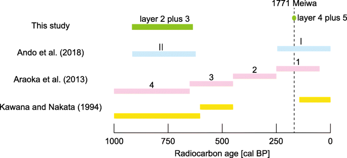
Huge tsunami waves have repeatedly bombarded the southern end of the Ryukyu Islands (Miyako and Yaeyama Islands, southwestern Japan) at several-hundred-year intervals. Therefore, clarifying the islands’ paleotsunami history is important for risk assessment. Nevertheless, discrepancies of paleotsunami histories exist among regional studies of tsunami boulders and sandy tsunami deposits. Radiocarbon ages of tsunami boulders indicate that tsunami events of the last 2400 years have occurred every 150–400 years, most recently the historical 1771 Meiwa tsunami. Sandy tsunami deposits at Yaeyama Islands show that four tsunami events of the last 2000 years struck the islands at approximately 600-year intervals. Sandy tsunami deposits of the Miyako Islands have been studied only rarely. Therefore, studying sandy tsunami deposits in the Miyako Islands is crucially important for clarifying the paleotsunami history of this region. We conducted a trench survey on Minna Island, located among the westernmost Miyako Islands, which revealed two sandy tsunami deposits under a coral tsunami boulder transported by the 1771 tsunami. The upper tsunami deposit was likely deposited by the 1771 tsunami, as inferred from stratigraphic correlation to the tsunami boulder. However, the lower tsunami deposit was probably deposited 700–1000 years ago, which is consistent with the age range of the paleotsunami reported for Yaeyama Islands. Because sandy tsunami deposits found in this and earlier studies are thick and deposited at high elevation and far inland, these are useful markers of large tsunami events similar to the 1771 event. However, the reported tsunami boulders of various sizes are deposited along the coast and reefs: they can be formed not only by large tsunami events but also by small ones. It is noteworthy that each tsunami deposit is coarse and thick (40–48 cm) relative to the island elevation (about 12 m maximum, 7 m above the mean sea level at the study site). By assuming that tsunamis have affected this region repeatedly during the past few thousand years at around 600-year intervals, tsunamis might have been important geomorphic agents for building up small reef-surrounded islands such as Minna Island.
中文翻译:
日本琉球群岛南部明娜岛的千年古海啸历史
巨大的海啸以数百年的间隔反复轰炸琉球群岛的南端(宫古岛和八重山群岛,日本西南部)。因此,弄清这些岛屿的古海啸历史对于风险评估很重要。然而,在海啸巨石和沙质海啸沉积物的区域研究中,古海啸的历史存在差异。海啸巨石的放射性碳年龄表明,过去2400年的海啸事件每150-400年发生一次,最近一次是历史性的1771年明和海啸。八重山群岛的沙质海啸沉积物表明,过去2000年中有四次海啸袭击了这些岛屿,间隔约为600年。宫古群岛的沙质海啸沉积物很少被研究。因此,研究宫古群岛的沙质海啸沉积物对于弄清该地区的古海啸历史至关重要。我们对位于最西端的宫古群岛之间的明纳岛进行了海沟调查,结果发现1771年海啸运送的珊瑚海啸巨石下有两个沙质海啸矿床。从海啸巨石的地层相关性推断,上海啸沉积物可能是1771年海啸造成的。然而,较低的海啸沉积物可能是在700-1000年前沉积的,这与八重山群岛报道的古海啸的年龄范围一致。由于在此研究和早期研究中发现的沙质海啸沉积物很厚,并且沉积在高海拔和遥远的内陆,因此这些是类似于1771年事件的大型海啸事件的有用标志。然而,据报道,各种大小的海啸巨石都分布在海岸和礁石上:它们不仅可以由大型海啸事件形成,也可以由小型海啸事件形成。值得注意的是,相对于岛屿海拔(每个海啸最大沉积物约12 m,比研究地点的平均海平面高7 m),每个海啸沉积物都较粗且较厚(40-48 cm)。通过假定海啸在过去几千年中以大约600年的时间间隔反复影响着该地区,海啸可能已经成为重要的地貌代理,以建造围绕礁石的小岛,例如明纳岛。值得注意的是,相对于岛屿海拔(每个海啸最大沉积物约12 m,比研究地点的平均海平面高7 m),每个海啸沉积物都较粗且较厚(40-48 cm)。通过假定海啸在过去几千年中以大约600年的时间间隔反复影响着该地区,海啸可能已经成为重要的地貌代理,以建造围绕礁石的小岛,例如明纳岛。值得注意的是,相对于岛屿海拔(每个海啸最大沉积物约12 m,比研究地点的平均海平面高7 m),每个海啸沉积物都较粗且较厚(40-48 cm)。通过假定海啸在过去几千年中以大约600年的时间间隔反复影响着该地区,海啸可能已经成为重要的地貌代理,以建造围绕礁石的小岛,例如明纳岛。


 京公网安备 11010802027423号