当前位置:
X-MOL 学术
›
Earth Planets Space
›
论文详情
Our official English website, www.x-mol.net, welcomes your
feedback! (Note: you will need to create a separate account there.)
Surface displacement revealed by L-band InSAR analysis in the Mayya area, Central Yakutia, underlain by continuous permafrost
Earth, Planets and Space ( IF 3.0 ) Pub Date : 2020-09-22 , DOI: 10.1186/s40623-020-01266-3 Takahiro Abe , Go Iwahana , Petr V. Efremov , Alexey R. Desyatkin , Takumi Kawamura , Alexander Fedorov , Yuri Zhegusov , Kazuki Yanagiya , Takeo Tadono
Earth, Planets and Space ( IF 3.0 ) Pub Date : 2020-09-22 , DOI: 10.1186/s40623-020-01266-3 Takahiro Abe , Go Iwahana , Petr V. Efremov , Alexey R. Desyatkin , Takumi Kawamura , Alexander Fedorov , Yuri Zhegusov , Kazuki Yanagiya , Takeo Tadono
|
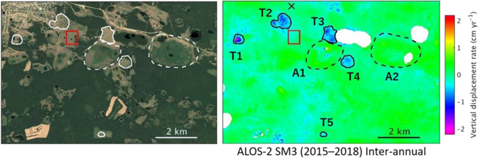
Recent increases in global temperature have stimulated permafrost degradation associated with landform deformation caused by the melting of excess ground ice (thermokarst). Central Yakutia is underlain by ice-rich continuous permafrost, and there are complicated permafrost-related features in forested and deforested areas. This situation makes thermokarst monitoring necessary over a wide area to achieve a better understanding of its dynamics. As a case study, we applied L-band InSAR analysis to map surface subsidence due to thermokarst in this area and to demonstrate the suitability of L-band SAR for such monitoring. Our results show that InSAR detected subsidence/uplift signals in deforested areas and alasses; whereas, there were few ground deformation signals in forested areas with middle coherence. The InSAR stacking process, including both seasonal and inter-annual displacements, showed subsidence in deforested areas during 2007–2010 and 2015–2018, in the range of 0.5–3 cm yr −1 . We also estimated the inter-annual subsidence to be up to 2 cm yr −1 during 2015–2018, using InSAR pairs that spanned the same seasonal interval but in different years. The magnitude of subsidence and the spatial patterns are qualitatively reasonable as thermokarst subsidence compared to observations using field surveys and high-resolution optical images. L-band InSAR was effective in maintaining coherence over a long period for a partially forested thermokarst-affected area, which resulted in deriving the inter-annual subsidence by the stacking using four interferograms. The advantage of the persistent coherence in L-band InSAR is crucial to better understand thermokarst processes in permafrost regions.
中文翻译:

L 波段 InSAR 分析揭示了位于雅库特中部 Mayya 地区的地表位移,其下方为连续多年冻土
最近全球温度的升高刺激了与地貌变形相关的永久冻土退化,这些变形是由过量地冰(热喀斯特)融化引起的。雅库特中部下方是富含冰的连续多年冻土,森林和森林砍伐地区具有复杂的多年冻土相关特征。这种情况使得有必要在大范围内进行热岩溶监测,以更好地了解其动态。作为一个案例研究,我们应用 L 波段 InSAR 分析来绘制该地区由热岩溶引起的地表沉降,并证明 L 波段 SAR 对此类监测的适用性。我们的结果表明,InSAR 检测到森林砍伐地区和森林的沉降/隆起信号;而在中等相干性的林区几乎没有地面变形信号。InSAR叠加过程,包括季节性和年际位移在内,在 2007-2010 年和 2015-2018 年期间,森林砍伐地区的沉降范围为 0.5-3 cm yr -1 。我们还使用跨越相同季节间隔但在不同年份的 InSAR 对估计 2015-2018 年间的年间沉降高达 2 cm yr -1。与使用实地调查和高分辨率光学图像的观测相比,下沉的幅度和空间模式在定性上是合理的,因为热岩溶下沉。L 波段 InSAR 可以有效地长期保持部分森林热岩溶影响区域的相干性,从而通过使用四个干涉图的叠加得出年际沉降。
更新日期:2020-09-22
中文翻译:
L 波段 InSAR 分析揭示了位于雅库特中部 Mayya 地区的地表位移,其下方为连续多年冻土
最近全球温度的升高刺激了与地貌变形相关的永久冻土退化,这些变形是由过量地冰(热喀斯特)融化引起的。雅库特中部下方是富含冰的连续多年冻土,森林和森林砍伐地区具有复杂的多年冻土相关特征。这种情况使得有必要在大范围内进行热岩溶监测,以更好地了解其动态。作为一个案例研究,我们应用 L 波段 InSAR 分析来绘制该地区由热岩溶引起的地表沉降,并证明 L 波段 SAR 对此类监测的适用性。我们的结果表明,InSAR 检测到森林砍伐地区和森林的沉降/隆起信号;而在中等相干性的林区几乎没有地面变形信号。InSAR叠加过程,包括季节性和年际位移在内,在 2007-2010 年和 2015-2018 年期间,森林砍伐地区的沉降范围为 0.5-3 cm yr -1 。我们还使用跨越相同季节间隔但在不同年份的 InSAR 对估计 2015-2018 年间的年间沉降高达 2 cm yr -1。与使用实地调查和高分辨率光学图像的观测相比,下沉的幅度和空间模式在定性上是合理的,因为热岩溶下沉。L 波段 InSAR 可以有效地长期保持部分森林热岩溶影响区域的相干性,从而通过使用四个干涉图的叠加得出年际沉降。


 京公网安备 11010802027423号