Progress in Earth and Planetary Science ( IF 3.5 ) Pub Date : 2020-09-21 , DOI: 10.1186/s40645-020-00363-x Takahiko Inoue , Kohsaku Arai
|
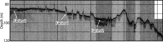
Sub-bottom profiling (SBP) surveys and bathymetric mapping conducted off the shore of Miyako-jima, which belongs to the southern Ryukyus in the Ryukyu Island Arc, have revealed the presence of mound-shaped structures 3–8 m high and 50–120 m wide at depths of 70–100 m. The SBP surveys showed that the mounds possess strong distinct, convex upward reflector shapes at the top, which we interpret as submerged reefs and reefal sediments. Additionally, modern stratified sediment layers that cover these mound-shaped structures indicate that those reefs began forming and advancing shoreward in a back-stepping fashion as a result of sea-level rise. An analysis of the mound distribution shown by SBP and multibeam echo sounding (MBES) surveys suggest that they might have been formed during the lowstand stage of sea-level change, which includes the Last Glacial Period, because the distribution of these mounds is limited to water depths of 70 to 100 m, deeper than where present-day reefs grow. The SBP images hint that such high-resolution seismic profiles, accompanied by detailed bathymetric mapping off the reefal area, have the potential to provide effective indicators of not only coral reef paleoenvironment development, but also the tectonic setting of this offshore area.
中文翻译:
日本琉球南部宫古岛岛离岛架子上水深70–100 m处的淹没式礁石和礁石碳酸盐岩的新发现
在宫古岛海岸进行的亚底轮廓(SBP)调查和测深图绘制,该岛属于琉球岛弧南部的琉球南部,发现存在3–8 m高和50–120的丘形结构深度为70–100 m的m宽。SBP调查显示,这些土丘在顶部具有强烈的,明显的,向上凸起的反射体形状,我们将其解释为淹没的礁石和礁石沉积物。此外,覆盖这些丘状结构的现代分层沉积物层表明,由于海平面上升,这些礁石开始向后退形成并向岸推进。对SBP和多波束回声测深(MBES)调查显示的土丘分布的分析表明,它们可能是在海平面变化的低潮阶段形成的,其中包括最后一个冰期,因为这些土丘的分布仅限于70至100 m的水深,比当今珊瑚礁的生长深度更深。SBP图像暗示,这样的高分辨率地震剖面,再加上详细的测深图,描绘出了该礁区,不仅有可能提供有效的指示符,不仅指示珊瑚礁古环境的发展,而且还提供该近海地区的构造环境。


 京公网安备 11010802027423号