当前位置:
X-MOL 学术
›
Remote Sens. Ecol. Conserv.
›
论文详情
Our official English website, www.x-mol.net, welcomes your
feedback! (Note: you will need to create a separate account there.)
Ultra‐high‐resolution mapping of biocrusts with Unmanned Aerial Systems
Remote Sensing in Ecology and Conservation ( IF 3.9 ) Pub Date : 2020-09-19 , DOI: 10.1002/rse2.180 Caroline A. Havrilla 1, 2 , Miguel L. Villarreal 3 , Jacob L. DiBiase 4 , Michael C. Duniway 5 , Nichole N. Barger 4
Remote Sensing in Ecology and Conservation ( IF 3.9 ) Pub Date : 2020-09-19 , DOI: 10.1002/rse2.180 Caroline A. Havrilla 1, 2 , Miguel L. Villarreal 3 , Jacob L. DiBiase 4 , Michael C. Duniway 5 , Nichole N. Barger 4
Affiliation
|
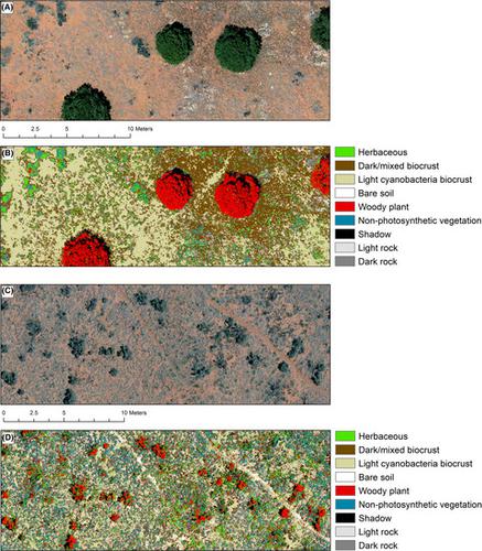
Biological soil crusts (biocrusts) occur in drylands globally where they support ecosystem functioning by increasing soil stability, reducing dust emissions and modifying soil resource availability (e.g. water, nutrients). Determining biocrust condition and extent across landscapes continues to present considerable challenges to scientists and land managers. Biocrusts grow in patches, cover vast expanses of rugged terrain and are vulnerable to physical disturbance associated with ground‐based mapping techniques. As such, remote sensing offers promising opportunities to map and monitor biocrusts. While satellite‐based remote sensing has been used to detect biocrusts at relatively large spatial scales, few studies have used high‐resolution imagery from Unmanned Aerial Systems (UAS) to map fine‐scale patterns of biocrusts. We collected sub‐centimeter, true color 3‐band imagery at 10 plots in sagebrush and pinyon‐juniper woodland communities in a semiarid ecosystem in the southwestern US and used object‐based image analysis (OBIA) to segment and classify the imagery into maps of light and dark biocrusts, bare soil, rock and various vegetation covers. We used field data to validate the classifications and assessed the spatial distribution and configuration of different classes using fragmentation metrics. Map accuracies ranged from 46 to 77% (average 65%) and were higher in pinyon‐juniper (average 70%) versus sagebrush (average 60%) plots. Biocrust classes showed generally high accuracies at both pinyon‐juniper plots (average dark crust = 70%; light crust = 80%) and sagebrush plots (average dark crust = 69%; light crust = 77%). Point cloud density, sun elevation and spectral confusion between vegetation cover explained some differences in accuracy across plots. Spatial analyses of classified maps showed that biocrust patches in pinyon‐juniper plots were generally larger, more aggregated and contiguous than in sagebrush plots. Pinyon‐juniper plots also had greater patch richness and a lower Shannon evenness index than sagebrush plots, suggesting greater soil cover heterogeneity in this plant community type.
中文翻译:

无人机对生物结皮的超高分辨率制图
生物土壤结皮(生物结皮)在全球干旱地区发生,它们通过增加土壤稳定性,减少粉尘排放和改变土壤资源(例如水,养分)来支持生态系统功能。在整个景观中确定生物结皮状况和范围仍对科学家和土地管理者提出了巨大的挑战。生物壳生长在斑块中,覆盖了广阔的崎terrain地形,并且容易受到与地面测绘技术相关的物理干扰的影响。因此,遥感提供了有希望的机会来绘制和监测生物结皮。虽然基于卫星的遥感技术已被用于在相对较大的空间尺度上探测生物结壳,但很少有研究使用无人航空系统(UAS)的高分辨率图像绘制生物结壳的精细模式。我们收集了不到一厘米 在美国西南部半干旱生态系统中的鼠尾草和针叶杜松林地社区的10个地块上的真彩色3波段图像,并使用基于对象的图像分析(OBIA)将图像分割和分类为裸露的明暗生物外壳土壤,岩石和各种植被。我们使用现场数据来验证分类,并使用碎片度量来评估不同类别的空间分布和配置。地图准确度介于46%到77%之间(平均为65%),并且在松柏(平均70%)和鼠尾草(平均60%)地块中更高。在松柏图(平均黑皮= 70%;浅皮= 80%)和鼠尾草图(平均黑皮= 69%;浅皮= 77%)上,生物皮的分类都显示出较高的精度。点云密度 太阳高程和植被覆盖物之间的光谱混乱解释了各个地块的准确性存在一些差异。分类地图的空间分析表明,与鼠尾草地块相比,松松-杜松地块中的生物地壳斑块通常更大,更聚集和连续。与鼠尾草地块相比,Pinyon-Juniper地块还具有更大的斑块丰富度和更低的Shannon均匀度指数,这表明该植物群落类型的土壤覆盖异质性更大。
更新日期:2020-09-19
中文翻译:
无人机对生物结皮的超高分辨率制图
生物土壤结皮(生物结皮)在全球干旱地区发生,它们通过增加土壤稳定性,减少粉尘排放和改变土壤资源(例如水,养分)来支持生态系统功能。在整个景观中确定生物结皮状况和范围仍对科学家和土地管理者提出了巨大的挑战。生物壳生长在斑块中,覆盖了广阔的崎terrain地形,并且容易受到与地面测绘技术相关的物理干扰的影响。因此,遥感提供了有希望的机会来绘制和监测生物结皮。虽然基于卫星的遥感技术已被用于在相对较大的空间尺度上探测生物结壳,但很少有研究使用无人航空系统(UAS)的高分辨率图像绘制生物结壳的精细模式。我们收集了不到一厘米 在美国西南部半干旱生态系统中的鼠尾草和针叶杜松林地社区的10个地块上的真彩色3波段图像,并使用基于对象的图像分析(OBIA)将图像分割和分类为裸露的明暗生物外壳土壤,岩石和各种植被。我们使用现场数据来验证分类,并使用碎片度量来评估不同类别的空间分布和配置。地图准确度介于46%到77%之间(平均为65%),并且在松柏(平均70%)和鼠尾草(平均60%)地块中更高。在松柏图(平均黑皮= 70%;浅皮= 80%)和鼠尾草图(平均黑皮= 69%;浅皮= 77%)上,生物皮的分类都显示出较高的精度。点云密度 太阳高程和植被覆盖物之间的光谱混乱解释了各个地块的准确性存在一些差异。分类地图的空间分析表明,与鼠尾草地块相比,松松-杜松地块中的生物地壳斑块通常更大,更聚集和连续。与鼠尾草地块相比,Pinyon-Juniper地块还具有更大的斑块丰富度和更低的Shannon均匀度指数,这表明该植物群落类型的土壤覆盖异质性更大。


 京公网安备 11010802027423号