当前位置:
X-MOL 学术
›
Hydrol. Process.
›
论文详情
Our official English website, www.x-mol.net, welcomes your feedback! (Note: you will need to create a separate account there.)
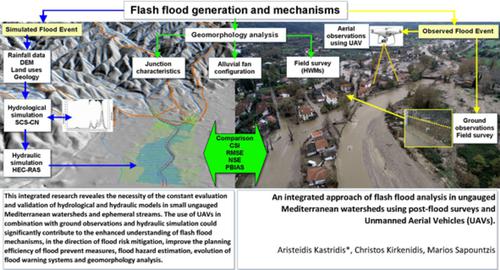
An integrated approach of flash flood analysis in ungauged Mediterranean watersheds using post‐flood surveys and unmanned aerial vehicles
Hydrological Processes ( IF 3.2 ) Pub Date : 2020-09-18 , DOI: 10.1002/hyp.13913 Aristeidis Kastridis 1 , Christos Kirkenidis 1 , Marios Sapountzis 1
Hydrological Processes ( IF 3.2 ) Pub Date : 2020-09-18 , DOI: 10.1002/hyp.13913 Aristeidis Kastridis 1 , Christos Kirkenidis 1 , Marios Sapountzis 1
Affiliation
|
This study analyzes the flash flood event of two ungauged ephemeral streams in Olympiada region (Chalkidiki, North Greece), which occurred at the 21–22 of November 2019. Aim of the study is to reconstruct the specific flash flood event, investigate the causes of flood generation mechanisms, evaluate the performance of SCS‐CN hydrological and HEC‐RAS hydraulic models, investigate the relation between extreme flash floods and human intervention, using the combination of ground and aerial observations obtained from the field survey and unmanned aerial vehicles (UAVs), respectively. The results of the specific discharge ranged between 9 and 11 m3 s−1 km2, values that are typical for flash flood events in Mediterranean region. The comparison between the observed and simulated values of flood extent showed sufficiently good performance of the hydraulic model (CSI = 82%). However, the statistical analysis of the observed and simulated flood depths displayed a flood depth overestimation by the applied model, despite that the values of the used statistic indexes are acceptable (RMSE = 0.35 m, SD = 0.53, NSE = 0.56, PBIAS = 11.26%). The model overestimation of flood depth was attributed to the DEM low resolution and quality. Ground and aerial observations depicted the alluvial fan activation, the alternation of flow paths and the huge sediment transport. Human intervention in main streams, urban sprawl, wet AMC and sediment transport were among the main factors that contributed to the flash flood generation. This integrated approach revealed the necessity of the constant evaluation and validation of hydrological and hydraulic models in small ungauged Mediterranean watersheds and ephemeral streams. The use of UAVs in combination with ground observations and hydraulic simulation could significantly contribute to the enhanced understanding of flash flood mechanisms, in the direction of flood risk mitigation, improvement of the planning efficiency of flood prevent measures, flood hazard estimation, evolution of flood warning systems and floodplain geomorphology analysis.
中文翻译:

使用洪水后调查和无人飞行器对地中海无人流域进行暴洪分析的综合方法
本研究分析了Olympiada地区(希腊北部哈尔基迪基)发生的两条未触发的短暂性暴雨事件,发生在2019年11月21-22日。该研究的目的是重建特定的暴雨事件,调查造成暴雨的原因。洪水产生机理,评估SCS-CN水文模型和HEC-RAS水力模型的性能,结合现场调查和无人飞行器(UAV)的地面和空中观测资料,研究极端暴洪与人为干预之间的关系, 分别。比放电的结果介于9和11 m 3 s -1 km 2之间,这是地中海地区山洪暴发事件的典型值。洪水程度的观测值与模拟值之间的比较表明,水力模型具有足够好的性能(CSI = 82%)。然而,尽管所使用的统计指标值是可以接受的(RMSE = 0.35 m,SD = 0.53,NSE = 0.56,PBIAS = 11.26),但对观察到的和模拟的洪水深度的统计分析显示,所应用的模型高估了洪水深度。 %)。模型对洪水深度的高估归因于DEM的分辨率低和质量差。地面和空中观测结果都表明了冲积扇的活动,流径的交替和巨大的泥沙输送。人为干预主流,城市扩张,湿AMC和泥沙输送是造成山洪泛滥的主要因素。这种综合方法表明,必须在未开垦的地中海小流域和短暂河流中不断评估和验证水文和水力模型。无人机与地面观测和水力模拟相结合的使用,可以极大地增进人们对洪水泛滥机制的认识,有助于减轻洪水风险,提高防洪措施的计划效率,评估洪灾危害,发展洪水预警系统和洪泛区地貌分析。这种综合方法表明,必须在未开垦的地中海小流域和短暂河流中不断评估和验证水文和水力模型。无人机与地面观测和水力模拟相结合的使用,可以极大地增进人们对洪水泛滥机制的认识,有助于减轻洪水风险,提高防洪措施的计划效率,评估洪灾危害,发展洪水预警系统和洪泛区地貌分析。这种综合方法表明,必须在未开垦的地中海小流域和短暂河流中不断评估和验证水文和水力模型。无人机与地面观测和水力模拟相结合的使用,可以极大地增进人们对洪水泛滥机制的认识,有助于减轻洪水风险,提高防洪措施的计划效率,评估洪灾危害,发展洪水预警系统和洪泛区地貌分析。
更新日期:2020-09-18
中文翻译:
使用洪水后调查和无人飞行器对地中海无人流域进行暴洪分析的综合方法
本研究分析了Olympiada地区(希腊北部哈尔基迪基)发生的两条未触发的短暂性暴雨事件,发生在2019年11月21-22日。该研究的目的是重建特定的暴雨事件,调查造成暴雨的原因。洪水产生机理,评估SCS-CN水文模型和HEC-RAS水力模型的性能,结合现场调查和无人飞行器(UAV)的地面和空中观测资料,研究极端暴洪与人为干预之间的关系, 分别。比放电的结果介于9和11 m 3 s -1 km 2之间,这是地中海地区山洪暴发事件的典型值。洪水程度的观测值与模拟值之间的比较表明,水力模型具有足够好的性能(CSI = 82%)。然而,尽管所使用的统计指标值是可以接受的(RMSE = 0.35 m,SD = 0.53,NSE = 0.56,PBIAS = 11.26),但对观察到的和模拟的洪水深度的统计分析显示,所应用的模型高估了洪水深度。 %)。模型对洪水深度的高估归因于DEM的分辨率低和质量差。地面和空中观测结果都表明了冲积扇的活动,流径的交替和巨大的泥沙输送。人为干预主流,城市扩张,湿AMC和泥沙输送是造成山洪泛滥的主要因素。这种综合方法表明,必须在未开垦的地中海小流域和短暂河流中不断评估和验证水文和水力模型。无人机与地面观测和水力模拟相结合的使用,可以极大地增进人们对洪水泛滥机制的认识,有助于减轻洪水风险,提高防洪措施的计划效率,评估洪灾危害,发展洪水预警系统和洪泛区地貌分析。这种综合方法表明,必须在未开垦的地中海小流域和短暂河流中不断评估和验证水文和水力模型。无人机与地面观测和水力模拟相结合的使用,可以极大地增进人们对洪水泛滥机制的认识,有助于减轻洪水风险,提高防洪措施的计划效率,评估洪灾危害,发展洪水预警系统和洪泛区地貌分析。这种综合方法表明,必须在未开垦的地中海小流域和短暂河流中不断评估和验证水文和水力模型。无人机与地面观测和水力模拟相结合的使用,可以极大地增进人们对洪水泛滥机制的认识,有助于减轻洪水风险,提高防洪措施的计划效率,评估洪灾危害,发展洪水预警系统和洪泛区地貌分析。


 京公网安备 11010802027423号