当前位置:
X-MOL 学术
›
Sediment. Geol.
›
论文详情
Our official English website, www.x-mol.net, welcomes your
feedback! (Note: you will need to create a separate account there.)
Landscape and depositional controls on palaeosols of a distributive fluvial system (Upper Cretaceous, Brazil)
Sedimentary Geology ( IF 2.7 ) Pub Date : 2020-12-01 , DOI: 10.1016/j.sedgeo.2020.105774 Marcus Vinícius Theodoro Soares , Giorgio Basilici , Paolo Lorenzoni , Luca Colombera , Nigel Philip Mountney , Agustín Guillermo Martinelli , Áquila Ferreira Mesquita , Thiago Da Silva Marinho , Richard Vásconez Garcia , André Marconato
Sedimentary Geology ( IF 2.7 ) Pub Date : 2020-12-01 , DOI: 10.1016/j.sedgeo.2020.105774 Marcus Vinícius Theodoro Soares , Giorgio Basilici , Paolo Lorenzoni , Luca Colombera , Nigel Philip Mountney , Agustín Guillermo Martinelli , Áquila Ferreira Mesquita , Thiago Da Silva Marinho , Richard Vásconez Garcia , André Marconato
|
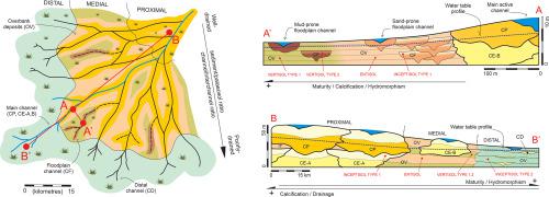
Abstract The stratigraphic record of distributive fluvial systems is commonly characterised by frequent and complex interstratification of palaeosols among channel and overbank deposits. However, current models focus primarily on sedimentation and pay only limited attention to palaeopedogenesis, thereby failing to incorporate important palaeoenvironmental and stratigraphic information. This study proposes a pedosedimentary model for distributive fluvial systems that depicts and accounts for two palaeopedogenetic trends: one downdip, in relation to distality from the fan apex, and one along-strike, in relation to distance from active channel belts. Palaeosols are reported in detail from an Upper Cretaceous succession of the Bauru Basin, southeastern Brazil, through the application of macro-, micromorphological and geochemical studies, combined with facies and architectural-element analyses of sediments. In the downdip palaeopedogenetic trend, the proximal zone of the depositional system is characterised by a dominance of well-drained Inceptisols that develop on amalgamated channel fills; in the medial zone, Inceptisols occur interlayered with overbank deposits containing Entisols and poorly drained Vertisols. The distal zone preserves more mature and poorly drained Inceptisols developed on deposits of overbank and sporadic distal channel fills. These pedotypes show an increase in maturity and hydromorphism, moving away from the apex to the fan toe. This is likely linked to (i) the progressive approach of the topographic surface to the water table, and (ii) the average increase in distance to an active channel belt in distal locations. The along-strike palaeopedogenetic trend culminates in poorly developed palaeosols in floodplain regions that correspond to topographic depressions located between channel belts and which were subject to recurrent floods. Because palaeopedogenesis in the floodplain region is penecontemporaneous to sedimentation, pedotypes show an increase in maturity, bioinduced calcification and hydromorphism with distance from the active channels; they pass laterally from Entisols and Inceptisols near active channels, to Vertisols away from active channels. Conversely, following avulsion, abandoned channel belts remain as topographically elevated alluvial ridges located at some distance from the newly active channels and positioned above the water table and this leads to the development of better drained and better developed Inceptisols relative to pedotypes of the floodplain region. Overall, both palaeopedogenetic trends demonstrate the overriding controls of topography, sedimentation rate and parent material on pedogenesis, with only minor climatic influence. This work offers a novel pedosedimentary model for distributive fluvial systems and highlights the palaeoenvironmental significance of palaeosol trends, providing new constraints for the recognition of distributive fluvial systems in the rock record.
中文翻译:

分布河流系统古土壤的景观和沉积控制(上白垩纪,巴西)
摘要 分布河流系统的地层记录的普遍特征是河道和河岸沉积物中古土壤的频繁和复杂的分层。然而,目前的模型主要关注沉积,而对古土壤发生的关注有限,因此未能纳入重要的古环境和地层信息。本研究提出了一种分布河流系统的土壤沉积模型,该模型描述并解释了两种古土壤发生趋势:一种是向下倾斜,与扇尖的远端有关,另一种是沿走向,与与活动河道带的距离有关。通过宏观、微观形态和地球化学研究,从巴西东南部包鲁盆地的上白垩统层序详细报告了古土壤,结合沉积物的相和建筑元素分析。在下倾的古土壤形成趋势中,沉积系统的近端带的特征是在混合河道填充物上发育的排水良好的 Inceptisol 占主导地位;在中间区域,Inceptisol 与包含 Entisols 和排水不良的 Vertisols 的堤岸沉积物夹在中间。远端区域保留了更成熟且排水不良的 Inceptisol,这些土壤是在堤岸和零星的远端通道填充物的沉积物上形成的。这些基因型表现出成熟度和水态性的增加,从顶端移向扇形脚趾。这可能与 (i) 地形表面逐渐接近地下水位,以及 (ii) 到远端位置活动河道带的距离平均增加有关。沿走向的古土壤形成趋势在洪泛区古土壤发育不良的情况下达到顶峰,这些古土壤对应于位于河道带之间的地形洼地,并受到反复洪水的影响。由于泛滥平原地区的古土壤形成与沉积不同时期,土壤类型显示成熟度增加、生物诱导钙化和水形作用随着距活动河道的距离而增加;它们从活动通道附近的 Entisols 和 Inceptisol 横向传递到远离活动通道的 Vertisols。相反,在撕脱之后,废弃的河道带仍然是地形升高的冲积山脊,位于距新活跃河道一定距离并位于地下水位上方,这导致相对于漫滩地区的土壤类型的更好排水和更发达的 Inceptisol 的发展。总体而言,这两种古土壤发生趋势都表明,地形、沉积速率和母质对成土作用具有压倒性的控制作用,而气候影响很小。这项工作为分布河流系统提供了一种新的沉积模型,并突出了古土壤趋势的古环境意义,为岩石记录中分布河流系统的识别提供了新的约束。沉积速率和母质对成土作用的影响,只有轻微的气候影响。这项工作为分布河流系统提供了一种新的沉积模型,并突出了古土壤趋势的古环境意义,为岩石记录中分布河流系统的识别提供了新的约束。沉积速率和母质对成土作用的影响,只有轻微的气候影响。这项工作为分布河流系统提供了一种新的沉积模型,并突出了古土壤趋势的古环境意义,为岩石记录中分布河流系统的识别提供了新的约束。
更新日期:2020-12-01
中文翻译:
分布河流系统古土壤的景观和沉积控制(上白垩纪,巴西)
摘要 分布河流系统的地层记录的普遍特征是河道和河岸沉积物中古土壤的频繁和复杂的分层。然而,目前的模型主要关注沉积,而对古土壤发生的关注有限,因此未能纳入重要的古环境和地层信息。本研究提出了一种分布河流系统的土壤沉积模型,该模型描述并解释了两种古土壤发生趋势:一种是向下倾斜,与扇尖的远端有关,另一种是沿走向,与与活动河道带的距离有关。通过宏观、微观形态和地球化学研究,从巴西东南部包鲁盆地的上白垩统层序详细报告了古土壤,结合沉积物的相和建筑元素分析。在下倾的古土壤形成趋势中,沉积系统的近端带的特征是在混合河道填充物上发育的排水良好的 Inceptisol 占主导地位;在中间区域,Inceptisol 与包含 Entisols 和排水不良的 Vertisols 的堤岸沉积物夹在中间。远端区域保留了更成熟且排水不良的 Inceptisol,这些土壤是在堤岸和零星的远端通道填充物的沉积物上形成的。这些基因型表现出成熟度和水态性的增加,从顶端移向扇形脚趾。这可能与 (i) 地形表面逐渐接近地下水位,以及 (ii) 到远端位置活动河道带的距离平均增加有关。沿走向的古土壤形成趋势在洪泛区古土壤发育不良的情况下达到顶峰,这些古土壤对应于位于河道带之间的地形洼地,并受到反复洪水的影响。由于泛滥平原地区的古土壤形成与沉积不同时期,土壤类型显示成熟度增加、生物诱导钙化和水形作用随着距活动河道的距离而增加;它们从活动通道附近的 Entisols 和 Inceptisol 横向传递到远离活动通道的 Vertisols。相反,在撕脱之后,废弃的河道带仍然是地形升高的冲积山脊,位于距新活跃河道一定距离并位于地下水位上方,这导致相对于漫滩地区的土壤类型的更好排水和更发达的 Inceptisol 的发展。总体而言,这两种古土壤发生趋势都表明,地形、沉积速率和母质对成土作用具有压倒性的控制作用,而气候影响很小。这项工作为分布河流系统提供了一种新的沉积模型,并突出了古土壤趋势的古环境意义,为岩石记录中分布河流系统的识别提供了新的约束。沉积速率和母质对成土作用的影响,只有轻微的气候影响。这项工作为分布河流系统提供了一种新的沉积模型,并突出了古土壤趋势的古环境意义,为岩石记录中分布河流系统的识别提供了新的约束。沉积速率和母质对成土作用的影响,只有轻微的气候影响。这项工作为分布河流系统提供了一种新的沉积模型,并突出了古土壤趋势的古环境意义,为岩石记录中分布河流系统的识别提供了新的约束。


 京公网安备 11010802027423号