当前位置:
X-MOL 学术
›
Ore Geol. Rev.
›
论文详情
Our official English website, www.x-mol.net, welcomes your
feedback! (Note: you will need to create a separate account there.)
An innovative seismic and statistical approach to understand 3D magmatic structures and ore deposits in the western Bushveld Complex, South Africa
Ore Geology Reviews ( IF 3.2 ) Pub Date : 2020-11-01 , DOI: 10.1016/j.oregeorev.2020.103784 Lebogang Sehoole , Musa S.D. Manzi , Steven E. Zhang , Julie E. Bourdeau
Ore Geology Reviews ( IF 3.2 ) Pub Date : 2020-11-01 , DOI: 10.1016/j.oregeorev.2020.103784 Lebogang Sehoole , Musa S.D. Manzi , Steven E. Zhang , Julie E. Bourdeau
|
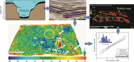
Abstract In this paper, we demonstrate the effectiveness of a novel approach to identify and quantify structural features that disrupt ore-bearing horizons using 3D seismic attributes and a horizon-surface processing technique (difference-of-two-surfaces) on high-resolution 3D reflection seismic data from the Lonmin Platinum Mine in the Bushveld Complex, South Africa. We demonstrate that seismic attribute analysis is an effective tool to enhance the intelligibility of the UG-2, a PGE-enriched chromitite layer, as well as potholes (slump structures), faults, iron-rich ultramafic pegmatite bodies (IRUPs) and other subtle geological features. Furthermore, the horizon-surface processing technique is able to quantify the dimensions and geometry of potholes. In total, we identify 66 potholes and show that they are probably randomly distributed in 2D on the UG-2 horizon with some extent of clustering. Roughly two classes of potholes are identifiable by size. The larger potholes are clustered around a major normal fault (the Marikana Fault) and its branches in the area. Using a first-order pothole structure/geometry statistical analysis, we demonstrate that: (1) the diameters and surface areas of the potholes are strongly related to their depths; and (2) the volume of the potholes is substantially log-normally distributed. We interpret these findings to implicate a coherent and pervasive pothole formation mechanism. Furthermore, we show that statistically-derived pothole structure/geometry knowledge can be used to constrain the validity of several hypotheses. Our findings indicate the most probable pothole formation hypothesis is a widespread extensional regime in the Bushveld Complex magma chamber. Therefore, our study provides important, large-scaled and highly data-driven insights with an approach that can be applied to a wide range of magmatic structures. Furthermore, relationships identified between various pothole characteristics, in addition to their academic value, also allows for predictive modelling that can guide mine planning and resource extraction.
中文翻译:

一种创新的地震和统计方法,用于了解南非布什维尔德综合体西部的 3D 岩浆结构和矿床
摘要 在本文中,我们展示了一种新方法的有效性,该方法使用 3D 地震属性和高分辨率 3D 上的地层表面处理技术(两个表面的差异)来识别和量化破坏含矿层位的结构特征。来自南非 Bushveld Complex 的 Lonmin 铂矿的反射地震数据。我们证明地震属性分析是提高 UG-2、富含 PGE 的铬铁矿层以及坑洞(坍塌结构)、断层、富铁超镁铁质伟晶岩体 (IRUP) 和其他微妙的可理解性的有效工具。地质特征。此外,地平线表面处理技术能够量化坑洼的尺寸和几何形状。总共,我们确定了 66 个坑洼,并表明它们可能随机分布在 UG-2 地平线上的 2D 中,并具有一定程度的聚类。大致可以通过大小识别两类坑洼。较大的坑洼聚集在主要正断层(马里卡纳断层)及其在该地区的分支周围。使用一阶坑洞结构/几何统计分析,我们证明:(1)坑洞的直径和表面积与其深度密切相关;(2)坑洼的体积基本呈对数正态分布。我们将这些发现解释为暗示了一个连贯且普遍的坑洼形成机制。此外,我们表明统计得出的坑洞结构/几何知识可用于限制几种假设的有效性。我们的研究结果表明,最可能的坑洞形成假说是 Bushveld Complex 岩浆房中广泛的伸展机制。因此,我们的研究提供了重要的、大规模的、高度数据驱动的见解,其方法可以应用于广泛的岩浆结构。此外,确定各种坑洼特征之间的关系,除了其学术价值外,还允许进行预测建模,以指导矿山规划和资源开采。
更新日期:2020-11-01
中文翻译:
一种创新的地震和统计方法,用于了解南非布什维尔德综合体西部的 3D 岩浆结构和矿床
摘要 在本文中,我们展示了一种新方法的有效性,该方法使用 3D 地震属性和高分辨率 3D 上的地层表面处理技术(两个表面的差异)来识别和量化破坏含矿层位的结构特征。来自南非 Bushveld Complex 的 Lonmin 铂矿的反射地震数据。我们证明地震属性分析是提高 UG-2、富含 PGE 的铬铁矿层以及坑洞(坍塌结构)、断层、富铁超镁铁质伟晶岩体 (IRUP) 和其他微妙的可理解性的有效工具。地质特征。此外,地平线表面处理技术能够量化坑洼的尺寸和几何形状。总共,我们确定了 66 个坑洼,并表明它们可能随机分布在 UG-2 地平线上的 2D 中,并具有一定程度的聚类。大致可以通过大小识别两类坑洼。较大的坑洼聚集在主要正断层(马里卡纳断层)及其在该地区的分支周围。使用一阶坑洞结构/几何统计分析,我们证明:(1)坑洞的直径和表面积与其深度密切相关;(2)坑洼的体积基本呈对数正态分布。我们将这些发现解释为暗示了一个连贯且普遍的坑洼形成机制。此外,我们表明统计得出的坑洞结构/几何知识可用于限制几种假设的有效性。我们的研究结果表明,最可能的坑洞形成假说是 Bushveld Complex 岩浆房中广泛的伸展机制。因此,我们的研究提供了重要的、大规模的、高度数据驱动的见解,其方法可以应用于广泛的岩浆结构。此外,确定各种坑洼特征之间的关系,除了其学术价值外,还允许进行预测建模,以指导矿山规划和资源开采。


 京公网安备 11010802027423号