当前位置:
X-MOL 学术
›
J. Hydrol.
›
论文详情
Our official English website, www.x-mol.net, welcomes your
feedback! (Note: you will need to create a separate account there.)
Sensitivity of various topographic data in flood management: Implications on inundation mapping over large data-scarce regions
Journal of Hydrology ( IF 5.9 ) Pub Date : 2020-11-01 , DOI: 10.1016/j.jhydrol.2020.125523 Mohit Prakash Mohanty , S. Nithya , Akhilesh S. Nair , J. Indu , Subimal Ghosh , Chandra Mohan Bhatt , Goru Srinivasa Rao , Subhankar Karmakar
Journal of Hydrology ( IF 5.9 ) Pub Date : 2020-11-01 , DOI: 10.1016/j.jhydrol.2020.125523 Mohit Prakash Mohanty , S. Nithya , Akhilesh S. Nair , J. Indu , Subimal Ghosh , Chandra Mohan Bhatt , Goru Srinivasa Rao , Subhankar Karmakar
|
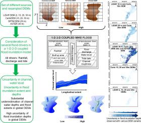
Abstract Topographic data in the form of digital elevation models (DEMs) play a significant role in flood management. Despite the increasing availability of DEMs for large regions, there is a need to evaluate their performance at the inundation/flood level, while considering the overall complexity of flood models. The present study identifies, for the first time, the uncertainties generated in both river channel and overland flooding while considering a set of nine variants from various sources (LiDAR, Cartosat, SRTM, and ASTER) and grid resolutions (resampled versions) in the presence of discharge, rainfall, and tide boundary conditions for a severely flood-prone catchment in the Mahanadi River Basin, India. Extensive geostatistical analyses reveal the existence of significant biases with global DEMs i.e., SRTM and ASTER, whereas interestingly the LiDAR and Carto DEMs exhibit a high degree of isotropy. The global DEMs fail to capture several inundated spots; thus plummeting the flood inundation extents to a sufficient degree of unacceptability. Prominently, the inability in identifying high and very high flood depths (>1.5 m) over the coastal stretches results in large uncertainties in the majority of the grids. Our analysis reveals the existence of significant noise in global DEMs, which nullifies the hydrodynamic interaction during the coupling of 1-D and 2-D flood models in presence of tidal influence. We recommend that under unavailability of precise LiDAR DEMs, resampled and freely available Carto DEMs, that are as efficient as LiDAR if not more, be given higher preference. We caution against the copious usage of global DEMs for large data-scarce and flood-prone regions, as the DEM uncertainty may be substantially amplified at the inundation level during combined channel and overland flood simulations. Through this study, we would like to recommend the proposed framework as a guided step while selecting appropriate DEM for flood inundation mapping over large data scarce regions.
中文翻译:

洪水管理中各种地形数据的敏感性:对大数据稀缺地区洪水测绘的影响
摘要 数字高程模型 (DEM) 形式的地形数据在洪水管理中发挥着重要作用。尽管大区域 DEM 的可用性越来越高,但仍需要在考虑洪水模型的整体复杂性的同时,评估它们在洪水/洪水水平上的性能。本研究首次确定了河道和陆上洪水中产生的不确定性,同时考虑了来自不同来源(LiDAR、Cartosat、SRTM 和 ASTER)和网格分辨率(重新采样版本)的一组九个变体。印度马哈纳迪河流域一个严重易发洪水的集水区的流量、降雨和潮汐边界条件。广泛的地质统计分析揭示了全球 DEM 存在显着偏差,即 SRTM 和 ASTER,而有趣的是,LiDAR 和 Carto DEM 表现出高度的各向同性。全球 DEM 未能捕捉到几个淹没点;从而使洪水淹没程度急剧下降到足以令人无法接受的程度。突出的是,无法识别沿海延伸的高和非常高的洪水深度(> 1.5 m)导致大多数网格中存在很大的不确定性。我们的分析揭示了全球 DEM 中存在显着噪声,这在存在潮汐影响的情况下使一维和二维洪水模型耦合期间的水动力相互作用无效。我们建议,在精确 LiDAR DEM 不可用的情况下,重新采样和免费提供的 Carto DEM,与 LiDAR 一样有效,如果不是更多,则给予更高的优先权。我们警告不要在大数据稀缺和洪水易发地区大量使用全球 DEM,因为在联合渠道和陆上洪水模拟期间,DEM 的不确定性可能会在淹没水平上被大大放大。通过这项研究,我们想推荐建议的框架作为指导步骤,同时为大数据稀缺区域的洪水淹没绘图选择合适的 DEM。
更新日期:2020-11-01
中文翻译:
洪水管理中各种地形数据的敏感性:对大数据稀缺地区洪水测绘的影响
摘要 数字高程模型 (DEM) 形式的地形数据在洪水管理中发挥着重要作用。尽管大区域 DEM 的可用性越来越高,但仍需要在考虑洪水模型的整体复杂性的同时,评估它们在洪水/洪水水平上的性能。本研究首次确定了河道和陆上洪水中产生的不确定性,同时考虑了来自不同来源(LiDAR、Cartosat、SRTM 和 ASTER)和网格分辨率(重新采样版本)的一组九个变体。印度马哈纳迪河流域一个严重易发洪水的集水区的流量、降雨和潮汐边界条件。广泛的地质统计分析揭示了全球 DEM 存在显着偏差,即 SRTM 和 ASTER,而有趣的是,LiDAR 和 Carto DEM 表现出高度的各向同性。全球 DEM 未能捕捉到几个淹没点;从而使洪水淹没程度急剧下降到足以令人无法接受的程度。突出的是,无法识别沿海延伸的高和非常高的洪水深度(> 1.5 m)导致大多数网格中存在很大的不确定性。我们的分析揭示了全球 DEM 中存在显着噪声,这在存在潮汐影响的情况下使一维和二维洪水模型耦合期间的水动力相互作用无效。我们建议,在精确 LiDAR DEM 不可用的情况下,重新采样和免费提供的 Carto DEM,与 LiDAR 一样有效,如果不是更多,则给予更高的优先权。我们警告不要在大数据稀缺和洪水易发地区大量使用全球 DEM,因为在联合渠道和陆上洪水模拟期间,DEM 的不确定性可能会在淹没水平上被大大放大。通过这项研究,我们想推荐建议的框架作为指导步骤,同时为大数据稀缺区域的洪水淹没绘图选择合适的 DEM。


 京公网安备 11010802027423号