Ecological Indicators ( IF 7.0 ) Pub Date : 2020-09-15 , DOI: 10.1016/j.ecolind.2020.106883 Xin Lyu , Xiaobing Li , Jirui Gong , Shengkun Li , Huashun Dou , Dongliang Dang , Xiaojing Xuan , Hong Wang
|
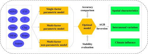
Aboveground biomass (AGB) is a fundamental parameter used in grassland-related research, for which remote sensing has become an effective inversion technology on a regional level. Using a typical steppe in Inner Mongolia, China as an example, this study constructed a single-factor parametric model, a multifactor parametric model, and a multifactor nonparametric model to estimate the grassland AGB from actual field measurement data. We compared the accuracy and stability of the various models using a ten-fold cross-validation method and established a remote-sensing inversion model for grassland AGB. On this basis, we simulated the grassland AGB from 2015 to 2019 in the study area, analyzed its spatial–temporal distribution characteristics, and discussed the effects of these climatic factors. The research results showed that the accuracy and stability of the various models ranked as follows: back-propagation artificial neural network (BP-ANN) inversion model > multifactor parametric model > single-factor parametric model. The simulation capability of the BP-ANN inversion model for grassland AGB was effectively improved by averaging the repeated modeling results. The grassland AGB of the study area from 2015 through 2019 showed a spatial distribution of gradual increase from the northwest to the southeast and an inter-annual trend of increasing over time. The spatial and temporal distribution characteristics were closely related to the amount of precipitation. The research results can provide a direct reference for remote-sensing monitoring of grassland AGB and provide accurate spatial data as well as a scientific basis for sustained development of regional grassland.


 京公网安备 11010802027423号