当前位置:
X-MOL 学术
›
Q. J. R. Meteorol. Soc.
›
论文详情
Our official English website, www.x-mol.net, welcomes your
feedback! (Note: you will need to create a separate account there.)
Effects of terrain‐following vertical coordinates on simulation of stratus clouds in numerical weather prediction models
Quarterly Journal of the Royal Meteorological Society ( IF 3.0 ) Pub Date : 2020-09-13 , DOI: 10.1002/qj.3907 Stephanie Westerhuis 1, 2 , Oliver Fuhrer 2, 3 , Ritthik Bhattacharya 4 , Jürg Schmidli 4 , Christopher Bretherton 3, 5
Quarterly Journal of the Royal Meteorological Society ( IF 3.0 ) Pub Date : 2020-09-13 , DOI: 10.1002/qj.3907 Stephanie Westerhuis 1, 2 , Oliver Fuhrer 2, 3 , Ritthik Bhattacharya 4 , Jürg Schmidli 4 , Christopher Bretherton 3, 5
Affiliation
|
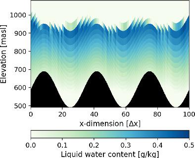
Many numerical weather prediction models employ terrain‐following vertical coordinates. As a consequence, over orography, flat tops of stratus clouds are intersected by the vertical coordinate surfaces. We conduct idealised two‐dimensional simulations of a stratus cloud with the COSMO model to study the effect of such sloping vertical coordinate surfaces. The evolution of the stratus cloud above a flat surface within a horizontally homogeneous atmosphere serves as a reference. During night‐time, the cloud thickens, driven by radiative cooling at the cloud top. Adding a sinusoidal perturbation to the vertical coordinate surfaces reduces the growth of the stratus cloud. With strong perturbations, the cloud starts to dissipate. The physical processes in the two simulations are identical, hence this behaviour is purely driven by numerical diffusion. The cloud is similarly thinned when sinusoidal orographic features are introduced. The reduction depends on the amplitude and wavelength of the perturbations and hills. Increasing the horizontal resolution partly mitigates the numerical diffusion. However, this is a very costly measure for an operational weather model. We suggest conducting further research on a new vertical coordinate with additional local smoothing of the orographic signal.
中文翻译:

地形跟随垂直坐标对数值天气预报模型中层云模拟的影响
许多数值天气预报模型都采用了跟随地形的垂直坐标。结果,在地形上,地层云的平顶被垂直坐标表面相交。我们使用COSMO模型对层云进行了理想的二维模拟,以研究这种倾斜的垂直坐标曲面的影响。在水平均匀的大气层中,平坦表面上方的地层云的演化可作为参考。在夜间,由于云顶辐射冷却的作用,云层变厚。向垂直坐标表面添加正弦扰动会减少层云的增长。随着强烈的干扰,云开始消散。两次模拟中的物理过程是相同的,因此,这种行为纯粹是由数值扩散驱动的。当引入正弦形地形特征时,云同样变薄。减少取决于扰动和波谷的振幅和波长。增加水平分辨率可部分缓解数值扩散。但是,对于运行天气模型,这是非常昂贵的措施。我们建议对新的垂直坐标进行进一步的研究,同时对地形信号进行额外的局部平滑处理。
更新日期:2020-09-13
中文翻译:
地形跟随垂直坐标对数值天气预报模型中层云模拟的影响
许多数值天气预报模型都采用了跟随地形的垂直坐标。结果,在地形上,地层云的平顶被垂直坐标表面相交。我们使用COSMO模型对层云进行了理想的二维模拟,以研究这种倾斜的垂直坐标曲面的影响。在水平均匀的大气层中,平坦表面上方的地层云的演化可作为参考。在夜间,由于云顶辐射冷却的作用,云层变厚。向垂直坐标表面添加正弦扰动会减少层云的增长。随着强烈的干扰,云开始消散。两次模拟中的物理过程是相同的,因此,这种行为纯粹是由数值扩散驱动的。当引入正弦形地形特征时,云同样变薄。减少取决于扰动和波谷的振幅和波长。增加水平分辨率可部分缓解数值扩散。但是,对于运行天气模型,这是非常昂贵的措施。我们建议对新的垂直坐标进行进一步的研究,同时对地形信号进行额外的局部平滑处理。


 京公网安备 11010802027423号