当前位置:
X-MOL 学术
›
Atmos. Environ.
›
论文详情
Our official English website, www.x-mol.net, welcomes your
feedback! (Note: you will need to create a separate account there.)
Estimation of the NO2 population exposure in the Northern Harbour district of Malta
Atmospheric Environment ( IF 4.2 ) Pub Date : 2021-01-01 , DOI: 10.1016/j.atmosenv.2020.117918 Sara Fenech , Noel J. Aquilina
Atmospheric Environment ( IF 4.2 ) Pub Date : 2021-01-01 , DOI: 10.1016/j.atmosenv.2020.117918 Sara Fenech , Noel J. Aquilina
|
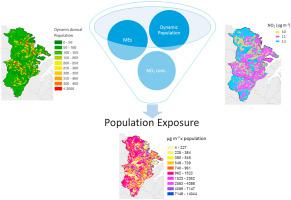
Abstract This study presents an estimate of the total NO2 exposure in a polluted and densely populated region in Malta, the Northern Harbour district. To estimate the population mobility, we follow a dynamic approach whereby four microenvironments are mapped onto defined Copernicus Urban Atlas 2012 land use classifications. These include the home (ME_home), work (ME_work), traffic (ME_traffic), and other outdoor activities (ME_other) microenvironments. In addition, generic time-activity profiles are used to estimate the hourly mobility in the different microenvironments depending on weekday or weekend profiles. Measured hourly NO2 ambient concentrations from the air quality network run by the Environment and Resources Authority (ERA) are used in conjunction with the estimated time-activity profiles to calculate the total exposure. The highest NO2 population exposure is estimated for ME_home (71%) as people spend the majority of the time in this microenvironment followed by ME_other (15%), ME_work (10%) and ME_traffic (4%), respectively. In addition, we test the sensitivity of the total NO2 exposure to changes in NO2 concentrations for different microenvironments. The total NO2 exposure using infiltration rates to estimate infiltrated outdoor NO2 concentrations in indoor microenvironments, is up to 25% lower compared to the NO2 exposure estimated using outdoor NO2 concentrations for all microenvironments. Results also suggest a decrease of 3% in the estimated NO2 exposure if a static population is assumed for each microenvironment as opposed to a dynamic one. Exposure assessments such as that presented in this study are essential to aid the development of targeted policies to limit such exposures.
中文翻译:

马耳他北部海港区二氧化氮人群暴露估算
摘要 本研究估计了马耳他北部海港区污染和人口稠密地区的 NO2 暴露总量。为了估计人口流动,我们采用动态方法,将四个微环境映射到定义的哥白尼城市地图集 2012 土地利用分类上。这些包括家庭 (ME_home)、工作 (ME_work)、交通 (ME_traffic) 和其他户外活动 (ME_other) 微环境。此外,通用时间-活动曲线用于根据工作日或周末曲线估计不同微环境中的每小时流动性。环境和资源管理局 (ERA) 运行的空气质量网络中测量的每小时 NO2 环境浓度与估计的时间-活动曲线结合使用,以计算总暴露量。ME_home (71%) 的 NO2 人群暴露量最高,因为人们大部分时间都在这种微环境中度过,其次是 ME_other (15%)、ME_work (10%) 和 ME_traffic (4%)。此外,我们测试了总 NO2 暴露对不同微环境中 NO2 浓度变化的敏感性。与使用室外 NO2 浓度估计的所有微环境中的 NO2 暴露相比,使用渗透率估计室内微环境中渗透的室外 NO2 浓度的总 NO2 暴露量最多降低 25%。结果还表明,如果假设每个微环境为静态种群而不是动态种群,则估计的 NO2 暴露量会减少 3%。
更新日期:2021-01-01
中文翻译:
马耳他北部海港区二氧化氮人群暴露估算
摘要 本研究估计了马耳他北部海港区污染和人口稠密地区的 NO2 暴露总量。为了估计人口流动,我们采用动态方法,将四个微环境映射到定义的哥白尼城市地图集 2012 土地利用分类上。这些包括家庭 (ME_home)、工作 (ME_work)、交通 (ME_traffic) 和其他户外活动 (ME_other) 微环境。此外,通用时间-活动曲线用于根据工作日或周末曲线估计不同微环境中的每小时流动性。环境和资源管理局 (ERA) 运行的空气质量网络中测量的每小时 NO2 环境浓度与估计的时间-活动曲线结合使用,以计算总暴露量。ME_home (71%) 的 NO2 人群暴露量最高,因为人们大部分时间都在这种微环境中度过,其次是 ME_other (15%)、ME_work (10%) 和 ME_traffic (4%)。此外,我们测试了总 NO2 暴露对不同微环境中 NO2 浓度变化的敏感性。与使用室外 NO2 浓度估计的所有微环境中的 NO2 暴露相比,使用渗透率估计室内微环境中渗透的室外 NO2 浓度的总 NO2 暴露量最多降低 25%。结果还表明,如果假设每个微环境为静态种群而不是动态种群,则估计的 NO2 暴露量会减少 3%。


 京公网安备 11010802027423号