当前位置:
X-MOL 学术
›
Basin Res.
›
论文详情
Our official English website, www.x-mol.net, welcomes your
feedback! (Note: you will need to create a separate account there.)
Development of an incipient Paleogene topography between the present‐day Eastern Andean Plateau (Puna) and the Eastern Cordillera, southern Central Andes, NW Argentina
Basin Research ( IF 2.8 ) Pub Date : 2020-09-08 , DOI: 10.1111/bre.12510 Carolina Montero‐López 1 , Fernando Hongn 1 , Romina L. López Steinmetz 2 , Alejandro Aramayo 1 , Heiko Pingel 3 , Manfred R. Strecker 3 , John M. Cottle 4 , Carlos Bianchi 1
Basin Research ( IF 2.8 ) Pub Date : 2020-09-08 , DOI: 10.1111/bre.12510 Carolina Montero‐López 1 , Fernando Hongn 1 , Romina L. López Steinmetz 2 , Alejandro Aramayo 1 , Heiko Pingel 3 , Manfred R. Strecker 3 , John M. Cottle 4 , Carlos Bianchi 1
Affiliation
|
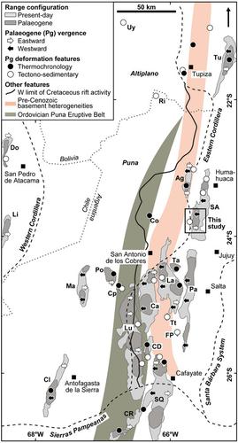
The structural and topographic evolution of orogenic plateaus is an important research topic because of its impact on atmospheric circulation patterns, the amount and distribution of rainfall, and resulting changes in surface processes. The Puna region in the north‐western Argentina (between 13°S and 27°S) is part of the Andean Plateau, which is the world's second largest orogenic plateau. In order to investigate the deformational events responsible for the initial growth of this part of the Andean plateau, we carried out structural and stratigraphic investigations within the present‐day transition zone between the northern Puna and the adjacent Eastern Cordillera to the east. This transition zone is characterized by ubiquitous exposures of continental middle Eocene redbeds of the Casa Grande Formation. Our structural mapping, together with a sedimentological analysis of these units and their relationships with the adjacent mountain ranges, has revealed growth structures and unconformities that are indicative of syntectonic deposition. These findings support the notion that tectonic shortening in this part of the Central Andes was already active during the middle Paleogene, and that early Cenozoic deformation in the region that now constitutes the Puna occurred in a spatially irregular manner. The patterns of Paleogene deformation and uplift along the eastern margin of the present‐day plateau correspond to an approximately north‐south oriented swath of reactivated basement heterogeneities (i.e. zones of mechanical weakness) stemming from regional Paleozoic mountain building that may have led to local concentration of deformation belts.
中文翻译:

在现今的东部安第斯高原(Puna)和阿根廷西北部安第斯山脉中部南部的东部山脉之间建立起古古近纪地形
造山带的结构和地形演变是一个重要的研究课题,因为它对大气环流模式,降雨的数量和分布以及地表过程的变化有影响。阿根廷西北部的普纳地区(介于13°S和27°S之间)是安第斯高原的一部分,安第斯高原是世界第二大造山带高原。为了调查负责安第斯高原这一部分初始生长的形变事件,我们在北普纳和东部相邻的东部山脉之间的当今过渡带内进行了结构和地层研究。该过渡带的特征是卡萨格兰德组的中新世大陆中部普遍存在裸露。我们的结构图 结合对这些单元的沉积学分析以及它们与邻近山脉的关系,揭示了表明构造沉积的生长结构和不整合面。这些发现支持了这样的观点,即中安第斯山脉中部的这一区域的构造缩短已经在古近纪中期活跃,而现在构成普纳地区的早新生代变形以空间上不规则的方式发生。沿今天高原东缘的古近纪变形和隆升的模式对应于重新活化的基底异质性(即机械弱化区)的大约南北走向的条带,其源于区域性的古生代山地建筑,可能导致局部集中变形带。
更新日期:2020-09-08
中文翻译:
在现今的东部安第斯高原(Puna)和阿根廷西北部安第斯山脉中部南部的东部山脉之间建立起古古近纪地形
造山带的结构和地形演变是一个重要的研究课题,因为它对大气环流模式,降雨的数量和分布以及地表过程的变化有影响。阿根廷西北部的普纳地区(介于13°S和27°S之间)是安第斯高原的一部分,安第斯高原是世界第二大造山带高原。为了调查负责安第斯高原这一部分初始生长的形变事件,我们在北普纳和东部相邻的东部山脉之间的当今过渡带内进行了结构和地层研究。该过渡带的特征是卡萨格兰德组的中新世大陆中部普遍存在裸露。我们的结构图 结合对这些单元的沉积学分析以及它们与邻近山脉的关系,揭示了表明构造沉积的生长结构和不整合面。这些发现支持了这样的观点,即中安第斯山脉中部的这一区域的构造缩短已经在古近纪中期活跃,而现在构成普纳地区的早新生代变形以空间上不规则的方式发生。沿今天高原东缘的古近纪变形和隆升的模式对应于重新活化的基底异质性(即机械弱化区)的大约南北走向的条带,其源于区域性的古生代山地建筑,可能导致局部集中变形带。


 京公网安备 11010802027423号