当前位置:
X-MOL 学术
›
Geomorphology
›
论文详情
Our official English website, www.x-mol.net, welcomes your
feedback! (Note: you will need to create a separate account there.)
A new digital bathymetric model of the South China Sea based on the subregional fusion of seven global seafloor topography products
Geomorphology ( IF 3.1 ) Pub Date : 2020-12-01 , DOI: 10.1016/j.geomorph.2020.107403 Xiaoguang Ruan , Liang Cheng , Sensen Chu , Zhaojin Yan , Xiao Zhou , Zhixin Duan , Manchun Li
Geomorphology ( IF 3.1 ) Pub Date : 2020-12-01 , DOI: 10.1016/j.geomorph.2020.107403 Xiaoguang Ruan , Liang Cheng , Sensen Chu , Zhaojin Yan , Xiao Zhou , Zhixin Duan , Manchun Li
|
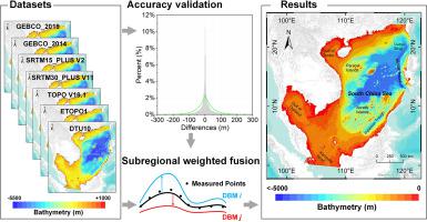
Abstract An understanding of ocean bathymetry is important in marine planning, navigation, military activities, and environmental monitoring. The fusion of spatial data, such as those from multi-source digital bathymetric models (DBMs), can effectively improve the efficiency of large-scale seafloor topographical research and the accuracy of the results obtained therein. On the one hand, with the release of 15arc-seconds resolution DBMs, it is now necessary to verify the quality of these new products. On the other hand, in order to generate a new, high-quality, seamless DBM in the South China Sea (SCS) and adjacent areas, an adaptive subregional spatial-domain-weighted fusion framework is proposed. First, seven of the most widely used global DBMs are selected, and multi-source subregional measured depth-sounding data undergo data cleaning and other preprocessing. Next, based on the homogeneity of the terrain features, an adaptive subregional topographical analysis is performed, and the subregional data are weight-fused. Finally, the fusion dataset is post-processed via model smoothing and other procedures. In addition, the advantages and limitations of the DBMs of the SCS are compared. The results show that SRTM15_PLUS V2 is the most reliable of the original DBMs. The updated seamless SCS DBM is void-free and more similar to SRTM15_PLUS V2 with a resolution of 15arc-seconds. The root mean square error (RMSE) of the new model is 99.60 m. Its accuracy is 13%, 40%, 15%, and 1% higher than those achieved by the GEBCO_2019, GEBCO_2014, SRTM30_PLUS, and SRTM15_PLUS models, respectively, and its expression of the topography is more detailed and realistic. The feasibility and limitations of the proposed fusion framework are demonstrated. The present findings provide a useful reference for the timely reconstruction and updating of large-scale seafloor topography from multiple datasets.
中文翻译:

基于全球七大海底地形产品次区域融合的南海数字测深新模型
摘要 对海洋测深的理解在海洋规划、导航、军事活动和环境监测中具有重要意义。空间数据的融合,例如来自多源数字测深模型(DBMs)的空间数据,可以有效提高大规模海底地形研究的效率和所得结果的准确性。一方面,随着15弧秒分辨率DBM的发布,现在有必要验证这些新产品的质量。另一方面,为了在南海(SCS)及邻近地区生成新的、高质量、无缝的DBM,提出了一种自适应的次区域空间域加权融合框架。首先,选择了七个最广泛使用的全球 DBM,多源次区域实测测深数据经过数据清洗等预处理。接下来,基于地形特征的同质性,进行自适应分区域地形分析,并对分区域数据进行权重融合。最后,融合数据集通过模型平滑和其他程序进行后处理。此外,还比较了 SCS 的 DBM 的优点和局限性。结果表明,SRTM15_PLUS V2 是最可靠的原始 DBM。更新后的无缝 SCS DBM 无空隙,更类似于分辨率为 15 弧秒的 SRTM15_PLUS V2。新模型的均方根误差 (RMSE) 为 99.60 m。其精度比GEBCO_2019、GEBCO_2014、SRTM30_PLUS和SRTM15_PLUS模型分别提高了13%、40%、15%和1%,并且它对地形的表达更加细致逼真。证明了所提出的融合框架的可行性和局限性。目前的研究结果为从多个数据集及时重建和更新大规模海底地形提供了有用的参考。
更新日期:2020-12-01
中文翻译:
基于全球七大海底地形产品次区域融合的南海数字测深新模型
摘要 对海洋测深的理解在海洋规划、导航、军事活动和环境监测中具有重要意义。空间数据的融合,例如来自多源数字测深模型(DBMs)的空间数据,可以有效提高大规模海底地形研究的效率和所得结果的准确性。一方面,随着15弧秒分辨率DBM的发布,现在有必要验证这些新产品的质量。另一方面,为了在南海(SCS)及邻近地区生成新的、高质量、无缝的DBM,提出了一种自适应的次区域空间域加权融合框架。首先,选择了七个最广泛使用的全球 DBM,多源次区域实测测深数据经过数据清洗等预处理。接下来,基于地形特征的同质性,进行自适应分区域地形分析,并对分区域数据进行权重融合。最后,融合数据集通过模型平滑和其他程序进行后处理。此外,还比较了 SCS 的 DBM 的优点和局限性。结果表明,SRTM15_PLUS V2 是最可靠的原始 DBM。更新后的无缝 SCS DBM 无空隙,更类似于分辨率为 15 弧秒的 SRTM15_PLUS V2。新模型的均方根误差 (RMSE) 为 99.60 m。其精度比GEBCO_2019、GEBCO_2014、SRTM30_PLUS和SRTM15_PLUS模型分别提高了13%、40%、15%和1%,并且它对地形的表达更加细致逼真。证明了所提出的融合框架的可行性和局限性。目前的研究结果为从多个数据集及时重建和更新大规模海底地形提供了有用的参考。


 京公网安备 11010802027423号