Water Research ( IF 11.4 ) Pub Date : 2020-09-02 , DOI: 10.1016/j.watres.2020.116353 Diane Espel 1 , Stephanie Courty 2 , Yves Auda 3 , David Sheeren 4 , Arnaud Elger 5
|
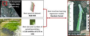
Submerged macrophyte monitoring is a major concern for hydrosystem management, particularly for understanding and preventing the potential impacts of global change on ecological functions and services. Macrophyte distribution assessments in rivers are still primarily realized using field monitoring or manual photo-interpretation of aerial images. Considering the lack of applications in fluvial environments, developing operational, low-cost and less time-consuming tools able to automatically map and monitor submerged macrophyte distribution is therefore crucial to support effective management programs. In this study, the suitability of very fine-scale resolution (50 cm) multispectral Pléiades satellite imagery to estimate submerged macrophyte cover, at the scale of a 1 km river section, was investigated. The performance of nonparametric regression methods (based on two reliable and well-known machine learning algorithms for remote sensing applications, Random Forest and Support Vector Regression) were compared for several spectral datasets, testing the relevance of 4 spectral bands (red, green, blue and near-infrared) and two vegetation indices (the Normalized Difference Vegetation Index, NDVI, and the Green-Red Vegetation Index, GRVI), and for several field sampling configurations. Both machine learning algorithms applied to a Pléiades image were able to reasonably well predict macrophyte cover in river ecosystems with promising performance metrics (R² above 0.7 and RMSE around 20%). The Random Forest algorithm combined to the 4 spectral bands from Pléiades image was the most efficient, particularly for extreme cover values (0% and 100%). Our study also demonstrated that a larger number of fine-scale field sampling entities clearly involved better cover predictions than a smaller number of larger sampling entities.
中文翻译:
河流中大型植物的淹没评估:使用P病影像的自动制图方法。
淹没植物的监测是水文系统管理的主要关注点,特别是对于了解和预防全球变化对生态功能和服务的潜在影响而言。河流中大型植物分布评估仍主要通过野外监测或航空影像的手动照片解释来实现。考虑到在河流环境中缺乏应用程序,因此开发能够自动映射和监视水下大型植物分布的可操作,低成本且耗时较少的工具对于支持有效的管理计划至关重要。在这项研究中,研究了非常精细的分辨率(50厘米)的多光谱P宿星卫星图像在1公里河段规模上估计淹没植物的覆盖率的适用性。比较了几种光谱数据集的非参数回归方法(基于两种可靠且著名的遥感应用机器学习算法,随机森林和支持向量回归)的性能,测试了四个光谱带(红色,绿色,蓝色)的相关性和近红外)和两个植被指数(归一化差异植被指数NDVI和绿红植被指数GRVI),并且适用于几种野外采样配置。两种应用于Pléiades图像的机器学习算法均能够以良好的性能指标合理地很好地预测河流生态系统中的大型植物覆盖率(测试4个光谱带(红色,绿色,蓝色和近红外)和两个植被指数(归一化差异植被指数NDVI和绿红植被指数GRVI)的相关性,并测试几种野外采样配置。两种应用于Pléiades图像的机器学习算法均能够以良好的性能指标合理地很好地预测河流生态系统中的大型植物覆盖率(测试4个光谱带(红色,绿色,蓝色和近红外)和两个植被指数(归一化差异植被指数NDVI和绿红植被指数GRVI)的相关性,并测试几种野外采样配置。两种应用于Pléiades图像的机器学习算法均能够以良好的性能指标合理地很好地预测河流生态系统中的大型植物覆盖率(ř ²高于0.7和RMSE约20%)。结合到algorithm宿星图像的4个光谱带的随机森林算法是最有效的,特别是对于极端覆盖值(0%和100%)。我们的研究还表明,与少量较大的采样实体相比,大量的精细现场采样实体显然具有更好的覆盖率预测。


 京公网安备 11010802027423号