当前位置:
X-MOL 学术
›
Appl. Geogr.
›
论文详情
Our official English website, www.x-mol.net, welcomes your
feedback! (Note: you will need to create a separate account there.)
Integration of social, economic and environmental factors in GIS for land degradation vulnerability assessment in the Pir Panjal Himalaya, Kashmir, India
Applied Geography ( IF 4.0 ) Pub Date : 2020-12-01 , DOI: 10.1016/j.apgeog.2020.102307 Shakil Ahmad Romshoo , Muzamil Amin , K.L.N. Sastry , Manish Parmar
Applied Geography ( IF 4.0 ) Pub Date : 2020-12-01 , DOI: 10.1016/j.apgeog.2020.102307 Shakil Ahmad Romshoo , Muzamil Amin , K.L.N. Sastry , Manish Parmar
|
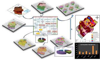
Abstract Land degradation assessment is imperative for developing a mitigation plan to minimize the adverse impacts associated with land degradation. The study involves the integration of various social, economic and environmental indices for identifying the land degradation vulnerable areas in the Pir Panjal Himalaya, Kashmir, India. Analysis of the land use and land cover from the satellite data revealed that ~47% of the area is devoid of any vegetal cover. Slope index revealed that ~40% of the study area is precipitous with slope >30%. The land utilization index indicated that ~51% of the area is over-utilized. Integration of all the environmental indices in GIS environment yielded the Natural Resource Prioritization Index which revealed that ~41% of the area needs attention for land degradation mitigation on top priority. Integration of all the socioeconomic indices yielded the Socio-Economic Priority Zones which revealed that ~35% of the area needs attention for the socio-economic upliftment on priority for combating the land degradation in the study area. Land Degradation Vulnerability Index (LDVI) model was developed in GIS environment based on the unique combination of various natural resource and socioeconomic priority zones using the weighted index approach to assess the cumulative impact of social, economic and environmental factors on land degradation. The model analyses revealed that ~48% of the study area (~603 Km2) shows high to very high LDVI values alluding to its high vulnerability to different forms of land degradation. The approach developed in this research for the integration of various causal factors to identify the lands vulnerable to varying degree and intensity of degradation will go a long way in developing appropriate mitigation strategies for combating land degradation at village level in the Himalaya.
中文翻译:

将社会、经济和环境因素整合到 GIS 中,用于印度克什米尔 Pir Panjal Himalaya 土地退化脆弱性评估
摘要 土地退化评估对于制定减缓计划以尽量减少与土地退化相关的不利影响至关重要。该研究涉及整合各种社会、经济和环境指标,以确定印度克什米尔 Pir Panjal 喜马拉雅地区的土地退化脆弱地区。对卫星数据中土地利用和土地覆盖的分析显示,约 47% 的区域没有任何植被覆盖。坡度指数显示,约 40% 的研究区域是陡峭的,坡度 >30%。土地利用指数表明,约 51% 的区域被过度利用。GIS 环境中所有环境指标的整合产生了自然资源优先排序指数,该指数显示约 41% 的区域需要关注以缓解土地退化作为重中之重。所有社会经济指标的整合产生了社会经济优先区,这表明约 35% 的地区需要关注社会经济提升,以优先解决研究区的土地退化问题。土地退化脆弱性指数(LDVI)模型是在地理信息系统环境下,基于各种自然资源和社会经济优先区的独特组合,采用加权指数方法来评估社会、经济和环境因素对土地退化的累积影响。模型分析显示,约 48% 的研究区域(约 603 平方公里)显示出从高到非常高的 LDVI 值,暗指其对不同形式土地退化的高度脆弱性。
更新日期:2020-12-01
中文翻译:
将社会、经济和环境因素整合到 GIS 中,用于印度克什米尔 Pir Panjal Himalaya 土地退化脆弱性评估
摘要 土地退化评估对于制定减缓计划以尽量减少与土地退化相关的不利影响至关重要。该研究涉及整合各种社会、经济和环境指标,以确定印度克什米尔 Pir Panjal 喜马拉雅地区的土地退化脆弱地区。对卫星数据中土地利用和土地覆盖的分析显示,约 47% 的区域没有任何植被覆盖。坡度指数显示,约 40% 的研究区域是陡峭的,坡度 >30%。土地利用指数表明,约 51% 的区域被过度利用。GIS 环境中所有环境指标的整合产生了自然资源优先排序指数,该指数显示约 41% 的区域需要关注以缓解土地退化作为重中之重。所有社会经济指标的整合产生了社会经济优先区,这表明约 35% 的地区需要关注社会经济提升,以优先解决研究区的土地退化问题。土地退化脆弱性指数(LDVI)模型是在地理信息系统环境下,基于各种自然资源和社会经济优先区的独特组合,采用加权指数方法来评估社会、经济和环境因素对土地退化的累积影响。模型分析显示,约 48% 的研究区域(约 603 平方公里)显示出从高到非常高的 LDVI 值,暗指其对不同形式土地退化的高度脆弱性。


 京公网安备 11010802027423号