Environmental Modelling & Software ( IF 4.8 ) Pub Date : 2020-09-01 , DOI: 10.1016/j.envsoft.2020.104856 Mojtaba Sadeghi , Phu Nguyen , Kuolin Hsu , Soroosh Sorooshian
|
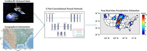
Reliable near real-time precipitation estimates are essential for monitoring and managing of natural disasters such as floods. Quality of inputs and capability of the retrieval algorithm are two important aspects for developing satellite-based precipitation datasets. Most retrieval algorithms utilize infrared (IR) information as their input due to its fine spatiotemporal resolution and near-instantaneous availability. However, their sole reliance on IR information limits their capability to learn different mechanisms of precipitation during training, resulting in less accurate estimates. Moreover, recent advances in the field of machine learning offer attractive opportunities to improve the precipitation retrieval algorithms. This study investigates the effectiveness of adding geographical information (i.e. latitude and longitude) to IR information and the application of a U-Net-based convolutional neural network for improving the accuracy of retrieval algorithms. This research suggests that applying an appropriate CNN architecture on geographical and IR information provides an opportunity to improve the satellite-based precipitation products.
中文翻译:
使用U-Net卷积神经网络和地理信息来改善近实时降水估算
可靠的近实时降水估算对于监控和管理洪水等自然灾害至关重要。输入质量和检索算法的能力是开发基于卫星的降水数据集的两个重要方面。由于其精细的时空分辨率和近乎瞬时的可用性,大多数检索算法都将红外(IR)信息用作其输入。但是,他们仅依靠红外信息限制了他们在训练过程中学习不同降水机制的能力,从而导致估算的准确性降低。此外,机器学习领域的最新进展为改进降水检索算法提供了诱人的机会。这项研究调查了添加地理信息的有效性(即 纬度和经度)以及基于U-Net的卷积神经网络在提高检索算法准确性方面的应用。这项研究表明,在地理和IR信息上应用适当的CNN体系结构可提供改善基于卫星的降水产品的机会。


 京公网安备 11010802027423号