当前位置:
X-MOL 学术
›
Earth Surf.Process. Land.
›
论文详情
Our official English website, www.x-mol.net, welcomes your
feedback! (Note: you will need to create a separate account there.)
Understanding historical coastal spit evolution: A case study from Spurn, East Yorkshire, UK
Earth Surface Processes and Landforms ( IF 2.8 ) Pub Date : 2020-08-28 , DOI: 10.1002/esp.4991 Mark D. Bateman 1 , Kaylee McHale 1 , Helen J. Bayntun 1 , Nick Williams 2
Earth Surface Processes and Landforms ( IF 2.8 ) Pub Date : 2020-08-28 , DOI: 10.1002/esp.4991 Mark D. Bateman 1 , Kaylee McHale 1 , Helen J. Bayntun 1 , Nick Williams 2
Affiliation

|
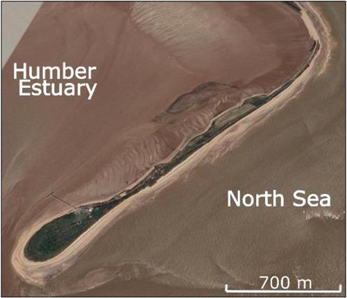
Globally sandy coastlines are threatened by erosion driven by climatic changes and increased storminess. Understanding how they have responded to past storms is key to help manage future coastal changes. Coastal spits around the world are particularly dynamic and therefore potentially vulnerable coastal features. Therefore, how they have evolved over the last few centuries is of great importance. To illustrate this, this study focuses on the historical evolution of a spit at Spurn on the east coast of the UK, which currently provides critical protection to settlements within the Humber estuary. Through the combination of digitized historical mapping and luminescence dating, this study shows that Spurn has been a consistent coastal feature over at least the past 440 years. No significant westward migration was observed for the last 200 years. Results show a long‐term extension of the spit and a decrease in its overall area, particularly in the last 50 years. Breaches of the neck cause temporary sediment pathway changes enabling westward extension of the head. Use of digitized historical maps in GIS combined with OSL dating has allowed a more complete understanding of long‐term spit evolution and sediment transport modes at Spurn. In doing so it helps inform future possible changes linked to pressures, such as increases in storm events and sea‐level rise. © 2020 The Authors. Earth Surface Processes and Landforms published by John Wiley & Sons Ltd
中文翻译:

了解沿海吐痰的历史演变:以英国东约克郡斯普恩市为例
全球沙质海岸线受到气候变化和暴风雨加剧驱动的侵蚀的威胁。了解他们如何应对过去的风暴是帮助管理未来沿海变化的关键。世界各地的沿海口特别活跃,因此可能具有脆弱的沿海特征。因此,它们在过去几个世纪中的发展非常重要。为了说明这一点,本研究着眼于英国东海岸Spurn吐痰的历史演变,目前该吐痰为亨伯河口内的定居点提供了重要保护。通过数字化历史地图和发光测年的结合,这项研究表明,至少在过去440年中,Spurn一直是沿海地区的特征。在过去的200年中,没有观察到明显的向西迁移。结果表明,唾液长期扩展,其总面积减少,尤其是在最近的50年中。颈部的松动会导致临时的沉积物路径改变,从而使头部向西延伸。在GIS中使用数字化历史地图并结合OSL测年可以更全面地了解Spurn的长期吐痰演变和沉积物迁移模式。这样做有助于告知未来与压力有关的可能变化,例如暴风雨事件的增加和海平面的上升。©2020作者。约翰·威利父子有限公司出版的《地球表面过程和地形》在GIS中使用数字化历史地图并结合OSL测年可以更全面地了解Spurn的长期吐痰演变和沉积物传输模式。这样做有助于告知未来与压力有关的可能变化,例如暴风雨事件的增加和海平面的上升。©2020作者。约翰·威利父子有限公司出版的《地球表面过程和地形》在GIS中使用数字化历史地图并结合OSL测年可以更全面地了解Spurn的长期吐痰演变和沉积物传输模式。这样做有助于告知未来与压力有关的可能变化,例如暴风雨事件的增加和海平面的上升。©2020作者。约翰·威利父子有限公司出版的《地球表面过程和地形》
更新日期:2020-11-03
中文翻译:

了解沿海吐痰的历史演变:以英国东约克郡斯普恩市为例
全球沙质海岸线受到气候变化和暴风雨加剧驱动的侵蚀的威胁。了解他们如何应对过去的风暴是帮助管理未来沿海变化的关键。世界各地的沿海口特别活跃,因此可能具有脆弱的沿海特征。因此,它们在过去几个世纪中的发展非常重要。为了说明这一点,本研究着眼于英国东海岸Spurn吐痰的历史演变,目前该吐痰为亨伯河口内的定居点提供了重要保护。通过数字化历史地图和发光测年的结合,这项研究表明,至少在过去440年中,Spurn一直是沿海地区的特征。在过去的200年中,没有观察到明显的向西迁移。结果表明,唾液长期扩展,其总面积减少,尤其是在最近的50年中。颈部的松动会导致临时的沉积物路径改变,从而使头部向西延伸。在GIS中使用数字化历史地图并结合OSL测年可以更全面地了解Spurn的长期吐痰演变和沉积物迁移模式。这样做有助于告知未来与压力有关的可能变化,例如暴风雨事件的增加和海平面的上升。©2020作者。约翰·威利父子有限公司出版的《地球表面过程和地形》在GIS中使用数字化历史地图并结合OSL测年可以更全面地了解Spurn的长期吐痰演变和沉积物传输模式。这样做有助于告知未来与压力有关的可能变化,例如暴风雨事件的增加和海平面的上升。©2020作者。约翰·威利父子有限公司出版的《地球表面过程和地形》在GIS中使用数字化历史地图并结合OSL测年可以更全面地了解Spurn的长期吐痰演变和沉积物传输模式。这样做有助于告知未来与压力有关的可能变化,例如暴风雨事件的增加和海平面的上升。©2020作者。约翰·威利父子有限公司出版的《地球表面过程和地形》


 京公网安备 11010802027423号