当前位置:
X-MOL 学术
›
Earth Surf.Process. Land.
›
论文详情
Our official English website, www.x-mol.net, welcomes your
feedback! (Note: you will need to create a separate account there.)
Talus slope geomorphology investigated at multiple time scales from high‐resolution topographic surveys and historical aerial photographs (Sanetsch Pass, Switzerland)
Earth Surface Processes and Landforms ( IF 2.8 ) Pub Date : 2020-08-27 , DOI: 10.1002/esp.4989 Hanne Hendrickx 1 , Lars De Sloover 1 , Cornelis Stal 1, 2 , Reynald Delaloye 3 , Jan Nyssen 1 , Amaury Frankl 1
Earth Surface Processes and Landforms ( IF 2.8 ) Pub Date : 2020-08-27 , DOI: 10.1002/esp.4989 Hanne Hendrickx 1 , Lars De Sloover 1 , Cornelis Stal 1, 2 , Reynald Delaloye 3 , Jan Nyssen 1 , Amaury Frankl 1
Affiliation
|
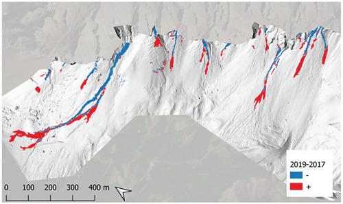
Talus slopes are common places for debris storage in high‐mountain environments and form an important step in the alpine sediment cascade. To understand slope instabilities and sediment transfers, detailed investigations of talus slope geomorphology are needed. Therefore, this study presents a detailed analysis of a talus slope on Col du Sanetsch (Swiss Alps), which is investigated at multiple time scales using high‐resolution topographic (HRT) surveys and historical aerial photographs. HRT surveys were collected during three consecutive summers (2017–2019), using uncrewed aerial vehicle (UAV) and terrestrial laser scanning (TLS) measurements. To date, very few studies exist that use HRT methods on talus slopes, especially to the extent of our study area (2 km2). Data acquisition from ground control and in situ field observations is challenging on a talus slope due to the steep terrain (30–37°) and high surface roughness. This results in a poor spatial distribution of ground control points (GCPs), causing unwanted deformation of up to 2 m in the gathered UAV‐derived HRT data. The co‐alignment of UAV imagery from different survey dates improved this deformation significantly, as validated by the TLS data. Sediment transfer is dominated by small‐scale but widespread snow push processes. Pre‐existing debris flow channels are prone to erosion and redeposition of material within the channel. A debris flow event of high magnitude occurred in the summer of 2019, as a result of several convective thunderstorms. While low‐magnitude (<5,000 m3) debris flow events are frequent throughout the historical record with a return period of 10–20 years, this 2019 event exceeded all historical debris flow events since 1946 in both extent and volume. Future climate predictions show an increase of such intense precipitation events in the region, potentially altering the frequency of debris flows in the study area and changing the dominant geomorphic process which are active on such talus slopes. © 2020 John Wiley & Sons, Ltd.
中文翻译:

从高分辨率地形调查和历史航拍照片中,在多个时间尺度上调查了距骨斜坡地貌(瑞士萨内奇山口)
距骨斜坡是高山区环境中常见的碎屑储存场所,是高山沉积物梯级的重要一步。为了了解边坡的不稳定性和沉积物的转移,需要对距骨边坡地貌进行详细的研究。因此,本研究提供了对Col du Sanetsch(瑞士阿尔卑斯山)的距骨坡度的详细分析,可使用高分辨率地形(HRT)调查和历史航空照片在多个时间尺度上对其进行调查。HRT调查是在连续三个夏天(2017-2019年)期间使用无人驾驶飞机(UAV)和地面激光扫描(TLS)测量进行的。迄今为止,很少有研究在距骨斜坡上使用HRT方法,特别是在我们研究区域(2 km 2)。由于陡峭的地形(30-37°)和高的表面粗糙度,在距骨坡度上,从地面控制和现场观察获得的数据具有挑战性。这导致地面控制点(GCP)的空间分布不佳,从而导致在收集的无人机衍生的HRT数据中产生高达2 m的意外变形。TLS数据证实,来自不同调查日期的无人机影像的共对准显着改善了这种变形。泥沙转移以小规模但普遍的积雪过程为主。预先存在的泥石流通道容易腐蚀和重新沉积通道内的材料。由于几次对流雷暴,2019年夏季发生了一次高泥石流事件。低幅(<5,000 m 3)泥石流事件在整个历史记录中屡见不鲜,返回期为10-20年,该事件在规模和数量上都超过了1946年以来的所有历史泥石流事件。未来的气候预测表明,该地区这种强烈的降水事件增加了,有可能改变研究区泥石流的频率,并改变活跃在此类距骨斜坡上的主要地貌过程。分级为4 +©2020 John Wiley&Sons,Ltd.
更新日期:2020-11-03
中文翻译:
从高分辨率地形调查和历史航拍照片中,在多个时间尺度上调查了距骨斜坡地貌(瑞士萨内奇山口)
距骨斜坡是高山区环境中常见的碎屑储存场所,是高山沉积物梯级的重要一步。为了了解边坡的不稳定性和沉积物的转移,需要对距骨边坡地貌进行详细的研究。因此,本研究提供了对Col du Sanetsch(瑞士阿尔卑斯山)的距骨坡度的详细分析,可使用高分辨率地形(HRT)调查和历史航空照片在多个时间尺度上对其进行调查。HRT调查是在连续三个夏天(2017-2019年)期间使用无人驾驶飞机(UAV)和地面激光扫描(TLS)测量进行的。迄今为止,很少有研究在距骨斜坡上使用HRT方法,特别是在我们研究区域(2 km 2)。由于陡峭的地形(30-37°)和高的表面粗糙度,在距骨坡度上,从地面控制和现场观察获得的数据具有挑战性。这导致地面控制点(GCP)的空间分布不佳,从而导致在收集的无人机衍生的HRT数据中产生高达2 m的意外变形。TLS数据证实,来自不同调查日期的无人机影像的共对准显着改善了这种变形。泥沙转移以小规模但普遍的积雪过程为主。预先存在的泥石流通道容易腐蚀和重新沉积通道内的材料。由于几次对流雷暴,2019年夏季发生了一次高泥石流事件。低幅(<5,000 m 3)泥石流事件在整个历史记录中屡见不鲜,返回期为10-20年,该事件在规模和数量上都超过了1946年以来的所有历史泥石流事件。未来的气候预测表明,该地区这种强烈的降水事件增加了,有可能改变研究区泥石流的频率,并改变活跃在此类距骨斜坡上的主要地貌过程。分级为4 +©2020 John Wiley&Sons,Ltd.


 京公网安备 11010802027423号