当前位置:
X-MOL 学术
›
Landsc. Urban Plan.
›
论文详情
Our official English website, www.x-mol.net, welcomes your
feedback! (Note: you will need to create a separate account there.)
Remote sensing in urban planning: Contributions towards ecologically sound policies?
Landscape and Urban Planning ( IF 7.9 ) Pub Date : 2020-12-01 , DOI: 10.1016/j.landurbplan.2020.103921 Thilo Wellmann , Angela Lausch , Erik Andersson , Sonja Knapp , Chiara Cortinovis , Jessica Jache , Sebastian Scheuer , Peleg Kremer , André Mascarenhas , Roland Kraemer , Annegret Haase , Franz Schug , Dagmar Haase
Landscape and Urban Planning ( IF 7.9 ) Pub Date : 2020-12-01 , DOI: 10.1016/j.landurbplan.2020.103921 Thilo Wellmann , Angela Lausch , Erik Andersson , Sonja Knapp , Chiara Cortinovis , Jessica Jache , Sebastian Scheuer , Peleg Kremer , André Mascarenhas , Roland Kraemer , Annegret Haase , Franz Schug , Dagmar Haase
|
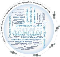
Abstract Remote sensing has evolved to become a key tool for various fields of environmental analysis, thus actively informing policy across areas and domains. To evaluate the degree to which remote sensing is contributing to the science of ecologically-oriented urban planning, we carried out a systematic literature review using the SCOPUS database, searching for articles integrating knowledge in urban planning, remote sensing and ecology. We reviewed 186 articles, analysing various issues in urban environments worldwide. Key findings include that the level of integration between the three disciplines is limited, with only 12% of the papers fully integrating ecology, remote sensing and planning while 24% of the studies use specific methods from one domain only. The vast majority of studies is oriented towards contributing to the knowledge base or monitoring the impacts of existing policies. Few studies are directly policy relevant by either contributing to direct issues in planning and making specific design suggestions or evaluations. The accessibility of the scientific findings remains limited, as the majority of journal articles are not open access and proprietary software and data are frequently used. To overcome these issues, we suggest three future avenues for science as well as three potential entry points for remote sensing into applied urban planning. By doing so, remote sensing data could become a vital tool actively contributing to policies, civil engagement and concrete planning measures by providing independent and cost effective environmental analyses.
中文翻译:

城市规划中的遥感:对生态无害政策的贡献?
摘要 遥感已经发展成为环境分析各个领域的关键工具,从而积极地为跨领域和领域的政策提供信息。为了评估遥感对以生态为导向的城市规划科学的贡献程度,我们使用 SCOPUS 数据库进行了系统的文献回顾,搜索整合了城市规划、遥感和生态学知识的文章。我们回顾了 186 篇文章,分析了全球城市环境中的各种问题。主要发现包括三个学科之间的整合水平有限,只有 12% 的论文完全整合了生态学、遥感和规划,而 24% 的研究仅使用了一个领域的特定方法。绝大多数研究都致力于为知识库做出贡献或监测现有政策的影响。很少有研究通过对规划中的直接问题做出贡献以及提出具体的设计建议或评估来与政策直接相关。科学发现的可访问性仍然有限,因为大多数期刊文章都不是开放获取的,并且经常使用专有软件和数据。为了克服这些问题,我们提出了三个未来的科学途径以及遥感应用城市规划的三个潜在切入点。通过这样做,遥感数据可以通过提供独立且具有成本效益的环境分析,成为积极促进政策、民间参与和具体规划措施的重要工具。
更新日期:2020-12-01
中文翻译:
城市规划中的遥感:对生态无害政策的贡献?
摘要 遥感已经发展成为环境分析各个领域的关键工具,从而积极地为跨领域和领域的政策提供信息。为了评估遥感对以生态为导向的城市规划科学的贡献程度,我们使用 SCOPUS 数据库进行了系统的文献回顾,搜索整合了城市规划、遥感和生态学知识的文章。我们回顾了 186 篇文章,分析了全球城市环境中的各种问题。主要发现包括三个学科之间的整合水平有限,只有 12% 的论文完全整合了生态学、遥感和规划,而 24% 的研究仅使用了一个领域的特定方法。绝大多数研究都致力于为知识库做出贡献或监测现有政策的影响。很少有研究通过对规划中的直接问题做出贡献以及提出具体的设计建议或评估来与政策直接相关。科学发现的可访问性仍然有限,因为大多数期刊文章都不是开放获取的,并且经常使用专有软件和数据。为了克服这些问题,我们提出了三个未来的科学途径以及遥感应用城市规划的三个潜在切入点。通过这样做,遥感数据可以通过提供独立且具有成本效益的环境分析,成为积极促进政策、民间参与和具体规划措施的重要工具。


 京公网安备 11010802027423号