当前位置:
X-MOL 学术
›
Earth Surf.Process. Land.
›
论文详情
Our official English website, www.x-mol.net, welcomes your
feedback! (Note: you will need to create a separate account there.)
Process inference from topographic fractal characteristics in the tectonically active Northwest Himalaya, India
Earth Surface Processes and Landforms ( IF 2.8 ) Pub Date : 2020-08-24 , DOI: 10.1002/esp.4984 Ramendra Sahoo 1 , R.N. Singh 1 , Vikrant Jain 1
Earth Surface Processes and Landforms ( IF 2.8 ) Pub Date : 2020-08-24 , DOI: 10.1002/esp.4984 Ramendra Sahoo 1 , R.N. Singh 1 , Vikrant Jain 1
Affiliation
|
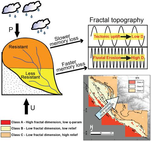
Topography evolves under the coupled effect of exogenic and endogenic governing factors, and their scale‐(in)variant dynamics. This results in a self‐affine topography across a finite range, with a characteristic fractal dimension. Fractal analysis has been used to classify geological terrains having distinct litho‐tectonic settings. However, process‐based understanding of the fractal behaviour of a natural landscape is still limited. The current study aims to substantiate and expand upon the present knowledge of topographic response to the complex actions of the governing factors using fractal characteristics. We examined the association between the litho‐tectonic, climatic settings and the fractal characteristics of the topography in the tectonically active Northwest Himalaya. Our analysis was carried out in three separate sectors having diverse litho‐tectonic settings. We used the roughness–length method to calculate the fractal parameters (fractal dimension, D; ordinate intercept, q). The Higher and the Lesser Himalaya were found to be characterized by low D and high q, while the tectonically active Sub Himalaya was found to have moderate D and low q. The southernmost foreland alluvial plains were characterized by high D and low q. Clusters of the fractal parameters were found to be consistent in spatial pattern across the three sectors. Our results showed that the geological–geomorphological settings and the associated processes (e.g. uplift, erosion and diffusion) can be well inferred using the fractal characteristics of the topography. Further, our results implied first‐order control of lithology in sustaining and shaping the topographic geometry (both its amplitude and texture) in the tectonically active Northwest Himalaya. The spatial distribution of the fractal parameters also suggested the secondary control of tectonic uplift and, to a much lesser extent, mean annual rainfall on the topographic geometry. These results collectively point to the role of complex actions of the governing factors in the landscape evolution process. © 2020 John Wiley & Sons, Ltd.
中文翻译:

根据印度喜马拉雅西北构造活动的地形分形特征推断过程
地形是在外源性和内源性控制因素及其尺度(不变)动力学的耦合作用下演化的。这会在有限范围内形成自仿射形貌,并具有特征性的分形维数。分形分析已被用于对岩石构造背景不同的地质地形进行分类。但是,对基于自然景观的分形行为的基于过程的理解仍然是有限的。当前的研究旨在证实和扩展利用分形特征对控制因素的复杂作用进行地形响应的现有知识。我们研究了构造活跃的西北喜马拉雅山的岩石构造,气候环境与地形分形特征之间的联系。我们的分析是在三个不同的岩石构造背景不同的领域进行的。我们使用了粗糙度-长度方法来计算分形参数(分形维数,D ; 纵坐标截距q)。高喜马拉雅山和小喜马拉雅山的特征是低D和高q,而活跃构造的Sub Himalaya被发现具有中等D和低q。最南端的前陆冲积平原的特征是高D和低q。发现分形参数的簇在三个扇区的空间格局上是一致的。我们的结果表明,利用地形的分形特征可以很好地推断出地质-地貌环境及其相关过程(例如隆升,侵蚀和扩散)。此外,我们的研究结果暗示了在构造活动活跃的喜马拉雅山西北地区,在维持和塑造地形几何形状(振幅和纹理)方面对岩性进行了一级控制。分形参数的空间分布也暗示了构造隆升的次生控制,并且在较小程度上还表明了地形几何上的年平均降雨量。这些结果共同指出了控制因素在景观演化过程中的复杂作用。©2020 John Wiley&Sons,Ltd.
更新日期:2020-08-24
中文翻译:
根据印度喜马拉雅西北构造活动的地形分形特征推断过程
地形是在外源性和内源性控制因素及其尺度(不变)动力学的耦合作用下演化的。这会在有限范围内形成自仿射形貌,并具有特征性的分形维数。分形分析已被用于对岩石构造背景不同的地质地形进行分类。但是,对基于自然景观的分形行为的基于过程的理解仍然是有限的。当前的研究旨在证实和扩展利用分形特征对控制因素的复杂作用进行地形响应的现有知识。我们研究了构造活跃的西北喜马拉雅山的岩石构造,气候环境与地形分形特征之间的联系。我们的分析是在三个不同的岩石构造背景不同的领域进行的。我们使用了粗糙度-长度方法来计算分形参数(分形维数,D ; 纵坐标截距q)。高喜马拉雅山和小喜马拉雅山的特征是低D和高q,而活跃构造的Sub Himalaya被发现具有中等D和低q。最南端的前陆冲积平原的特征是高D和低q。发现分形参数的簇在三个扇区的空间格局上是一致的。我们的结果表明,利用地形的分形特征可以很好地推断出地质-地貌环境及其相关过程(例如隆升,侵蚀和扩散)。此外,我们的研究结果暗示了在构造活动活跃的喜马拉雅山西北地区,在维持和塑造地形几何形状(振幅和纹理)方面对岩性进行了一级控制。分形参数的空间分布也暗示了构造隆升的次生控制,并且在较小程度上还表明了地形几何上的年平均降雨量。这些结果共同指出了控制因素在景观演化过程中的复杂作用。©2020 John Wiley&Sons,Ltd.


 京公网安备 11010802027423号