当前位置:
X-MOL 学术
›
Meteorol. Appl.
›
论文详情
Our official English website, www.x-mol.net, welcomes your
feedback! (Note: you will need to create a separate account there.)
Assessing the performance of GPS tomography at retrieving water vapour fields during landfalling atmospheric rivers over southern California
Meteorological Applications ( IF 2.3 ) Pub Date : 2020-08-24 , DOI: 10.1002/met.1943 Biyan Chen 1, 2, 3 , Wenkun Yu 1, 2 , Wujiao Dai 1, 2 , Hao Wu 4 , Wei Wang 1, 2, 3
Meteorological Applications ( IF 2.3 ) Pub Date : 2020-08-24 , DOI: 10.1002/met.1943 Biyan Chen 1, 2, 3 , Wenkun Yu 1, 2 , Wujiao Dai 1, 2 , Hao Wu 4 , Wei Wang 1, 2, 3
Affiliation
|
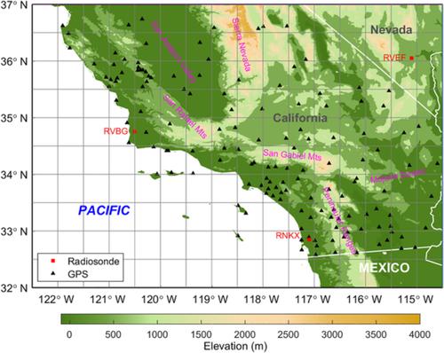
Accurate monitoring of water vapour evolution is essential to gain a better understanding of the atmospheric river movement, as well as predicting the severity and life cycle of heavy precipitation. The use of hundreds of ground Global Positioning System (GPS) stations in southern California provided a good opportunity to monitor the water vapour changes associated with landfalling atmospheric rivers. Based on a tomographic technique, the 15 min‐resolution water vapour density fields of southern California were reconstructed for February 2019. The assessments by radiosonde and the European Centre for Medium‐Range Weather Forecasts' (ECMWF) Re‐Analysis Interim (ERA‐Interim) database reanalysis show that tomography can retrieve the density profiles with an overall accuracy of about 1.1 g·m–3. In addition, both assessments indicate that the tomographic solutions of altitudes > 6 km are not reliable as relative root mean square error can reach up to 500% in the uppermost layer. Nevertheless, tomographic integrated water vapour is consistent with those derived from radiosonde and ERA‐Interim because their discrepancies are basically < 3 mm. The tomographic density fields were then applied to monitor water vapour evolution associated with two atmospheric river landfalls that occurred on February 2 and February 13, 2019. Results show that both atmospheric rivers made landfall from the northwest and passed over southern California in a southeasterly direction. The series of density profiles reveals that the high‐elevation mountains can block the atmospheric river movement, resulting in the concentration of water vapour at the foot of the mountains.
中文翻译:

评估GPS层析成像在检索加利福尼亚南部上空大气河流中的水汽场方面的性能
准确监测水蒸气的释放对于更好地了解大气中的河流运动以及预测强降水的严重程度和生命周期至关重要。在加利福尼亚南部使用数百个地面全球定位系统(GPS)站提供了一个很好的机会来监视与登陆大气河有关的水蒸气变化。基于层析成像技术,于2019年2月重建了南加州15分钟分辨率的水蒸气密度场。无线电探空仪和欧洲中距离天气预报中心(ECMWF)的重新分析中期评估(ERA-Interim)进行了评估。 )数据库的重新分析表明,层析成像可以以大约1.1 g·m –3的整体精度检索密度分布图。此外,两项评估均表明,海拔> 6 km的层析成像解决方案并不可靠,因为相对的均方根误差在最上层可能高达500%。但是,层析X射线综合水蒸气与从探空仪和ERA-Interim获得的水蒸气相一致,因为它们的差异基本上<3 mm。然后,将层析密度场应用于监测与发生在2019年2月2日和2019年2月13日的两次大气河登陆有关的水蒸气的演变。结果显示,两条大气河都从西北登陆,并以东南方向穿过加利福尼亚南部。这一系列的密度剖面表明,高海拔山脉会阻碍大气河流的运动,
更新日期:2020-08-24
中文翻译:
评估GPS层析成像在检索加利福尼亚南部上空大气河流中的水汽场方面的性能
准确监测水蒸气的释放对于更好地了解大气中的河流运动以及预测强降水的严重程度和生命周期至关重要。在加利福尼亚南部使用数百个地面全球定位系统(GPS)站提供了一个很好的机会来监视与登陆大气河有关的水蒸气变化。基于层析成像技术,于2019年2月重建了南加州15分钟分辨率的水蒸气密度场。无线电探空仪和欧洲中距离天气预报中心(ECMWF)的重新分析中期评估(ERA-Interim)进行了评估。 )数据库的重新分析表明,层析成像可以以大约1.1 g·m –3的整体精度检索密度分布图。此外,两项评估均表明,海拔> 6 km的层析成像解决方案并不可靠,因为相对的均方根误差在最上层可能高达500%。但是,层析X射线综合水蒸气与从探空仪和ERA-Interim获得的水蒸气相一致,因为它们的差异基本上<3 mm。然后,将层析密度场应用于监测与发生在2019年2月2日和2019年2月13日的两次大气河登陆有关的水蒸气的演变。结果显示,两条大气河都从西北登陆,并以东南方向穿过加利福尼亚南部。这一系列的密度剖面表明,高海拔山脉会阻碍大气河流的运动,


 京公网安备 11010802027423号