当前位置:
X-MOL 学术
›
Earth Surf.Process. Land.
›
论文详情
Our official English website, www.x-mol.net, welcomes your
feedback! (Note: you will need to create a separate account there.)
Landslide‐dammed lake sediment volume calculation using waterborne ERT and SONAR profiling
Earth Surface Processes and Landforms ( IF 2.8 ) Pub Date : 2020-08-13 , DOI: 10.1002/esp.4977 Filip Hartvich 1, 2 , Petr Tábořík 1, 2 , Miroslav Šobr 1 , Bohumír Janský 1 , Zdeněk Kliment 1 , Jakub Langhammer 1
Earth Surface Processes and Landforms ( IF 2.8 ) Pub Date : 2020-08-13 , DOI: 10.1002/esp.4977 Filip Hartvich 1, 2 , Petr Tábořík 1, 2 , Miroslav Šobr 1 , Bohumír Janský 1 , Zdeněk Kliment 1 , Jakub Langhammer 1
Affiliation
|
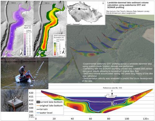
Lake sediment volume calculation is a challenging task, namely in cases when detailed drilling is complicated, expensive, or impossible, information on the pre‐sedimentation surface unavailable, and record of siltation rate non‐existent or too short. This study shows how waterborne, non‐invasive geophysical survey, such as electrical resistivity tomography (ERT) can be very effective in acquiring the missing data, namely when combined with sound navigation ranging (SONAR) water depth measurements and supported by information from auxiliary sources. However, ERT surveying in water environment requires specific approaches, as we illustrate on the case of the Mladotice lake study. The lake was created after a landslide in May 1872, and since its formation, the depth has gradually decreased due to sedimentation. We have reconstructed the original surface, calculated the sediment volume, and compiled information on sedimentation to estimate its remaining life span. To achieve this, we measured nine waterborne ERT profiles across the lake. To reach the necessary depth, all ERT profiles were extended on land and crossed the lake using custom‐built flotation pads. ERT profiling was combined with SONAR depth measurements, historical bathymetric surveys, borehole core analysis, sediment flux measurements, volumetric calculations, and water conductivity probing. The study has achieved three main results. First, practical applicability and advantages of stationary waterborne ERT profiling in combination with bathymetric sounding were demonstrated. Second, the original lake volume and accumulated sediment was calculated. We estimate that the volume of lake sediment is 187 000 m3, two‐thirds of the original lake volume (over 275 000 m3). Finally, based on three volumetric data sets from 1972, 2003, and 2017, and recent monitoring of the sediment inflow, we propose scenarios of lake filling and its future development. Most interestingly, the sedimentation rate has decreased significantly in the last 20 years, suggesting that the lake may survive much longer than hitherto expected. © 2020 John Wiley & Sons, Ltd.
中文翻译:

利用水基ERT和SONAR分析计算滑坡坝的湖泊沉积物量
湖泊沉积物体积的计算是一项艰巨的任务,即在详细钻探复杂,昂贵或不可能的情况下,无法获得有关沉积前表面的信息,并且泥沙淤积率的记录将不存在或太短。这项研究显示了水性无创地球物理勘测(例如电阻层析成像(ERT))如何非常有效地获取丢失的数据,即与声音导航测距(SONAR)水深测量结合并得到辅助来源信息的支持。但是,正如我们在Mladotice湖研究中所举例说明的那样,水环境中的ERT调查需要特定的方法。该湖是在1872年5月发生山体滑坡之后形成的,自形成以来,由于沉积作用,其深度逐渐减小。我们已经重建了原始表面,计算了泥沙量,并收集了有关泥沙的信息以估计其剩余寿命。为了实现这一目标,我们测量了整个湖水的9个水性ERT剖面。为了达到必要的深度,所有ERT配置文件都在陆地上延伸,并使用定制的浮垫跨过湖面。ERT分析与SONAR深度测量,历史测深调查,钻孔岩心分析,沉积物通量测量,体积计算和水电导率探测相结合。该研究取得了三个主要结果。首先,展示了固定水基ERT分析与测深探测相结合的实际适用性和优点。其次,计算了原始湖泊的体积和沉积物。3,原湖体积的三分之二(超过275000米3)。最后,基于1972年,2003年和2017年的三个体积数据集,以及最近对沉积物流入的监测,我们提出了湖泊充填及其未来发展的方案。最有趣的是,在过去20年中,沉积速率已显着下降,这表明该湖的生存时间可能比迄今为止的预期更长。分级为4 +©2020 John Wiley&Sons,Ltd.
更新日期:2020-08-13
中文翻译:
利用水基ERT和SONAR分析计算滑坡坝的湖泊沉积物量
湖泊沉积物体积的计算是一项艰巨的任务,即在详细钻探复杂,昂贵或不可能的情况下,无法获得有关沉积前表面的信息,并且泥沙淤积率的记录将不存在或太短。这项研究显示了水性无创地球物理勘测(例如电阻层析成像(ERT))如何非常有效地获取丢失的数据,即与声音导航测距(SONAR)水深测量结合并得到辅助来源信息的支持。但是,正如我们在Mladotice湖研究中所举例说明的那样,水环境中的ERT调查需要特定的方法。该湖是在1872年5月发生山体滑坡之后形成的,自形成以来,由于沉积作用,其深度逐渐减小。我们已经重建了原始表面,计算了泥沙量,并收集了有关泥沙的信息以估计其剩余寿命。为了实现这一目标,我们测量了整个湖水的9个水性ERT剖面。为了达到必要的深度,所有ERT配置文件都在陆地上延伸,并使用定制的浮垫跨过湖面。ERT分析与SONAR深度测量,历史测深调查,钻孔岩心分析,沉积物通量测量,体积计算和水电导率探测相结合。该研究取得了三个主要结果。首先,展示了固定水基ERT分析与测深探测相结合的实际适用性和优点。其次,计算了原始湖泊的体积和沉积物。3,原湖体积的三分之二(超过275000米3)。最后,基于1972年,2003年和2017年的三个体积数据集,以及最近对沉积物流入的监测,我们提出了湖泊充填及其未来发展的方案。最有趣的是,在过去20年中,沉积速率已显着下降,这表明该湖的生存时间可能比迄今为止的预期更长。分级为4 +©2020 John Wiley&Sons,Ltd.


 京公网安备 11010802027423号