当前位置:
X-MOL 学术
›
Remote Sens. Environ.
›
论文详情
Our official English website, www.x-mol.net, welcomes your
feedback! (Note: you will need to create a separate account there.)
Unitemporal approach to fire severity mapping using multispectral synthetic databases and Random Forests
Remote Sensing of Environment ( IF 11.1 ) Pub Date : 2020-11-01 , DOI: 10.1016/j.rse.2020.112025 Raquel Montorio , Fernando Pérez-Cabello , Daniel Borini Alves , Alberto García-Martín
Remote Sensing of Environment ( IF 11.1 ) Pub Date : 2020-11-01 , DOI: 10.1016/j.rse.2020.112025 Raquel Montorio , Fernando Pérez-Cabello , Daniel Borini Alves , Alberto García-Martín
|
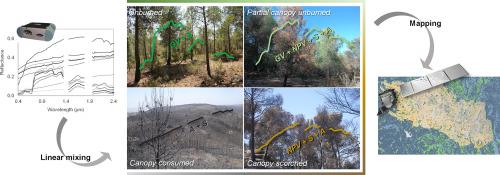
Abstract Fire severity assessment is crucial for predicting ecosystem response and prioritizing post-fire forest management strategies. Although a variety of remote sensing approaches have been developed, more research is still needed to improve the accuracy and effectiveness of fire severity mapping. This study proposes a unitemporal simulation approach based on the generation of synthetic spectral databases from linear spectral mixing. To fully exploit the potential of these training databases, the Random Forest (RF) machine learning algorithm was applied to build a classifier and regression model. The predictive models parameterized with the synthetic datasets were applied in a case study, the Sierra de Luna wildfire in Spain. Single date Landsat-8 and Sentinel-2A imagery of the immediate post-fire environment were used to develop the validation spectral datasets and a Pleiades orthoimage, providing the ground truth data. The four defined severity categories – unburned (UB), partial canopy unburned (PCU), canopy scorched (CS), and canopy consumed (CC) – demonstrated high accuracy in the bootstrapped (about 95%) and real validation sets (about 90%), with a slightly better performance observed when the Sentinel-2A dataset was used. Abundance of four ground covers (green vegetation, non-photosynthetic vegetation, soil, and ash) was also quantified with moderate (~45% for NPV) or high accuracy (higher than 75% for the remaining covers). No specific pattern in the comparison of sensors was observed. Variable importance analysis highlighted the complementary behavior of the spectral bands, although the contrast between the near and shortwave infrared regions stood out above the rest. Comparison of procedures reinforced the usefulness of the approach, as RF image-derived models and the multiple endmember spectral unmixing technique (MESMA) showed lower accuracy. The capabilities for detailed mapping are reflected in the development of different types of cartography (classification maps and fraction cover maps). The approach holds great potential for fire severity assessment, and future research needs to extend the predictive modeling to other burned areas – also in different ecosystems – and analyze its competence and the possible adaptations needed.
中文翻译:

使用多光谱合成数据库和随机森林进行火灾严重程度映射的单时方法
摘要 火灾严重程度评估对于预测生态系统响应和确定火灾后森林管理策略的优先顺序至关重要。尽管已经开发了多种遥感方法,但仍需要更多的研究来提高火灾严重程度图的准确性和有效性。本研究提出了一种基于从线性光谱混合生成合成光谱数据库的单时模拟方法。为了充分利用这些训练数据库的潜力,应用随机森林 (RF) 机器学习算法来构建分类器和回归模型。使用合成数据集参数化的预测模型应用于案例研究,即西班牙的 Sierra de Luna 野火。火灾后即时环境的单日期 Landsat-8 和 Sentinel-2A 图像用于开发验证光谱数据集和昴宿星正射影像,提供地面实况数据。四个定义的严重性类别——未燃烧 (UB)、部分未燃烧 (PCU)、冠层烧焦 (CS) 和冠层消耗 (CC)——在自举 (约 95%) 和真实验证集 (约 90%) 中表现出很高的准确性),使用 Sentinel-2A 数据集时观察到的性能稍好。四种地面覆盖物(绿色植被、非光合植被、土壤和灰烬)的丰度也被量化为中等(NPV 约 45%)或高精度(其余覆盖物高于 75%)。没有观察到传感器比较中的特定模式。变量重要性分析突出了光谱带的互补行为,尽管近波和短波红外区域之间的对比明显高于其他区域。程序的比较增强了该方法的实用性,因为 RF 图像衍生模型和多端元光谱分离技术 (MESMA) 显示出较低的精度。详细制图的能力反映在不同类型制图(分类图和分数覆盖图)的开发中。该方法在火灾严重性评估方面具有巨大潜力,未来的研究需要将预测模型扩展到其他燃烧区域——也在不同的生态系统中——并分析其能力和可能需要的适应性。尽管近波和短波红外区域之间的对比明显高于其他区域。程序的比较增强了该方法的实用性,因为 RF 图像衍生模型和多端元光谱分离技术 (MESMA) 显示出较低的精度。详细制图的能力反映在不同类型制图(分类图和分数覆盖图)的开发中。该方法在火灾严重性评估方面具有巨大潜力,未来的研究需要将预测模型扩展到其他燃烧区域——也在不同的生态系统中——并分析其能力和可能需要的适应性。尽管近波和短波红外区域之间的对比明显高于其他区域。程序的比较增强了该方法的实用性,因为 RF 图像衍生模型和多端元光谱分离技术 (MESMA) 显示出较低的精度。详细制图的能力反映在不同类型制图(分类图和分数覆盖图)的开发中。该方法在火灾严重性评估方面具有巨大潜力,未来的研究需要将预测模型扩展到其他燃烧区域——也在不同的生态系统中——并分析其能力和可能需要的适应性。因为 RF 图像衍生模型和多端元光谱分离技术 (MESMA) 显示出较低的精度。详细制图的能力反映在不同类型制图(分类图和分数覆盖图)的开发中。该方法在火灾严重性评估方面具有巨大潜力,未来的研究需要将预测模型扩展到其他燃烧区域——也在不同的生态系统中——并分析其能力和可能需要的适应性。因为 RF 图像衍生模型和多端元光谱分离技术 (MESMA) 显示出较低的精度。详细制图的能力反映在不同类型制图(分类图和分数覆盖图)的开发中。该方法在火灾严重性评估方面具有巨大潜力,未来的研究需要将预测模型扩展到其他燃烧区域——也在不同的生态系统中——并分析其能力和可能需要的适应性。
更新日期:2020-11-01
中文翻译:
使用多光谱合成数据库和随机森林进行火灾严重程度映射的单时方法
摘要 火灾严重程度评估对于预测生态系统响应和确定火灾后森林管理策略的优先顺序至关重要。尽管已经开发了多种遥感方法,但仍需要更多的研究来提高火灾严重程度图的准确性和有效性。本研究提出了一种基于从线性光谱混合生成合成光谱数据库的单时模拟方法。为了充分利用这些训练数据库的潜力,应用随机森林 (RF) 机器学习算法来构建分类器和回归模型。使用合成数据集参数化的预测模型应用于案例研究,即西班牙的 Sierra de Luna 野火。火灾后即时环境的单日期 Landsat-8 和 Sentinel-2A 图像用于开发验证光谱数据集和昴宿星正射影像,提供地面实况数据。四个定义的严重性类别——未燃烧 (UB)、部分未燃烧 (PCU)、冠层烧焦 (CS) 和冠层消耗 (CC)——在自举 (约 95%) 和真实验证集 (约 90%) 中表现出很高的准确性),使用 Sentinel-2A 数据集时观察到的性能稍好。四种地面覆盖物(绿色植被、非光合植被、土壤和灰烬)的丰度也被量化为中等(NPV 约 45%)或高精度(其余覆盖物高于 75%)。没有观察到传感器比较中的特定模式。变量重要性分析突出了光谱带的互补行为,尽管近波和短波红外区域之间的对比明显高于其他区域。程序的比较增强了该方法的实用性,因为 RF 图像衍生模型和多端元光谱分离技术 (MESMA) 显示出较低的精度。详细制图的能力反映在不同类型制图(分类图和分数覆盖图)的开发中。该方法在火灾严重性评估方面具有巨大潜力,未来的研究需要将预测模型扩展到其他燃烧区域——也在不同的生态系统中——并分析其能力和可能需要的适应性。尽管近波和短波红外区域之间的对比明显高于其他区域。程序的比较增强了该方法的实用性,因为 RF 图像衍生模型和多端元光谱分离技术 (MESMA) 显示出较低的精度。详细制图的能力反映在不同类型制图(分类图和分数覆盖图)的开发中。该方法在火灾严重性评估方面具有巨大潜力,未来的研究需要将预测模型扩展到其他燃烧区域——也在不同的生态系统中——并分析其能力和可能需要的适应性。尽管近波和短波红外区域之间的对比明显高于其他区域。程序的比较增强了该方法的实用性,因为 RF 图像衍生模型和多端元光谱分离技术 (MESMA) 显示出较低的精度。详细制图的能力反映在不同类型制图(分类图和分数覆盖图)的开发中。该方法在火灾严重性评估方面具有巨大潜力,未来的研究需要将预测模型扩展到其他燃烧区域——也在不同的生态系统中——并分析其能力和可能需要的适应性。因为 RF 图像衍生模型和多端元光谱分离技术 (MESMA) 显示出较低的精度。详细制图的能力反映在不同类型制图(分类图和分数覆盖图)的开发中。该方法在火灾严重性评估方面具有巨大潜力,未来的研究需要将预测模型扩展到其他燃烧区域——也在不同的生态系统中——并分析其能力和可能需要的适应性。因为 RF 图像衍生模型和多端元光谱分离技术 (MESMA) 显示出较低的精度。详细制图的能力反映在不同类型制图(分类图和分数覆盖图)的开发中。该方法在火灾严重性评估方面具有巨大潜力,未来的研究需要将预测模型扩展到其他燃烧区域——也在不同的生态系统中——并分析其能力和可能需要的适应性。


 京公网安备 11010802027423号