当前位置:
X-MOL 学术
›
J. Afr. Earth Sci.
›
论文详情
Our official English website, www.x-mol.net, welcomes your
feedback! (Note: you will need to create a separate account there.)
Integrating of remote sensing, GIS and geophysical data for recharge potentiality evaluation in Wadi El Tarfa, eastern desert, Egypt
Journal of African Earth Sciences ( IF 2.2 ) Pub Date : 2020-12-01 , DOI: 10.1016/j.jafrearsci.2020.103957 Alaa A. Ahmed , Ashraf R. Shabana
Journal of African Earth Sciences ( IF 2.2 ) Pub Date : 2020-12-01 , DOI: 10.1016/j.jafrearsci.2020.103957 Alaa A. Ahmed , Ashraf R. Shabana
|
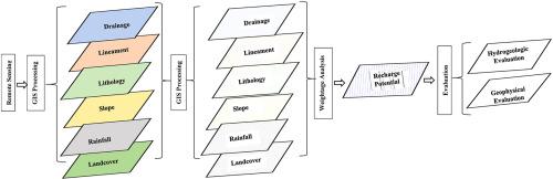
Abstract In Egypt, water resources management is considered a major socio-economic issue and a central component for future development. With the increasing rate of population growth, urbanization and agricultural expansion, groundwater resources are gaining more demand and attention. Wadi El Tarfa area is one of the semi-arid areas located in the Eastern Desert of Egypt, composed of Cretaceous and Eocene limestone and Quaternary sediments. This study focused on delineation, evaluation and verification of the groundwater potential zones using remote sensing, geospatial techniques and field work. In this regard, thematic maps of the contributing factors such as stream networks, lineaments, lithology, slope, landcover/landuse and rainfall were generated using the Geographic Information Systems (GIS) and Remote Sensing (RS) techniques. Based on the determined recharge favorability, weighing, and overlaying, a groundwater potential of the study area was prepared. The output recharge potential map shows three zones of groundwater prospective potential: good, moderate and low constituting 25%, 69% and 6% of the study area respectively. Of them, the high and moderate zones are strongly recommended for further exploration. The geophysical, water data and transmissivity data for some water points located within the targeted area confirmed the recommended zones. The overall results reflect the effectiveness of using the remote sensing data and geospatial techniques to target areas for groundwater exploration.
中文翻译:

将遥感、GIS 和地球物理数据集成到埃及东部沙漠 Wadi El Tarfa 进行补给潜力评估
摘要 在埃及,水资源管理被认为是一个主要的社会经济问题和未来发展的核心组成部分。随着人口增长、城市化和农业扩张速度的加快,地下水资源越来越受到需求和关注。Wadi El Tarfa地区是位于埃及东部沙漠的半干旱地区之一,由白垩纪和始新世石灰岩和第四纪沉积物组成。这项研究的重点是利用遥感、地理空间技术和实地工作对地下水潜在区进行划定、评估和验证。在这方面,使用地理信息系统 (GIS) 和遥感 (RS) 技术生成了河流网络、线条、岩性、坡度、土地覆盖/土地利用和降雨等影响因素的专题地图。根据确定的补给有利性、权重和叠加,编制了研究区的地下水潜力。输出补给潜力图显示了地下水潜在潜力的三个区域:良好、中等和低,分别占研究区的25%、69%和6%。其中,强烈推荐高、中带进一步勘探。位于目标区域内的一些水点的地球物理、水数据和透射率数据证实了推荐的区域。总体结果反映了使用遥感数据和地理空间技术定位地下水勘探目标区域的有效性。输出补给潜力图显示了地下水潜在潜力的三个区域:良好、中等和低,分别占研究区的25%、69%和6%。其中,强烈推荐高、中带进一步勘探。位于目标区域内的一些水点的地球物理、水数据和透射率数据证实了推荐的区域。总体结果反映了使用遥感数据和地理空间技术定位地下水勘探目标区域的有效性。输出补给潜力图显示了地下水潜在潜力的三个区域:良好、中等和低,分别占研究区的25%、69%和6%。其中,强烈推荐高、中带进一步勘探。位于目标区域内的一些水点的地球物理、水数据和透射率数据证实了推荐的区域。总体结果反映了使用遥感数据和地理空间技术定位地下水勘探目标区域的有效性。位于目标区域内的一些水点的水数据和透射率数据证实了推荐的区域。总体结果反映了使用遥感数据和地理空间技术定位地下水勘探目标区域的有效性。位于目标区域内的一些水点的水数据和透射率数据证实了推荐的区域。总体结果反映了使用遥感数据和地理空间技术定位地下水勘探目标区域的有效性。
更新日期:2020-12-01
中文翻译:
将遥感、GIS 和地球物理数据集成到埃及东部沙漠 Wadi El Tarfa 进行补给潜力评估
摘要 在埃及,水资源管理被认为是一个主要的社会经济问题和未来发展的核心组成部分。随着人口增长、城市化和农业扩张速度的加快,地下水资源越来越受到需求和关注。Wadi El Tarfa地区是位于埃及东部沙漠的半干旱地区之一,由白垩纪和始新世石灰岩和第四纪沉积物组成。这项研究的重点是利用遥感、地理空间技术和实地工作对地下水潜在区进行划定、评估和验证。在这方面,使用地理信息系统 (GIS) 和遥感 (RS) 技术生成了河流网络、线条、岩性、坡度、土地覆盖/土地利用和降雨等影响因素的专题地图。根据确定的补给有利性、权重和叠加,编制了研究区的地下水潜力。输出补给潜力图显示了地下水潜在潜力的三个区域:良好、中等和低,分别占研究区的25%、69%和6%。其中,强烈推荐高、中带进一步勘探。位于目标区域内的一些水点的地球物理、水数据和透射率数据证实了推荐的区域。总体结果反映了使用遥感数据和地理空间技术定位地下水勘探目标区域的有效性。输出补给潜力图显示了地下水潜在潜力的三个区域:良好、中等和低,分别占研究区的25%、69%和6%。其中,强烈推荐高、中带进一步勘探。位于目标区域内的一些水点的地球物理、水数据和透射率数据证实了推荐的区域。总体结果反映了使用遥感数据和地理空间技术定位地下水勘探目标区域的有效性。输出补给潜力图显示了地下水潜在潜力的三个区域:良好、中等和低,分别占研究区的25%、69%和6%。其中,强烈推荐高、中带进一步勘探。位于目标区域内的一些水点的地球物理、水数据和透射率数据证实了推荐的区域。总体结果反映了使用遥感数据和地理空间技术定位地下水勘探目标区域的有效性。位于目标区域内的一些水点的水数据和透射率数据证实了推荐的区域。总体结果反映了使用遥感数据和地理空间技术定位地下水勘探目标区域的有效性。位于目标区域内的一些水点的水数据和透射率数据证实了推荐的区域。总体结果反映了使用遥感数据和地理空间技术定位地下水勘探目标区域的有效性。


 京公网安备 11010802027423号