当前位置:
X-MOL 学术
›
Acta Geol. Sinica Engl. Ed.
›
论文详情
Our official English website, www.x-mol.net, welcomes your
feedback! (Note: you will need to create a separate account there.)
Eocene Basins on the SE Tibetan Plateau: Markers of Minor Offset along the Xuelongshan–Diancangshan–Ailaoshan Structural System
Acta Geologica Sinica-English Edition ( IF 3.5 ) Pub Date : 2020-08-30 , DOI: 10.1111/1755-6724.14557 Chen LIAO 1, 2 , Tian–Nan YANG 1 , Chuan–Dong XUE 3 , Ming–Juan LIANG 1 , Di XIN 1 , Kun XIANG 3 , Li–Li JIANG 4, 5 , Peng–Liang SHI 1, 6 , Wen–Bin ZHU 3, 7 , Liang–Chun WAN 3 , Jing TANG 3 , Jing YU 3, 8 , Ping–Lei WU 3
Acta Geologica Sinica-English Edition ( IF 3.5 ) Pub Date : 2020-08-30 , DOI: 10.1111/1755-6724.14557 Chen LIAO 1, 2 , Tian–Nan YANG 1 , Chuan–Dong XUE 3 , Ming–Juan LIANG 1 , Di XIN 1 , Kun XIANG 3 , Li–Li JIANG 4, 5 , Peng–Liang SHI 1, 6 , Wen–Bin ZHU 3, 7 , Liang–Chun WAN 3 , Jing TANG 3 , Jing YU 3, 8 , Ping–Lei WU 3
Affiliation
|
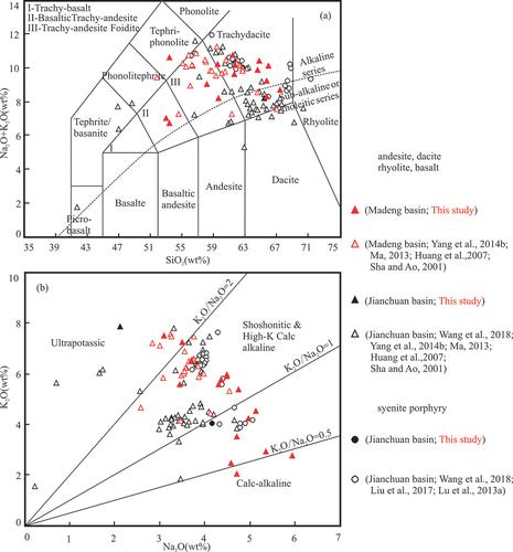
The offset of geological bodies provides robust evidence of displacement along a fault or ductile shear zone. The amount of displacement along the Xuelongshan–Diancangshan–Ailaoshan structural system, southeastern Tibetan Plateau, is uncertain because of the lack of offset geological markers. This NNW–SSE‐trending system is developed in three isolated metamorphic complexes and interjacent nonmetamorphosed rocks. They are expected to record similar post‐Eocene strain, although their structural patterns should be distinct. Geological mapping in the area between the Xuelongshan and Diancangshan metamorphic complexes has revealed a small Eocene basin, the Madeng Basin, located to the west of the structural system. The sedimentary and volcanic successions of the Madeng Basin are comparable to those of the Jianchuan Basin, which is located to the east of the structural system. Zircon U–Pb geochronological and bulk geochemical data demonstrate that the volcanic rocks of both basins formed during 37–34 Ma and share the same geochemical features. These data suggest that the Madeng and Jianchuan basins previously constituted a single basin, with the distribution of high‐K volcanic rocks in the basins defining an ENE–WSW‐trending volcanic belt that shows a limited dextral offset of ≤20 km across the Xuelongshan–Diancangshan–Ailaoshan structural system. Therefore, the northern segment of the structural system records no evidence of large‐scale lateral movement/displacement. The results suggest that the Indochina block, which is bounded by the Xuelongshan–Diancangshan–Ailaoshan structural system to the east and the Sagaing Fault to the west, has not extruded southward as a whole but rather has been deformed by pervasive crustal shortening.
中文翻译:

青藏高原东南部始新世盆地:沿学龙山-垫仓山-哀牢山构造系统的小偏移量标记
地质体的偏移提供了沿断层或韧性剪切带位移的有力证据。由于缺少偏移的地质标志,沿青藏高原东南部的学龙山-垫仓山-哀牢山构造系统的位移量是不确定的。该NNW – SSE –趋势系统是在三个孤立的变质复合体和相邻的非变质岩中开发的。尽管它们的结构模式应该截然不同,但它们预计会记录相似的始新世应变。在学龙山和电苍山变质复合体之间的区域进行的地质测绘显示,一个小始新世盆地-马登盆地,位于构造系统的西部。马登盆地的沉积和火山演替与剑川盆地相当,位于结构系统的东部。锆石U – Pb的年代学和整体地球化学数据表明,两个盆地的火山岩在37–34 Ma期间形成,并具有相同的地球化学特征。这些数据表明,马登盆地和剑川盆地以前是单个盆地,盆地中的高K火山岩分布定义了ENE-WSW趋势火山岩带,在整个雪龙山盆地中,其右旋偏移有限,≤20 km。电苍山-哀牢山构造体系。因此,结构系统的北段没有记录到大规模横向移动/位移的迹象。结果表明,印度支那地块以东部的雪龙山-电苍山-哀牢山构造体系为边界,以西部的实皆断裂为界,
更新日期:2020-08-30
中文翻译:
青藏高原东南部始新世盆地:沿学龙山-垫仓山-哀牢山构造系统的小偏移量标记
地质体的偏移提供了沿断层或韧性剪切带位移的有力证据。由于缺少偏移的地质标志,沿青藏高原东南部的学龙山-垫仓山-哀牢山构造系统的位移量是不确定的。该NNW – SSE –趋势系统是在三个孤立的变质复合体和相邻的非变质岩中开发的。尽管它们的结构模式应该截然不同,但它们预计会记录相似的始新世应变。在学龙山和电苍山变质复合体之间的区域进行的地质测绘显示,一个小始新世盆地-马登盆地,位于构造系统的西部。马登盆地的沉积和火山演替与剑川盆地相当,位于结构系统的东部。锆石U – Pb的年代学和整体地球化学数据表明,两个盆地的火山岩在37–34 Ma期间形成,并具有相同的地球化学特征。这些数据表明,马登盆地和剑川盆地以前是单个盆地,盆地中的高K火山岩分布定义了ENE-WSW趋势火山岩带,在整个雪龙山盆地中,其右旋偏移有限,≤20 km。电苍山-哀牢山构造体系。因此,结构系统的北段没有记录到大规模横向移动/位移的迹象。结果表明,印度支那地块以东部的雪龙山-电苍山-哀牢山构造体系为边界,以西部的实皆断裂为界,


 京公网安备 11010802027423号