当前位置:
X-MOL 学术
›
Urban Forestry Urban Green.
›
论文详情
Our official English website, www.x-mol.net, welcomes your feedback! (Note: you will need to create a separate account there.)
The potential of geospatial analysis and Bayesian networks to enable i-Tree Eco assessment of existing tree inventories
Urban Forestry & Urban Greening ( IF 6.4 ) Pub Date : 2020-11-01 , DOI: 10.1016/j.ufug.2020.126801 Zofie Cimburova , David N. Barton
Urban Forestry & Urban Greening ( IF 6.4 ) Pub Date : 2020-11-01 , DOI: 10.1016/j.ufug.2020.126801 Zofie Cimburova , David N. Barton
|
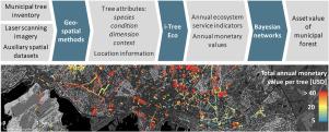
Abstract Valuing the ecosystem services of urban trees is important for gaining public and political support for urban tree conservation and maintenance. The i-Tree Eco software application can be used to estimate regulating ecosystem services provided by urban forests. However, existing municipal tree inventories may not contain data necessary for running i-Tree Eco and manual field surveys are costly and time consuming. Using a tree inventory of Oslo, Norway, as an example, we demonstrate the potential of geospatial and machine learning methods to supplement missing and incomplete i-Tree Eco attributes in existing municipal inventories for the purpose of rapid low-cost urban ecosystem accounting. We correlate manually surveyed stem diameter and crown dimensions derived from airborne laser scanning imagery to complete most structural attributes. We then use auxiliary spatial datasets to derive missing attributes of trees’ spatial context and include differentiation of air pollution levels. The integration of Oslo’s tree inventory with available spatial data increases the proportion of records suitable for i-Tree Eco analysis from 19 % to 54 %. Furthermore, we illustrate how machine learning with Bayesian networks can be used to extrapolate i-Tree Eco outputs and infer the value of the entire municipal inventory. We find the expected total asset value of municipal trees in Oslo to be 38.5–43.4 million USD, depending on different modelling assumptions. We argue that there is a potential for greater use of geospatial methods in compiling information for valuation of urban tree inventories, especially when assessing location-specific tree characteristics, and for more spatially sensitive scaling methods for determining asset values of urban forests for the purpose of awareness-raising. However, given the available data in our case, we question the accuracy of values inferred by Bayesian networks in relation to the purposes of ecosystem accounting and tree compensation valuation.
中文翻译:

地理空间分析和贝叶斯网络在对现有树木库存进行 i-Tree Eco 评估方面的潜力
摘要 评估城市树木的生态系统服务对于获得公众和政治支持对城市树木的保护和维护具有重要意义。i-Tree Eco 软件应用程序可用于估算城市森林提供的调节性生态系统服务。然而,现有的市政树木清单可能不包含运行 i-Tree Eco 所需的数据,手动实地调查既昂贵又耗时。以挪威奥斯陆的树木清单为例,我们展示了地理空间和机器学习方法在现有市政清单中补充缺失和不完整的 i-Tree Eco 属性的潜力,以实现快速低成本的城市生态系统核算。我们将手动测量的茎直径和从机载激光扫描图像得出的牙冠尺寸相关联,以完成大多数结构属性。然后我们使用辅助空间数据集来推导出树木空间背景的缺失属性,并包括空气污染水平的差异。奥斯陆的树木清单与可用空间数据的整合将适合 i-Tree Eco 分析的记录比例从 19% 增加到 54%。此外,我们说明了如何使用贝叶斯网络的机器学习来推断 i-Tree Eco 输出并推断整个市政库存的价值。我们发现奥斯陆市政树木的预期总资产价值为 38.5-4340 万美元,这取决于不同的建模假设。我们认为,有可能更多地使用地理空间方法来编制城市树木清单估价的信息,尤其是在评估特定位置的树木特征时,以及用于确定城市森林资产价值以提高认识的更空间敏感的缩放方法。然而,鉴于我们案例中的可用数据,我们质疑贝叶斯网络推断出的与生态系统核算和树木补偿估值目的相关的值的准确性。
更新日期:2020-11-01
中文翻译:
地理空间分析和贝叶斯网络在对现有树木库存进行 i-Tree Eco 评估方面的潜力
摘要 评估城市树木的生态系统服务对于获得公众和政治支持对城市树木的保护和维护具有重要意义。i-Tree Eco 软件应用程序可用于估算城市森林提供的调节性生态系统服务。然而,现有的市政树木清单可能不包含运行 i-Tree Eco 所需的数据,手动实地调查既昂贵又耗时。以挪威奥斯陆的树木清单为例,我们展示了地理空间和机器学习方法在现有市政清单中补充缺失和不完整的 i-Tree Eco 属性的潜力,以实现快速低成本的城市生态系统核算。我们将手动测量的茎直径和从机载激光扫描图像得出的牙冠尺寸相关联,以完成大多数结构属性。然后我们使用辅助空间数据集来推导出树木空间背景的缺失属性,并包括空气污染水平的差异。奥斯陆的树木清单与可用空间数据的整合将适合 i-Tree Eco 分析的记录比例从 19% 增加到 54%。此外,我们说明了如何使用贝叶斯网络的机器学习来推断 i-Tree Eco 输出并推断整个市政库存的价值。我们发现奥斯陆市政树木的预期总资产价值为 38.5-4340 万美元,这取决于不同的建模假设。我们认为,有可能更多地使用地理空间方法来编制城市树木清单估价的信息,尤其是在评估特定位置的树木特征时,以及用于确定城市森林资产价值以提高认识的更空间敏感的缩放方法。然而,鉴于我们案例中的可用数据,我们质疑贝叶斯网络推断出的与生态系统核算和树木补偿估值目的相关的值的准确性。


 京公网安备 11010802027423号