当前位置:
X-MOL 学术
›
J. Afr. Earth Sci.
›
论文详情
Our official English website, www.x-mol.net, welcomes your
feedback! (Note: you will need to create a separate account there.)
Architectural analysis of an Early Cambrian braided-river system on the north Gondwana margin: The lower sandstone of the Lalun Formation in the Shirgesht area, central Iran
Journal of African Earth Sciences ( IF 2.2 ) Pub Date : 2020-11-01 , DOI: 10.1016/j.jafrearsci.2020.103935 Mehdi Reza Poursoltani
Journal of African Earth Sciences ( IF 2.2 ) Pub Date : 2020-11-01 , DOI: 10.1016/j.jafrearsci.2020.103935 Mehdi Reza Poursoltani
|
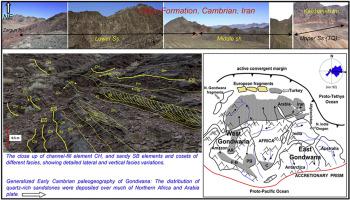
Abstract The Lalun Formation (Early Cimmerian), up to 867 m thick, was studied in the Shirgesht area, Central Iran. It was laid down across the northern edge of Gondwana, where fluvial sandstones were covered by marine shales, carbonates and sandstones. The Lower Sandstone unit of the formation is dominated by sand-rich braided river deposits (97%) with a general scarcity of fine-grained deposits (3%), and the unit consists nine lithofacies (Se, Spb, Sm, Sp, St, Sh, Sr, Fl and Fm). Common sedimentary structures in the succession include planar and trough cross-bedded, plane-laminated and ripple cross-laminated sandstone, and mudcracks in laminated and structureless mudstone. Architectural elements are defined as channel forms and fills (CHs and CHm), sheet sandstone bodies (SB, DA, and LS) and mudstone bodies (FF). The Early Cambrian fluvial system was operating in a non-vegetated setting, and it is probable that the major flooding of the system took place on a seasonal basis. Six orders of surfaces are identified in the outcrops. The highest order surface (sixth-order) includes the lower contact of the Lalun Formation (Lower Sandstone), which was laid down on the Zaigun Formation, and the upper contact of the Lower Sandstone with estuarine deposits of the Middle Shale, denoting a marine transgression. The paleoflow direction is consistent with the reconstructed position of the Lalun Formation during the Cambrian and indicates that sediment was transported eastward to northeastward in the northern part of the Gondwana margin. The petrographic analysis suggests craton interior and transitional continental sources under seasonal humid conditions, consistent with the reconstructed position of Iran along the northeast margin of the Arabian Shield.
中文翻译:

冈瓦纳北部边缘早寒武世辫状河系统的建筑分析:伊朗中部 Shirgesht 地区拉伦组下部砂岩
摘要 在伊朗中部 Shirgesht 地区研究了厚达 867 m 的 Lalun 组(早期 Cimmerian)。它横跨冈瓦纳大陆的北部边缘,在那里河流砂岩被海相页岩、碳酸盐和砂岩覆盖。地层下砂岩单元以富砂辫状河沉积物(97%)为主,细粒沉积物普遍稀缺(3%),该单元由九种岩相(Se、Spb、Sm、Sp、St 、Sh、Sr、Fl 和 Fm)。层序中常见的沉积构造包括平面和槽交错层理、平面层理和波纹交叉层状砂岩,以及层状和无结构泥岩中的泥裂。建筑元素被定义为通道形式和填充物(CHs 和 CHm)、片状砂岩体(SB、DA 和 LS)和泥岩体 (FF)。早寒武纪河流系统在没有植被的环境中运行,系统的大洪水很可能是季节性发生的。在露头中确定了六个级别的表面。最高阶地表(六阶)包括沉积在载根组上的拉伦组(下砂岩)下接触面,以及下砂岩与中页岩河口沉积物的上接触面,表示海相沉积。违法。古流向与寒武纪拉伦组重建位置一致,表明冈瓦纳陆缘北部沉积物向东向东北输送。岩石学分析表明,在季节性潮湿条件下,克拉通内部和过渡大陆源,
更新日期:2020-11-01
中文翻译:
冈瓦纳北部边缘早寒武世辫状河系统的建筑分析:伊朗中部 Shirgesht 地区拉伦组下部砂岩
摘要 在伊朗中部 Shirgesht 地区研究了厚达 867 m 的 Lalun 组(早期 Cimmerian)。它横跨冈瓦纳大陆的北部边缘,在那里河流砂岩被海相页岩、碳酸盐和砂岩覆盖。地层下砂岩单元以富砂辫状河沉积物(97%)为主,细粒沉积物普遍稀缺(3%),该单元由九种岩相(Se、Spb、Sm、Sp、St 、Sh、Sr、Fl 和 Fm)。层序中常见的沉积构造包括平面和槽交错层理、平面层理和波纹交叉层状砂岩,以及层状和无结构泥岩中的泥裂。建筑元素被定义为通道形式和填充物(CHs 和 CHm)、片状砂岩体(SB、DA 和 LS)和泥岩体 (FF)。早寒武纪河流系统在没有植被的环境中运行,系统的大洪水很可能是季节性发生的。在露头中确定了六个级别的表面。最高阶地表(六阶)包括沉积在载根组上的拉伦组(下砂岩)下接触面,以及下砂岩与中页岩河口沉积物的上接触面,表示海相沉积。违法。古流向与寒武纪拉伦组重建位置一致,表明冈瓦纳陆缘北部沉积物向东向东北输送。岩石学分析表明,在季节性潮湿条件下,克拉通内部和过渡大陆源,


 京公网安备 11010802027423号