当前位置:
X-MOL 学术
›
Remote Sens. Ecol. Conserv.
›
论文详情
Our official English website, www.x-mol.net, welcomes your
feedback! (Note: you will need to create a separate account there.)
Classifying wetland‐related land cover types and habitats using fine‐scale lidar metrics derived from country‐wide Airborne Laser Scanning
Remote Sensing in Ecology and Conservation ( IF 3.9 ) Pub Date : 2020-06-09 , DOI: 10.1002/rse2.170 Zsófia Koma 1 , Arie C. Seijmonsbergen 1 , W. Daniel Kissling 1
Remote Sensing in Ecology and Conservation ( IF 3.9 ) Pub Date : 2020-06-09 , DOI: 10.1002/rse2.170 Zsófia Koma 1 , Arie C. Seijmonsbergen 1 , W. Daniel Kissling 1
Affiliation
|
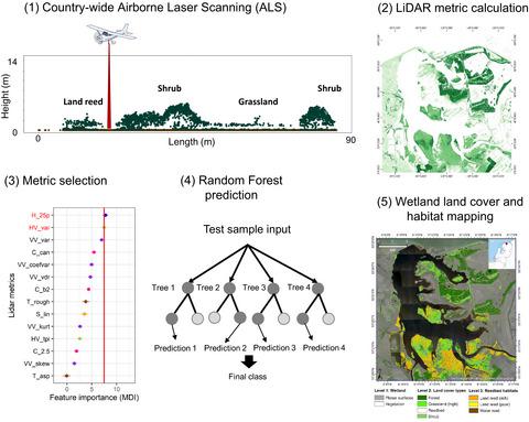
Mapping 3D vegetation structure in wetlands is important for conservation and monitoring. Openly accessible country‐wide Airborne Laser Scanning (ALS) data—using light detection and ranging (lidar) technology—are increasingly becoming available and allow us to quantify 3D vegetation structures at fine resolution and across broad spatial extents. Here, we develop a new, open‐source workflow for classifying wetland‐related land cover types and habitats using fine‐scale lidar metrics derived from country‐wide ALS data. We developed a case study in the Netherlands with a workflow consisting of four routines: (1) pre‐processing of ALS data, (2) calculation of lidar metrics (i.e. 31 features representing cover, 3D shape, vertical variability, horizontal variability and height of vegetation as well as microtopography), (3) assessing feature importance of lidar metrics for classifying wetland habitats, and (4) applying a Random Forest algorithm for mapping and prediction. We used an expert‐based vegetation map for annotation and generated 100, 500 and 1000 annotation points for each class. Using a three‐level hierarchical approach, we differentiated at level 1 planar surfaces (e.g. roads and agricultural fields) from wetland vegetation with 82% mean overall accuracy, using predominantly height and horizontal variability metrics. At level 2, we classified wetland vegetation into four land cover types (forest, grassland, reedbeds, shrubs) with 71% mean overall accuracy, using lidar metrics related to vegetation height and horizontal and vertical variability. At level 3, we differentiated two types of land reed as well as water reed with 78% mean overall accuracy, using predominantly vertical variability metrics. Our results demonstrate that lidar metrics (related to vegetation height, cover, vertical and horizontal variability) derived from country‐wide ALS data can differentiate land cover types and habitats within wetlands at high resolution. Given appropriate annotation data, our workflow can be up‐scaled to a country‐wide extent to allow the comprehensive mapping and monitoring of wetlands at national scales.
中文翻译:

使用源自全国性机载激光扫描的精细激光雷达指标对与湿地有关的土地覆盖类型和栖息地进行分类
在湿地中绘制3D植被结构图对于保护和监测非常重要。使用光检测和测距(激光)技术的可在全国范围内公开获取的机载激光扫描(ALS)数据越来越多,使我们能够在较高分辨率和广泛的空间范围内对3D植被结构进行量化。在这里,我们开发了一个新的开源工作流,该工作流使用从全国范围ALS数据得出的精细激光雷达指标对与湿地有关的土地覆盖类型和栖息地进行分类。我们在荷兰开发了一个案例研究,其工作流程包含四个例程:(1)ALS数据的预处理,(2)激光雷达指标的计算(即代表覆盖物,3D形状,垂直变化,水平变化和高度的31个特征)以及微地形学),(3)评估激光雷达指标的特征重要性,以对湿地生境进行分类,(4)应用随机森林算法进行制图和预测。我们使用了基于专家的植被图进行注释,并为每个类生成了100、500和1000个注释点。使用三级分层方法,我们主要使用高度和水平可变性指标,将1级平面表面(例如道路和农田)与湿地植被区分开,平均总精度为82%。在第2级,我们使用与植被高度以及水平和垂直变化有关的激光雷达指标,将湿地植被分为四种土地覆被类型(森林,草地,芦苇丛,灌木),平均总精度为71%。在第3级,我们区分了两种类型的土地芦苇和水域芦苇,平均总精度为78%,主要使用垂直可变性指标。我们的结果表明,从全国范围的ALS数据得出的激光雷达指标(与植被高度,覆盖率,垂直和水平变化有关)可以在高分辨率下区分湿地内的土地覆盖类型和栖息地。给定适当的注释数据,我们的工作流程可以扩大到全国范围,以允许在国家范围内对湿地进行全面的制图和监测。
更新日期:2020-06-09
中文翻译:
使用源自全国性机载激光扫描的精细激光雷达指标对与湿地有关的土地覆盖类型和栖息地进行分类
在湿地中绘制3D植被结构图对于保护和监测非常重要。使用光检测和测距(激光)技术的可在全国范围内公开获取的机载激光扫描(ALS)数据越来越多,使我们能够在较高分辨率和广泛的空间范围内对3D植被结构进行量化。在这里,我们开发了一个新的开源工作流,该工作流使用从全国范围ALS数据得出的精细激光雷达指标对与湿地有关的土地覆盖类型和栖息地进行分类。我们在荷兰开发了一个案例研究,其工作流程包含四个例程:(1)ALS数据的预处理,(2)激光雷达指标的计算(即代表覆盖物,3D形状,垂直变化,水平变化和高度的31个特征)以及微地形学),(3)评估激光雷达指标的特征重要性,以对湿地生境进行分类,(4)应用随机森林算法进行制图和预测。我们使用了基于专家的植被图进行注释,并为每个类生成了100、500和1000个注释点。使用三级分层方法,我们主要使用高度和水平可变性指标,将1级平面表面(例如道路和农田)与湿地植被区分开,平均总精度为82%。在第2级,我们使用与植被高度以及水平和垂直变化有关的激光雷达指标,将湿地植被分为四种土地覆被类型(森林,草地,芦苇丛,灌木),平均总精度为71%。在第3级,我们区分了两种类型的土地芦苇和水域芦苇,平均总精度为78%,主要使用垂直可变性指标。我们的结果表明,从全国范围的ALS数据得出的激光雷达指标(与植被高度,覆盖率,垂直和水平变化有关)可以在高分辨率下区分湿地内的土地覆盖类型和栖息地。给定适当的注释数据,我们的工作流程可以扩大到全国范围,以允许在国家范围内对湿地进行全面的制图和监测。


 京公网安备 11010802027423号