当前位置:
X-MOL 学术
›
Remote Sens. Ecol. Conserv.
›
论文详情
Our official English website, www.x-mol.net, welcomes your
feedback! (Note: you will need to create a separate account there.)
Influence of altitude on tropical marine habitat classification using imagery from fixed‐wing, water‐landing UAVs
Remote Sensing in Ecology and Conservation ( IF 3.9 ) Pub Date : 2020-05-19 , DOI: 10.1002/rse2.160 Sophia L. Ellis 1, 2 , Michelle L. Taylor 1 , Melissa Schiele 2, 3 , Tom B. Letessier 2
Remote Sensing in Ecology and Conservation ( IF 3.9 ) Pub Date : 2020-05-19 , DOI: 10.1002/rse2.160 Sophia L. Ellis 1, 2 , Michelle L. Taylor 1 , Melissa Schiele 2, 3 , Tom B. Letessier 2
Affiliation
|
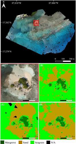
Unmanned aerial vehicles (UAVs) are cost‐effective remote sensing tools useful for generating very high‐resolution (VHR) aerial imagery. Habitat maps generated from UAV imagery are a fundamental component of marine spatial planning, essential for the designation and governance of marine protected areas (MPAs). We investigated whether UAV survey altitude affects habitat classification performance and the classification accuracy of thematic maps from a tropical shallow water environment. We conducted repeated UAV flights at 75, 85, and 110 m, using a fixed‐wing UAV on the Turneffe Atoll, Belize. Flights were ground truthed with snorkel surveys. Images were mosaiced to form orthomosaics and transformed into thematic maps through semi‐automatic object‐based image analysis (OBIA). Three subset areas (4000 m2, 17 000 m2 and 17 000 m2) from two cayes on the atoll were selected to investigate the effect of survey altitude. A linear regression demonstrated that for every 1 m increase in survey altitude, there was a ~1% decrease in the overall classification accuracy. A low survey altitude of 75 m produced a higher classification accuracy for thematic maps and increased the representation of mangrove, seagrass and sand. The variability in classified cover was driven by altitude, although the direction and extent of this relationship was specific to each class. For coral and sea, classified cover decreased with increased altitude. Mangrove classified cover was non‐sensitive to altitude changes, demonstrating a lesser need for a consistent survey altitude. Sand and seagrass had a greater sensitivity to altitude, due to classified cover variability between altitudes. Our findings suggest that survey altitude should be minimized when classifying tropical marine environments (coral, seagrass) and, given that most fixed‐wing UAVs are restricted to a minimum altitude of 70 m, we recommend an altitude of 75 m. Survey altitude should be a major consideration when targeting habitats with greater sensitivity to altitude variability.
中文翻译:

利用固定翼,水着陆无人机的图像,海拔高度对热带海洋栖息地分类的影响
无人机(UAV)是具有成本效益的遥感工具,可用于生成超高分辨率(VHR)的航空影像。从无人机图像生成的栖息地图是海洋空间规划的基本组成部分,对于指定和管理海洋保护区(MPA)至关重要。我们调查了无人机调查高度是否影响生境分类性能以及热带浅水环境中专题图的分类精度。我们在伯利兹Turneffe环礁使用固定翼无人机进行了75、85和110 m的重复无人机飞行。进行浮潜调查,使飞行过程更加真实。通过半自动的基于对象的图像分析(OBIA),将图像拼接成正射马赛克,并转换成专题图。三个子区域(4000 m 2,17000 m 2和17000 m 2从环礁上的两个珊瑚礁中选择),以调查勘测高度的影响。线性回归表明,调查高度每增加1 m,总分类精度就会降低〜1%。75 m的低测量高度为主题地图提供了更高的分类精度,并增加了红树林,海草和沙子的表示。尽管这种关系的方向和程度对于每个类别都是特定的,但分类覆盖率的可变性是由海拔高度决定的。对于珊瑚和海洋,分类覆盖随着海拔的升高而降低。红树林分类覆盖对高度变化不敏感,表明对一致的调查高度的需求较小。由于海拔之间的分类变化,沙和海草对海拔的敏感性更高。我们的发现表明,在对热带海洋环境(珊瑚,海草)进行分类时,应将调查高度降至最低;并且鉴于大多数固定翼无人飞行器的最低高度限制为70 m,我们建议高度为75 m。当以对海拔高度变化更为敏感的栖息地为目标时,调查海拔高度应成为主要考虑因素。
更新日期:2020-05-19
中文翻译:
利用固定翼,水着陆无人机的图像,海拔高度对热带海洋栖息地分类的影响
无人机(UAV)是具有成本效益的遥感工具,可用于生成超高分辨率(VHR)的航空影像。从无人机图像生成的栖息地图是海洋空间规划的基本组成部分,对于指定和管理海洋保护区(MPA)至关重要。我们调查了无人机调查高度是否影响生境分类性能以及热带浅水环境中专题图的分类精度。我们在伯利兹Turneffe环礁使用固定翼无人机进行了75、85和110 m的重复无人机飞行。进行浮潜调查,使飞行过程更加真实。通过半自动的基于对象的图像分析(OBIA),将图像拼接成正射马赛克,并转换成专题图。三个子区域(4000 m 2,17000 m 2和17000 m 2从环礁上的两个珊瑚礁中选择),以调查勘测高度的影响。线性回归表明,调查高度每增加1 m,总分类精度就会降低〜1%。75 m的低测量高度为主题地图提供了更高的分类精度,并增加了红树林,海草和沙子的表示。尽管这种关系的方向和程度对于每个类别都是特定的,但分类覆盖率的可变性是由海拔高度决定的。对于珊瑚和海洋,分类覆盖随着海拔的升高而降低。红树林分类覆盖对高度变化不敏感,表明对一致的调查高度的需求较小。由于海拔之间的分类变化,沙和海草对海拔的敏感性更高。我们的发现表明,在对热带海洋环境(珊瑚,海草)进行分类时,应将调查高度降至最低;并且鉴于大多数固定翼无人飞行器的最低高度限制为70 m,我们建议高度为75 m。当以对海拔高度变化更为敏感的栖息地为目标时,调查海拔高度应成为主要考虑因素。


 京公网安备 11010802027423号