当前位置:
X-MOL 学术
›
Remote Sens. Ecol. Conserv.
›
论文详情
Our official English website, www.x-mol.net, welcomes your
feedback! (Note: you will need to create a separate account there.)
Interplay between topography, fog and vegetation in the central South Arabian mountains revealed using a novel Landsat fog detection technique
Remote Sensing in Ecology and Conservation ( IF 3.9 ) Pub Date : 2020-03-12 , DOI: 10.1002/rse2.151 Lawrence Ball 1 , Joseph Tzanopoulos 2
Remote Sensing in Ecology and Conservation ( IF 3.9 ) Pub Date : 2020-03-12 , DOI: 10.1002/rse2.151 Lawrence Ball 1 , Joseph Tzanopoulos 2
Affiliation
|
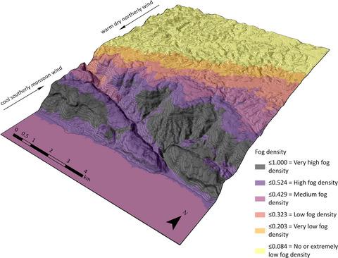
In the central South Arabian mountains of Yemen and Oman, monsoon fog interception by the endemic cloud forest is essential for ecosystem functions and services. Yet, we know little about the local factors affecting fog distributions and their cumulative effects on vegetation. To examine these relationships, we developed a novel method of high‐resolution fog detection using Landsat data, and validated the results using occurrence records of eight moisture‐sensitive plant species. Regression tree analysis was then used to examine the topographic factors influencing fog distributions and the topoclimatic factors influencing satellite‐derived vegetation greenness. We find that the interplay between the complex mountain topography and the incoming fog results in heterogeneous fog densities. Specifically, fog accumulates against steep windward slopes and landforms, resulting in hotspots of fog interception, while lower fog densities occur in leeward locations. We also find that fog distributions correlate with patterns of vegetation greenness, and overall, that greenness increases with fog density. The layer of fog density describes patterns of vegetation greenness more accurately than topographic variables alone, and thus, we propose that regional vegetation patterns more closely follow a fog gradient, than an altitudinal gradient as previously supposed. The layer of fog density will enable an improved understanding of how species and communities, many of which are endemic, range‐restricted and in decline, respond to local variability in topoclimatic conditions.
中文翻译:

使用新型Landsat雾探测技术揭示了南阿拉伯中部山区的地形,雾和植被之间的相互作用
在也门和阿曼的阿拉伯南部中部山区,地方性云雾森林拦截季风雾对生态系统功能和服务至关重要。但是,我们对影响雾气分布的局部因素及其对植被的累积影响知之甚少。为了检查这些关系,我们使用Landsat数据开发了一种高分辨率雾检测的新方法,并使用8种对水分敏感的植物物种的发生记录验证了结果。然后,使用回归树分析来检查影响雾气分布的地形因素和影响人造卫星植被绿色度的地形气候因素。我们发现,复杂的山地地形和传入的雾之间的相互作用导致了雾的密度不均。特别,雾在陡峭的上风坡度和地形上积聚,形成雾的拦截热点,而在下风处则出现较低的雾密度。我们还发现雾的分布与植被的绿色度模式相关,总体而言,绿色度随着雾度的增加而增加。雾密度层比单独的地形变量更准确地描述了植被的绿色度模式,因此,我们建议区域植被模式与雾梯度的关系要比先前假定的高度梯度更紧密。雾的密度层将使人们更好地了解物种和群落(其中许多是地方性的,范围受限制的和正在下降的)如何响应地形气候条件下的局部变化。而较低的雾气密度发生在下风向。我们还发现雾的分布与植被的绿色度模式相关,总体而言,绿色度随着雾度的增加而增加。雾密度层比单独的地形变量更准确地描述了植被的绿色度模式,因此,我们建议区域植被模式与雾梯度的关系要比先前假定的高度梯度更紧密。雾的密度层将使人们更好地了解物种和群落(其中许多是地方性的,范围受限的和下降的)如何响应地形气候条件下的局部变化。而较低的雾气密度发生在下风向。我们还发现雾的分布与植被的绿色度模式相关,总体而言,绿色度随着雾度的增加而增加。雾密度层比单独的地形变量更准确地描述了植被的绿色度模式,因此,我们建议区域植被模式与雾梯度的关系要比先前假定的高度梯度更紧密。雾的密度层将使人们更好地了解物种和群落(其中许多是地方性的,范围受限的和下降的)如何响应地形气候条件下的局部变化。雾密度层比单独的地形变量更准确地描述了植被的绿色度模式,因此,我们建议区域植被模式与雾梯度的关系要比先前假定的高度梯度更紧密。雾的密度层将使人们更好地了解物种和群落(其中许多是地方性的,范围受限的和下降的)如何响应地形气候条件下的局部变化。雾密度层比单独的地形变量更准确地描述了植被的绿色度模式,因此,我们建议区域植被模式与雾梯度的关系要比先前假定的高度梯度更紧密。雾的密度层将使人们更好地了解物种和群落(其中许多是地方性的,范围受限的和下降的)如何响应地形气候条件下的局部变化。
更新日期:2020-03-12
中文翻译:
使用新型Landsat雾探测技术揭示了南阿拉伯中部山区的地形,雾和植被之间的相互作用
在也门和阿曼的阿拉伯南部中部山区,地方性云雾森林拦截季风雾对生态系统功能和服务至关重要。但是,我们对影响雾气分布的局部因素及其对植被的累积影响知之甚少。为了检查这些关系,我们使用Landsat数据开发了一种高分辨率雾检测的新方法,并使用8种对水分敏感的植物物种的发生记录验证了结果。然后,使用回归树分析来检查影响雾气分布的地形因素和影响人造卫星植被绿色度的地形气候因素。我们发现,复杂的山地地形和传入的雾之间的相互作用导致了雾的密度不均。特别,雾在陡峭的上风坡度和地形上积聚,形成雾的拦截热点,而在下风处则出现较低的雾密度。我们还发现雾的分布与植被的绿色度模式相关,总体而言,绿色度随着雾度的增加而增加。雾密度层比单独的地形变量更准确地描述了植被的绿色度模式,因此,我们建议区域植被模式与雾梯度的关系要比先前假定的高度梯度更紧密。雾的密度层将使人们更好地了解物种和群落(其中许多是地方性的,范围受限制的和正在下降的)如何响应地形气候条件下的局部变化。而较低的雾气密度发生在下风向。我们还发现雾的分布与植被的绿色度模式相关,总体而言,绿色度随着雾度的增加而增加。雾密度层比单独的地形变量更准确地描述了植被的绿色度模式,因此,我们建议区域植被模式与雾梯度的关系要比先前假定的高度梯度更紧密。雾的密度层将使人们更好地了解物种和群落(其中许多是地方性的,范围受限的和下降的)如何响应地形气候条件下的局部变化。而较低的雾气密度发生在下风向。我们还发现雾的分布与植被的绿色度模式相关,总体而言,绿色度随着雾度的增加而增加。雾密度层比单独的地形变量更准确地描述了植被的绿色度模式,因此,我们建议区域植被模式与雾梯度的关系要比先前假定的高度梯度更紧密。雾的密度层将使人们更好地了解物种和群落(其中许多是地方性的,范围受限的和下降的)如何响应地形气候条件下的局部变化。雾密度层比单独的地形变量更准确地描述了植被的绿色度模式,因此,我们建议区域植被模式与雾梯度的关系要比先前假定的高度梯度更紧密。雾的密度层将使人们更好地了解物种和群落(其中许多是地方性的,范围受限的和下降的)如何响应地形气候条件下的局部变化。雾密度层比单独的地形变量更准确地描述了植被的绿色度模式,因此,我们建议区域植被模式与雾梯度的关系要比先前假定的高度梯度更紧密。雾的密度层将使人们更好地了解物种和群落(其中许多是地方性的,范围受限的和下降的)如何响应地形气候条件下的局部变化。


 京公网安备 11010802027423号