当前位置:
X-MOL 学术
›
Remote Sens. Ecol. Conserv.
›
论文详情
Our official English website, www.x-mol.net, welcomes your feedback! (Note: you will need to create a separate account there.)
Marmots from space: assessing population size and habitat use of a burrowing mammal using publicly available satellite images
Remote Sensing in Ecology and Conservation ( IF 5.5 ) Pub Date : 2019-12-16 , DOI: 10.1002/rse2.138 Alyona Koshkina 1, 2 , Irina Grigoryeva 2, 3 , Viktor Tokarsky 4 , Ruslan Urazaliyev 1, 2 , Tobias Kuemmerle 5, 6 , Norbert Hölzel 1 , Johannes Kamp 1
Remote Sensing in Ecology and Conservation ( IF 5.5 ) Pub Date : 2019-12-16 , DOI: 10.1002/rse2.138 Alyona Koshkina 1, 2 , Irina Grigoryeva 2, 3 , Viktor Tokarsky 4 , Ruslan Urazaliyev 1, 2 , Tobias Kuemmerle 5, 6 , Norbert Hölzel 1 , Johannes Kamp 1
Affiliation
|
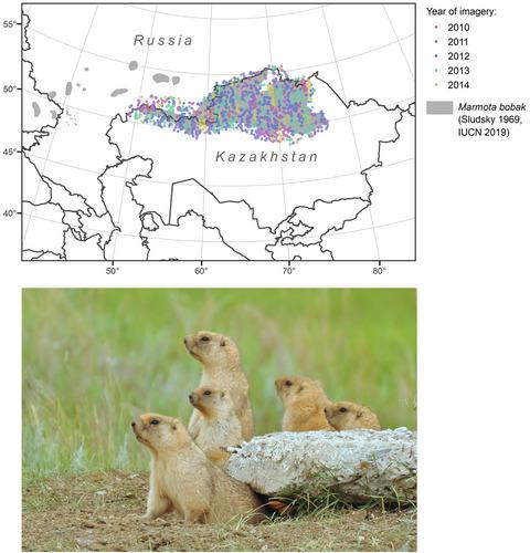
Social, burrowing mammals such as prairie dogs, ground squirrels or marmots are keystone species in grassland ecosystems. Grasslands have been converted into cropland or pastures globally, yet it remains virtually unknown how this has affected the biogeography of burrowing mammals, as efficient, broad‐scale survey methods are lacking. We aimed to test whether structures created by burrowing rodents can be reliably detected on publicly available, very‐high‐resolution satellite images, in order to assess rodent distribution and abundance. We identified burrows of Bobak marmot (Marmota bobak), a keystone burrowing steppe rodent, on 1300 randomly selected plots of 1 km diameter (78.53 ha) across the species’ range (~950 000 km²) in Kazakhstan and southern Russia using Google Earth and Bing images. We then used burrow occurrences and species distribution models to map marmot distribution. We assessed how marmot occurrence and density vary across land‐use types. We also combined satellite‐based burrow densities and ground‐survey data to derive a new population estimate for the species across Kazakhstan. We mapped a total of 7425 burrows from the satellite imagery. Field visits at a subsample of burrows suggested that burrow occurrence was detected reliably. Broad‐scale marmot distribution was mainly determined by summer rainfall, land use and elevation. Occurrence probability was highest on arable croplands, followed by abandoned croplands and grazed steppe. The current Bobak marmot population size for Kazakhstan was estimated at 6.1 (±2.4) million individuals. Our results demonstrate that publicly available, very‐high‐resolution images can be used to reliably map the distribution of burrowing mammals across large geographic scales. The observed and predicted distributions indicate that the Bobak's range has remained almost unchanged in Kazakhstan since the 1950s, despite several drastic episode of land‐use change. This suggests that burrowing mammals can be remarkably resilient to land‐use pressure, questioning prevailing narratives of population collapse in these species following agricultural expansion.
中文翻译:

太空中的土拨鼠:使用可公开获得的卫星图像评估穴居哺乳动物的种群规模和栖息地利用
草原土拨鼠,地松鼠或土拨鼠等社交,穴居哺乳动物是草原生态系统中的重要物种。草原已经在全球范围内转变为农田或牧场,但是,由于缺乏有效,大规模的调查方法,这实际上如何影响洞穴哺乳动物的生物地理学仍然未知。我们旨在测试在可公开获得的超高分辨率卫星图像上是否可以可靠地检测出啮齿类动物挖穴所形成的结构,以便评估啮齿类动物的分布和丰度。我们确定了Bobak土拨鼠(Marmota bobak),这是一种基石穴居草原啮齿动物,使用Google Earth和Bing图像在哈萨克斯坦和俄罗斯南部的1300个直径(约950000km²)的物种范围内随机选择,直径1 km(78.53公顷)。然后,我们使用洞穴发生和物种分布模型来绘制土拨鼠分布图。我们评估了土拨鼠在不同土地利用类型中的发生和密度如何变化。我们还结合了基于卫星的洞穴密度和地面调查数据,以得出哈萨克斯坦整个物种的新种群估计数。我们从卫星图像中绘制了总共7425个洞穴。对洞穴的一个子样本进行的实地考察表明,可以可靠地检测到洞穴的发生。土拨鼠的广泛分布主要取决于夏季降雨,土地利用和海拔。耕地的发生概率最高,其次是废弃的农田和放牧的草原。哈萨克斯坦目前的波巴克土拨鼠人口规模估计为610(±2.4)百万人。我们的结果表明,可公开获得的超高分辨率图像可用于可靠地绘制洞穴哺乳动物在大地理范围内的分布图。观测和预测的分布表明,自从1950年代以来,尽管土地使用发生了几次剧烈变化,但波巴克山脉的范围几乎保持不变。这表明,穴居哺乳动物对土地利用压力具有显着的抵抗力,这使人们对农业扩张后这些物种中种群崩溃的主要说法提出质疑。我们的结果表明,可公开获得的超高分辨率图像可用于可靠地绘制洞穴哺乳动物在大地理范围内的分布图。观测和预测的分布表明,自从1950年代以来,尽管土地使用发生了几次剧烈变化,但波巴克山脉的范围几乎保持不变。这表明,穴居哺乳动物对土地利用压力具有显着的抵抗力,这使人们对农业扩张后这些物种中种群崩溃的主要说法提出质疑。我们的结果表明,可公开获得的超高分辨率图像可用于可靠地绘制洞穴哺乳动物在大地理范围内的分布图。观测和预测的分布表明,自从1950年代以来,尽管土地使用发生了几次剧烈变化,但波巴克山脉的范围几乎保持不变。这表明,穴居哺乳动物对土地利用压力具有显着的抵抗力,这使人们对农业扩张后这些物种中种群崩溃的主要说法提出质疑。尽管发生了几次土地用途急剧变化的事件。这表明,穴居哺乳动物对土地利用压力具有显着的抵抗力,这使人们对农业扩张后这些物种中种群崩溃的主要说法提出质疑。尽管发生了几次土地用途急剧变化的事件。这表明,穴居哺乳动物对土地利用压力具有显着的抵抗力,这使人们对农业扩张后这些物种中种群崩溃的主要说法提出质疑。
更新日期:2019-12-16
中文翻译:
太空中的土拨鼠:使用可公开获得的卫星图像评估穴居哺乳动物的种群规模和栖息地利用
草原土拨鼠,地松鼠或土拨鼠等社交,穴居哺乳动物是草原生态系统中的重要物种。草原已经在全球范围内转变为农田或牧场,但是,由于缺乏有效,大规模的调查方法,这实际上如何影响洞穴哺乳动物的生物地理学仍然未知。我们旨在测试在可公开获得的超高分辨率卫星图像上是否可以可靠地检测出啮齿类动物挖穴所形成的结构,以便评估啮齿类动物的分布和丰度。我们确定了Bobak土拨鼠(Marmota bobak),这是一种基石穴居草原啮齿动物,使用Google Earth和Bing图像在哈萨克斯坦和俄罗斯南部的1300个直径(约950000km²)的物种范围内随机选择,直径1 km(78.53公顷)。然后,我们使用洞穴发生和物种分布模型来绘制土拨鼠分布图。我们评估了土拨鼠在不同土地利用类型中的发生和密度如何变化。我们还结合了基于卫星的洞穴密度和地面调查数据,以得出哈萨克斯坦整个物种的新种群估计数。我们从卫星图像中绘制了总共7425个洞穴。对洞穴的一个子样本进行的实地考察表明,可以可靠地检测到洞穴的发生。土拨鼠的广泛分布主要取决于夏季降雨,土地利用和海拔。耕地的发生概率最高,其次是废弃的农田和放牧的草原。哈萨克斯坦目前的波巴克土拨鼠人口规模估计为610(±2.4)百万人。我们的结果表明,可公开获得的超高分辨率图像可用于可靠地绘制洞穴哺乳动物在大地理范围内的分布图。观测和预测的分布表明,自从1950年代以来,尽管土地使用发生了几次剧烈变化,但波巴克山脉的范围几乎保持不变。这表明,穴居哺乳动物对土地利用压力具有显着的抵抗力,这使人们对农业扩张后这些物种中种群崩溃的主要说法提出质疑。我们的结果表明,可公开获得的超高分辨率图像可用于可靠地绘制洞穴哺乳动物在大地理范围内的分布图。观测和预测的分布表明,自从1950年代以来,尽管土地使用发生了几次剧烈变化,但波巴克山脉的范围几乎保持不变。这表明,穴居哺乳动物对土地利用压力具有显着的抵抗力,这使人们对农业扩张后这些物种中种群崩溃的主要说法提出质疑。我们的结果表明,可公开获得的超高分辨率图像可用于可靠地绘制洞穴哺乳动物在大地理范围内的分布图。观测和预测的分布表明,自从1950年代以来,尽管土地使用发生了几次剧烈变化,但波巴克山脉的范围几乎保持不变。这表明,穴居哺乳动物对土地利用压力具有显着的抵抗力,这使人们对农业扩张后这些物种中种群崩溃的主要说法提出质疑。尽管发生了几次土地用途急剧变化的事件。这表明,穴居哺乳动物对土地利用压力具有显着的抵抗力,这使人们对农业扩张后这些物种中种群崩溃的主要说法提出质疑。尽管发生了几次土地用途急剧变化的事件。这表明,穴居哺乳动物对土地利用压力具有显着的抵抗力,这使人们对农业扩张后这些物种中种群崩溃的主要说法提出质疑。


 京公网安备 11010802027423号