当前位置:
X-MOL 学术
›
Acta Geol. Sinica Engl. Ed.
›
论文详情
Our official English website, www.x-mol.net, welcomes your
feedback! (Note: you will need to create a separate account there.)
A Seismic Hazard Map Based on Geology and Shear-wave Velocity in Rawalpindi–Islamabad, Pakistan
Acta Geologica Sinica-English Edition ( IF 3.5 ) Pub Date : 2020-02-06 , DOI: 10.1111/1755-6724.14405 Sarfraz KHAN 1 , Muhammad WASEEM 1 , M. Asif KHAN 2
Acta Geologica Sinica-English Edition ( IF 3.5 ) Pub Date : 2020-02-06 , DOI: 10.1111/1755-6724.14405 Sarfraz KHAN 1 , Muhammad WASEEM 1 , M. Asif KHAN 2
Affiliation
|
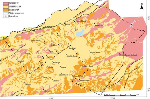
The ‘twin cities’ district of Rawalpindi–Islamabad is among the most endangered seismic regions in Pakistan, with the seismic hazard assessed (0.32 g) to intensity IX MMI for a 475-year return period. A seismic hazard map for Rawalpindi–Islamabad is presented herein, based on 85 shear-wave velocity (VS) profiles obtained through geophysical H/V measurements and from the geological map of the region. Relationships between the average top thirty-meter shear-wave velocities (VS30) and surficial geological units have been determined. The peak ground acceleration (PGA) maps for 150, 475 and 2475-year return periods were converted into a seismic intensity map. Intensity increments for different soils were used to compute PGA values for 150, 475 and 2475-year return periods. Sites located on softer ground experienced a higher degree of damage from moderate earthquakes. Due to the presence of soft clay or liquefiable soil and lateral spreading, a few locations may be classified as hybrid sites class C and D. This map is a critical step in facilitating code-based site classification and seismic design throughout Rawalpindi–Islamabad. Although the seismic hazard map based on seismic intensities is no longer used in engineering geology, it is still important in seismological analysis and for civil protection purposes.
中文翻译:

巴基斯坦拉瓦尔品第-伊斯兰堡基于地质和剪切波速度的地震危险图
拉瓦尔品第-伊斯兰堡的“双城”地区是巴基斯坦最危险的地震地区之一,其地震危险性(0.32克)被评估为IX MMI强度,为期475年。本文根据通过地球物理H / V测量和该地区地质图获得的85个横波速度(V S)剖面,给出了拉瓦尔品第-伊斯兰堡的地震灾害图。平均最高三十米横波速度之间的关系(V S30)和浅层地质单位已经确定。将150年,475年和2475年回归期的峰值地面加速度(PGA)图转换为地震烈度图。使用不同土壤的强度增量来计算150年,475年和2475年回归期的PGA值。位于软土地上的站点遭受中度地震的破坏程度较高。由于存在软黏土或可液化的土壤以及横向扩散,一些地点可能被归类为C和D类混合地点。此地图是在整个Rawalpindi–Islamabad促进基于代码的地点分类和地震设计的关键步骤。尽管基于地震强度的地震危险图已不再用于工程地质中,但它在地震分析和民防领域中仍然很重要。
更新日期:2020-02-06
中文翻译:
巴基斯坦拉瓦尔品第-伊斯兰堡基于地质和剪切波速度的地震危险图
拉瓦尔品第-伊斯兰堡的“双城”地区是巴基斯坦最危险的地震地区之一,其地震危险性(0.32克)被评估为IX MMI强度,为期475年。本文根据通过地球物理H / V测量和该地区地质图获得的85个横波速度(V S)剖面,给出了拉瓦尔品第-伊斯兰堡的地震灾害图。平均最高三十米横波速度之间的关系(V S30)和浅层地质单位已经确定。将150年,475年和2475年回归期的峰值地面加速度(PGA)图转换为地震烈度图。使用不同土壤的强度增量来计算150年,475年和2475年回归期的PGA值。位于软土地上的站点遭受中度地震的破坏程度较高。由于存在软黏土或可液化的土壤以及横向扩散,一些地点可能被归类为C和D类混合地点。此地图是在整个Rawalpindi–Islamabad促进基于代码的地点分类和地震设计的关键步骤。尽管基于地震强度的地震危险图已不再用于工程地质中,但它在地震分析和民防领域中仍然很重要。


 京公网安备 11010802027423号