当前位置:
X-MOL 学术
›
Meteorol. Appl.
›
论文详情
Our official English website, www.x-mol.net, welcomes your
feedback! (Note: you will need to create a separate account there.)
Linking weather patterns to regional extreme precipitation for highlighting potential flood events in medium‐ to long‐range forecasts
Meteorological Applications ( IF 2.3 ) Pub Date : 2020-07-01 , DOI: 10.1002/met.1931 Doug Richardson 1, 2 , Robert Neal 3 , Rutger Dankers 3, 4 , Ken Mylne 3 , Robert Cowling 5 , Holly Clements 5 , Jonathan Millard 5
Meteorological Applications ( IF 2.3 ) Pub Date : 2020-07-01 , DOI: 10.1002/met.1931 Doug Richardson 1, 2 , Robert Neal 3 , Rutger Dankers 3, 4 , Ken Mylne 3 , Robert Cowling 5 , Holly Clements 5 , Jonathan Millard 5
Affiliation
|
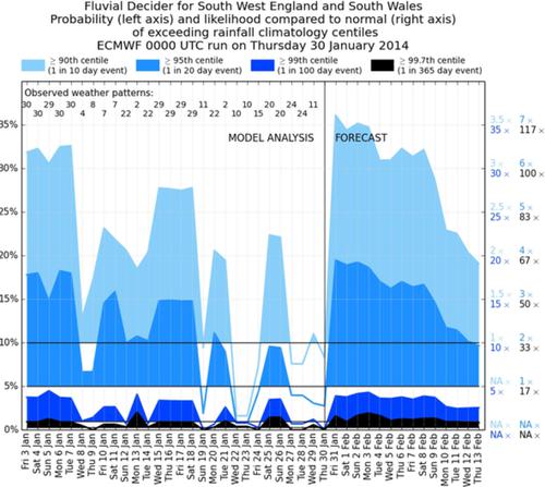
Medium- to long-range precipitation forecasts are a crucial component in mitigating the impacts of fluvial flood events. Although precipitation is difficult to predict at these lead times, the forecast skill of atmospheric circulation tends to be greater. The study explores using weather patterns (WPs) as a preliminary step in producing forecasts of upper-tail precipitation threshold exceedance probabilities for the UK. The WPs are predefined, discrete states representing daily mean sea-level pressure (MSLP) over a European–North Atlantic domain. The WPs most likely to be associated with flooding are highlighted by calculating upper-tail exceedance probabilities derived from the conditional distributions of regional precipitation given each WP. WPs associated with higher probabilities of extreme precipitation are shown to have occurred during two well-known flood events: the 2014 Somerset Levels floods in southwest England; and Storm Desmond over the northern UK in December 2015. To illustrate the potential of this WP-based prediction framework, a forecast guidance tool called Fluvial Decider is introduced. It is intended for use by hydro-meteorologists in the England and Wales Flood Forecasting Centre (FFC). Forecasts of the MSLP from ensemble prediction systems (EPSs) are assigned to the closest-matching WP, providing daily probabilistic forecasts of WPs out to the chosen lead time. Combining these probabilities with observed precipitation threshold exceedance probabilities provides a parsimonious tool for highlighting potential periods with increased risk of flooding. Model forecasts using the European Centre for Medium-range Weather Forecasts (ECMWF) EPS highlighted both flood events as being at a higher than average risk of heavy extreme precipitation at lead times of over five days.
中文翻译:

将天气模式与区域极端降水联系起来,以突出中长期预测中的潜在洪水事件
中长期降水预报是减轻河流洪水事件影响的重要组成部分。虽然在这些提前期降水难以预测,但大气环流的预测技巧往往更高。该研究探索使用天气模式 (WP) 作为预测英国上尾降水阈值超出概率的初步步骤。WP 是预定义的离散状态,代表欧洲-北大西洋区域的每日平均海平面压力 (MSLP)。最有可能与洪水相关的 WP 通过计算从给定每个 WP 的区域降水条件分布得出的上尾超标概率来突出显示。与极端降水概率较高相关的 WP 显示发生在两次著名的洪水事件中:2014 年英格兰西南部的萨默塞特水位洪水;和 2015 年 12 月英国北部的 Storm Desmond。为了说明这种基于 WP 的预测框架的潜力,引入了一种名为 Fluvial Decider 的预测指导工具。它旨在供英格兰和威尔士洪水预报中心 (FFC) 的水文气象学家使用。来自集合预测系统 (EPS) 的 MSLP 预测被分配给最匹配的 WP,提供 WP 到所选提前期的每日概率预测。将这些概率与观测到的降水阈值超过概率相结合,为突出洪水风险增加的潜在时期提供了一种简洁的工具。
更新日期:2020-07-01
中文翻译:
将天气模式与区域极端降水联系起来,以突出中长期预测中的潜在洪水事件
中长期降水预报是减轻河流洪水事件影响的重要组成部分。虽然在这些提前期降水难以预测,但大气环流的预测技巧往往更高。该研究探索使用天气模式 (WP) 作为预测英国上尾降水阈值超出概率的初步步骤。WP 是预定义的离散状态,代表欧洲-北大西洋区域的每日平均海平面压力 (MSLP)。最有可能与洪水相关的 WP 通过计算从给定每个 WP 的区域降水条件分布得出的上尾超标概率来突出显示。与极端降水概率较高相关的 WP 显示发生在两次著名的洪水事件中:2014 年英格兰西南部的萨默塞特水位洪水;和 2015 年 12 月英国北部的 Storm Desmond。为了说明这种基于 WP 的预测框架的潜力,引入了一种名为 Fluvial Decider 的预测指导工具。它旨在供英格兰和威尔士洪水预报中心 (FFC) 的水文气象学家使用。来自集合预测系统 (EPS) 的 MSLP 预测被分配给最匹配的 WP,提供 WP 到所选提前期的每日概率预测。将这些概率与观测到的降水阈值超过概率相结合,为突出洪水风险增加的潜在时期提供了一种简洁的工具。


 京公网安备 11010802027423号