当前位置:
X-MOL 学术
›
Earth Surf.Process. Land.
›
论文详情
Our official English website, www.x-mol.net, welcomes your
feedback! (Note: you will need to create a separate account there.)
A GIS‐based multi‐proxy analysis of the evolution of subglacial dynamics of the Quebec‐Labrador ice dome, northeastern Quebec, Canada
Earth Surface Processes and Landforms ( IF 2.8 ) Pub Date : 2020-08-24 , DOI: 10.1002/esp.4957 J.M. Rice 1 , M. Ross 1 , R.C. Paulen 2 , S.E. Kelley 1, 3 , J.P. Briner 4
Earth Surface Processes and Landforms ( IF 2.8 ) Pub Date : 2020-08-24 , DOI: 10.1002/esp.4957 J.M. Rice 1 , M. Ross 1 , R.C. Paulen 2 , S.E. Kelley 1, 3 , J.P. Briner 4
Affiliation
|
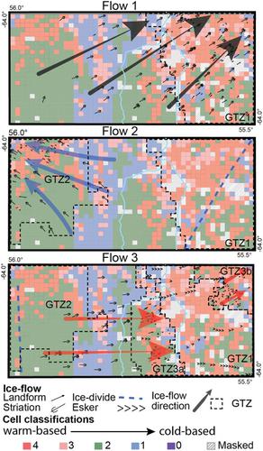
The glacial records of the inner‐core regions of the Laurentide Ice Sheet (LIS) document complex yet coherent patterns reflecting ice‐sheet change (e.g. ice‐divide migration), providing unique insights into past glacial conditions. This study develops a conceptual model of subglacial dynamics evolution within a major ice‐dispersal centre of the LIS in northeastern Quebec, Canada using a GIS‐based analysis of the surficial geologic record. Multiple proxies of subglacial conditions (subglacial streamlined landforms, lake density and lake area over thin drift/bedrock) were analysed through grid‐overlay techniques and then classified based on different proxy variables ranging from highly mobile warm‐based to immobile cold‐based conditions. An additional proxy (till blanket) was used to identify areas of thick till deposition, but with few proxies (few lake or landform metrics). Based on local ice‐flow reconstructions, the most ‘relict’ glacial terrain zone (GTZ1) has warm‐based conditions over 66% of its area and is remarkably well preserved, suggesting laterally extensive warm‐based conditions during the oldest identified ice‐flow phase. This relict glacial terrain is partially overprinted by two subsequent ice‐flow phases in spatially restricted zones in the northeast (73% warm‐ based), east‐central (41%warm‐based), and northwest (33%warm‐based) of the study area. A zone of more sluggish conditions (only 3% warm‐based) was identified in the highlands at the centre of the study area, characterized by thin till cover, few landforms, yet with large patches of relatively abundant small lakes, indicative of areal scouring. No clear evidence of sustained cold‐based conditions (i.e. high chemical index of alteration values or high Be abundances) was found in the study area. These results suggest that warm‐based conditions (active erosion and/or deposition) were uniformly widespread during the earliest ice‐flow phase, later becoming more spatially restricted with broader sluggish ice conditions. These spatially restricted regions of warm‐based subglacial regimes were likely controlled by surrounding and down‐flow ice streaming. © 2020 The Authors. Earth Surface Processes and Landforms published by John Wiley & Sons Ltd
中文翻译:

加拿大魁北克东北部魁北克-拉布拉多冰穹冰下动力学演变的基于 GIS 的多代理分析
劳伦泰德冰盖 (LIS) 内核区域的冰川记录记录了反映冰盖变化(例如冰裂迁移)的复杂而连贯的模式,提供了对过去冰川条件的独特见解。本研究使用基于 GIS 的地表地质记录分析,开发了加拿大魁北克东北部 LIS 主要冰扩散中心内冰下动力学演化的概念模型。通过网格叠加技术分析了冰下条件的多个代理(冰下流线型地貌、湖泊密度和薄层漂移/基岩上的湖泊面积),然后根据不同的代理变量进行分类,范围从高度移动的暖基条件到不动的冷基条件。一个额外的代理(直到毯子)被用来识别厚厚的沉积物区域,但几乎没有代理(很少有湖泊或地形指标)。基于局部冰流重建,最“残存”的冰川地形区(GTZ1)在其面积的 66% 以上具有暖基条件,并且保存得非常完好,表明在最古老的冰流期间横向广泛的暖基条件阶段。这个残存的冰川地形被东北部(73% 暖基)、中东部(41% 暖基)和西北部(33% 暖基)空间限制区的两个后续冰流阶段部分覆盖。研究区。在研究区中心的高地发现了一个条件更加缓慢的区域(只有 3% 的暖基),其特征是覆盖物薄,地貌很少,但有大片相对丰富的小湖泊,表明区域性冲刷. 在研究区没有发现持续寒冷条件的明确证据(即高化学指数变化值或高 Be 丰度)。这些结果表明,暖基条件(活跃的侵蚀和/或沉积)在最早的冰流阶段均匀分布,后来随着更广泛的缓慢冰条件在空间上受到更多限制。这些基于温暖的冰下区域的空间受限区域可能受周围和向下流动的冰流控制。© 2020 作者。John Wiley & Sons Ltd 出版的地球表面过程和地貌 后来随着更广泛的冰冷条件变得更加空间受限。这些基于温暖的冰下区域的空间受限区域可能受周围和向下流动的冰流控制。© 2020 作者。John Wiley & Sons Ltd 出版的地球表面过程和地貌 后来随着更广泛的冰冷条件变得更加空间受限。这些基于温暖的冰下区域的空间受限区域可能受周围和向下流动的冰流控制。© 2020 作者。John Wiley & Sons Ltd 出版的地球表面过程和地貌
更新日期:2020-08-24
中文翻译:
加拿大魁北克东北部魁北克-拉布拉多冰穹冰下动力学演变的基于 GIS 的多代理分析
劳伦泰德冰盖 (LIS) 内核区域的冰川记录记录了反映冰盖变化(例如冰裂迁移)的复杂而连贯的模式,提供了对过去冰川条件的独特见解。本研究使用基于 GIS 的地表地质记录分析,开发了加拿大魁北克东北部 LIS 主要冰扩散中心内冰下动力学演化的概念模型。通过网格叠加技术分析了冰下条件的多个代理(冰下流线型地貌、湖泊密度和薄层漂移/基岩上的湖泊面积),然后根据不同的代理变量进行分类,范围从高度移动的暖基条件到不动的冷基条件。一个额外的代理(直到毯子)被用来识别厚厚的沉积物区域,但几乎没有代理(很少有湖泊或地形指标)。基于局部冰流重建,最“残存”的冰川地形区(GTZ1)在其面积的 66% 以上具有暖基条件,并且保存得非常完好,表明在最古老的冰流期间横向广泛的暖基条件阶段。这个残存的冰川地形被东北部(73% 暖基)、中东部(41% 暖基)和西北部(33% 暖基)空间限制区的两个后续冰流阶段部分覆盖。研究区。在研究区中心的高地发现了一个条件更加缓慢的区域(只有 3% 的暖基),其特征是覆盖物薄,地貌很少,但有大片相对丰富的小湖泊,表明区域性冲刷. 在研究区没有发现持续寒冷条件的明确证据(即高化学指数变化值或高 Be 丰度)。这些结果表明,暖基条件(活跃的侵蚀和/或沉积)在最早的冰流阶段均匀分布,后来随着更广泛的缓慢冰条件在空间上受到更多限制。这些基于温暖的冰下区域的空间受限区域可能受周围和向下流动的冰流控制。© 2020 作者。John Wiley & Sons Ltd 出版的地球表面过程和地貌 后来随着更广泛的冰冷条件变得更加空间受限。这些基于温暖的冰下区域的空间受限区域可能受周围和向下流动的冰流控制。© 2020 作者。John Wiley & Sons Ltd 出版的地球表面过程和地貌 后来随着更广泛的冰冷条件变得更加空间受限。这些基于温暖的冰下区域的空间受限区域可能受周围和向下流动的冰流控制。© 2020 作者。John Wiley & Sons Ltd 出版的地球表面过程和地貌


 京公网安备 11010802027423号