当前位置:
X-MOL 学术
›
Earth Surf.Process. Land.
›
论文详情
Our official English website, www.x-mol.net, welcomes your
feedback! (Note: you will need to create a separate account there.)
Rill network development on loessial hillslopes in China
Earth Surface Processes and Landforms ( IF 2.8 ) Pub Date : 2020-07-16 , DOI: 10.1002/esp.4958 Haiou Shen 1, 2 , Fenli Zheng 1 , Xunchang John Zhang 3 , Chao Qin 1
Earth Surface Processes and Landforms ( IF 2.8 ) Pub Date : 2020-07-16 , DOI: 10.1002/esp.4958 Haiou Shen 1, 2 , Fenli Zheng 1 , Xunchang John Zhang 3 , Chao Qin 1
Affiliation
|
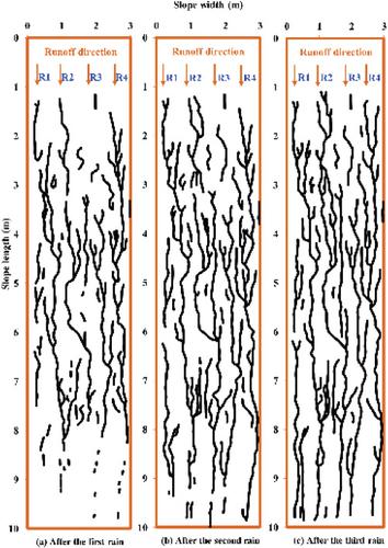
Rill network development not only potentially affects hillslope and drainage network evolution, but also causes severe soil degradation. However, the studies on rill network development remain inconclusive. This study aimed to investigate the temporal and spatial development of hillslope rill networks and their characteristics based on rainfall simulations and field observations. A soil pan (10.0 m long × 3.0 m wide × 0.5 m deep) on a 20° slope was applied three successive simulated rains at two intensities of 50 and 100 mm h–1. The field observations were performed on two bare hillslope runoff plots (10.0 m long × 3.0 m wide) at 20°. Three typical erosive natural rainfall events were observed in the field, and rills were measured in detail, similar to the laboratory rainfall simulation. The results indicated that with increases in rainfall events, the rill network morphology varied from incipient formation to the maximum drainage network density. Four rill network development indicators (rill distribution density, distance between rills, rill bifurcation number, and confluence point number) exhibited different changes over time and space. Among the four indicators, the rill bifurcation number was the best indicator for describing rill network development. Rill flow energy increased and decreased cyclically on a slope ranging between ~3 and 4 m. Moreover, rill networks on loessial hillslopes generally evolved into dendritic rather than parallel forms. The development characteristics of the rill network were relatively similar between the laboratory simulation and natural field conditions. Over time, rill erosion control measures become increasingly difficult to implement as the rill network develops. The morphology of eroding rills evolved over time and space, which led to corresponding rill network development. Further study should quantify the impacts of rill network development on soil degradation and land development. © 2020 John Wiley & Sons, Ltd.
更新日期:2020-07-16


 京公网安备 11010802027423号