当前位置:
X-MOL 学术
›
J. Hydrol.
›
论文详情
Our official English website, www.x-mol.net, welcomes your
feedback! (Note: you will need to create a separate account there.)
Geomorphological impacts of a glacier lake outburst flood in the high arctic Zackenberg River, NE Greenland
Journal of Hydrology ( IF 5.9 ) Pub Date : 2020-12-01 , DOI: 10.1016/j.jhydrol.2020.125300 Aleksandra M. Tomczyk , Marek W. Ewertowski , Jonathan L. Carrivick
Journal of Hydrology ( IF 5.9 ) Pub Date : 2020-12-01 , DOI: 10.1016/j.jhydrol.2020.125300 Aleksandra M. Tomczyk , Marek W. Ewertowski , Jonathan L. Carrivick
|
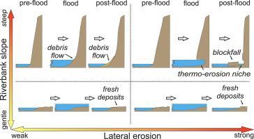
Abstract Glacier lake outburst floods (GLOFs), especially those in the Arctic, can deliver exceptionally high volumes of sediment and solutes to fjords and shallow-marine settings, in comparison to typical seasonal river flows. These sediments and solutes strongly affect coastal geomorphology and aquatic ecosystems, yet are rarely observed. In this study, we have quantified the short-term geomorphological response of the most distal part of the Zackenberg River (northeast Greenland), where it enters Young Sund, to a glacier lake outburst flood that occurred on August 6th 2017. The main aims were to: (1) quantify riverbank and floodplain geomorphology changes that occurred as a consequence of the flood; (2) analyse the spatial patterns of those geomorphological changes and suggest the key controls on them. We used a time-series of very high-resolution UAV-generated images taken on the 5th, 6th, and 8th of August 2017, which enabled us to compare pre- and post-flood fluvial geomorphology. The GLOF induced intense and widespread geomorphological changes, which was surprising because several floods of a similar magnitude have occurred along this river. Approximately 30% of the area of interest experienced changes that were larger than the minimum level of detection (0.15 m). Lateral erosion reached almost 10 m in some places. The total volume loss from bank erosion was at least 26,561 m3 (+/− 14%), whereas the deposition was at least 7745 m3 (+/− 39%). Such an intensive geomorphological response resulted from a combination of factors; namely: (1) bank geometry; (2) composition of bank material; (3) time of occurrence of the event; (4) presence of permafrost; (6) channel geometry; and (7) multitude and diversity of geomorphological processes. We speculate the severity of the geomorphological impact relative to that from previous floods could have been due to warming air temperatures that provided sediment from thawed permafrost, and to an aggrading delta that raised the river base level. Overall, we contend that climate warming will not only make outburst floods from glaciers more likely but that those floods will achieve more geomorphological work with mechanical erosion of permafrost. Erosion and gravitational failures during future flood events will perhaps become even more widespread and intense.
中文翻译:

格陵兰东北部高北极扎肯伯格河冰川湖溃决洪水的地貌影响
摘要 与典型的季节性河流流量相比,冰川湖溃决洪水 (GLOF),尤其是北极发生的洪水,可以向峡湾和浅海环境输送异常大量的沉积物和溶质。这些沉积物和溶质强烈影响沿海地貌和水生生态系统,但很少被观察到。在这项研究中,我们量化了扎肯伯格河最远端(格陵兰岛东北部)进入 Young Sund 对 2017 年 8 月 6 日发生的冰川湖溃决洪水的短期地貌响应。主要目标是以: (1) 量化因洪水而发生的河岸和漫滩地貌变化;(2) 分析这些地貌变化的空间格局并提出关键控制措施。我们使用了 2017 年 8 月 5 日、6 日和 8 日拍摄的超高分辨率无人机生成图像的时间序列,这使我们能够比较洪水前和洪水后的河流地貌。GLOF 引起了强烈而广泛的地貌变化,这是令人惊讶的,因为沿着这条河发生了几次类似规模的洪水。大约 30% 的感兴趣区域经历了大于最低检测水平 (0.15 m) 的变化。一些地方的侧蚀达到近 10 m。堤岸侵蚀造成的总体积损失至少为 26,561 立方米(+/- 14%),而沉积物至少为 7745 立方米(+/- 39%)。如此强烈的地貌反应是多种因素共同作用的结果;即: (1) 堤岸几何;(2) 银行资料的构成;(三)事件发生时间;(4) 永久冻土的存在;(6) 通道几何形状;(7) 地貌过程的多样性和多样性。我们推测,相对于先前洪水造成的地貌影响的严重程度可能是由于气温升高导致融化的永久冻土层产生沉积物,以及三角洲不断增加导致河底水位升高。总的来说,我们认为气候变暖不仅会使冰川爆发洪水的可能性更大,而且这些洪水将通过永久冻土的机械侵蚀实现更多的地貌工作。未来洪水事件中的侵蚀和重力失效可能会变得更加普遍和强烈。我们推测,相对于先前洪水造成的地貌影响的严重程度可能是由于气温升高导致融化的永久冻土层产生沉积物,以及三角洲不断增加导致河底水位升高。总的来说,我们认为气候变暖不仅会使冰川爆发洪水的可能性更大,而且这些洪水将通过永久冻土的机械侵蚀实现更多的地貌工作。未来洪水事件中的侵蚀和重力失效可能会变得更加普遍和强烈。我们推测,相对于先前洪水造成的地貌影响的严重程度可能是由于气温升高导致融化的永久冻土层产生沉积物,以及三角洲不断增加导致河底水位升高。总的来说,我们认为气候变暖不仅会使冰川爆发洪水的可能性更大,而且这些洪水将通过永久冻土的机械侵蚀实现更多的地貌工作。未来洪水事件中的侵蚀和重力失效可能会变得更加普遍和强烈。我们认为,气候变暖不仅会使冰川爆发洪水的可能性更大,而且这些洪水将通过永久冻土的机械侵蚀实现更多的地貌工作。未来洪水事件中的侵蚀和重力失效可能会变得更加普遍和强烈。我们认为,气候变暖不仅会使冰川爆发洪水的可能性更大,而且这些洪水将通过永久冻土的机械侵蚀实现更多的地貌工作。未来洪水事件中的侵蚀和重力失效可能会变得更加普遍和强烈。
更新日期:2020-12-01
中文翻译:
格陵兰东北部高北极扎肯伯格河冰川湖溃决洪水的地貌影响
摘要 与典型的季节性河流流量相比,冰川湖溃决洪水 (GLOF),尤其是北极发生的洪水,可以向峡湾和浅海环境输送异常大量的沉积物和溶质。这些沉积物和溶质强烈影响沿海地貌和水生生态系统,但很少被观察到。在这项研究中,我们量化了扎肯伯格河最远端(格陵兰岛东北部)进入 Young Sund 对 2017 年 8 月 6 日发生的冰川湖溃决洪水的短期地貌响应。主要目标是以: (1) 量化因洪水而发生的河岸和漫滩地貌变化;(2) 分析这些地貌变化的空间格局并提出关键控制措施。我们使用了 2017 年 8 月 5 日、6 日和 8 日拍摄的超高分辨率无人机生成图像的时间序列,这使我们能够比较洪水前和洪水后的河流地貌。GLOF 引起了强烈而广泛的地貌变化,这是令人惊讶的,因为沿着这条河发生了几次类似规模的洪水。大约 30% 的感兴趣区域经历了大于最低检测水平 (0.15 m) 的变化。一些地方的侧蚀达到近 10 m。堤岸侵蚀造成的总体积损失至少为 26,561 立方米(+/- 14%),而沉积物至少为 7745 立方米(+/- 39%)。如此强烈的地貌反应是多种因素共同作用的结果;即: (1) 堤岸几何;(2) 银行资料的构成;(三)事件发生时间;(4) 永久冻土的存在;(6) 通道几何形状;(7) 地貌过程的多样性和多样性。我们推测,相对于先前洪水造成的地貌影响的严重程度可能是由于气温升高导致融化的永久冻土层产生沉积物,以及三角洲不断增加导致河底水位升高。总的来说,我们认为气候变暖不仅会使冰川爆发洪水的可能性更大,而且这些洪水将通过永久冻土的机械侵蚀实现更多的地貌工作。未来洪水事件中的侵蚀和重力失效可能会变得更加普遍和强烈。我们推测,相对于先前洪水造成的地貌影响的严重程度可能是由于气温升高导致融化的永久冻土层产生沉积物,以及三角洲不断增加导致河底水位升高。总的来说,我们认为气候变暖不仅会使冰川爆发洪水的可能性更大,而且这些洪水将通过永久冻土的机械侵蚀实现更多的地貌工作。未来洪水事件中的侵蚀和重力失效可能会变得更加普遍和强烈。我们推测,相对于先前洪水造成的地貌影响的严重程度可能是由于气温升高导致融化的永久冻土层产生沉积物,以及三角洲不断增加导致河底水位升高。总的来说,我们认为气候变暖不仅会使冰川爆发洪水的可能性更大,而且这些洪水将通过永久冻土的机械侵蚀实现更多的地貌工作。未来洪水事件中的侵蚀和重力失效可能会变得更加普遍和强烈。我们认为,气候变暖不仅会使冰川爆发洪水的可能性更大,而且这些洪水将通过永久冻土的机械侵蚀实现更多的地貌工作。未来洪水事件中的侵蚀和重力失效可能会变得更加普遍和强烈。我们认为,气候变暖不仅会使冰川爆发洪水的可能性更大,而且这些洪水将通过永久冻土的机械侵蚀实现更多的地貌工作。未来洪水事件中的侵蚀和重力失效可能会变得更加普遍和强烈。


 京公网安备 11010802027423号