Estuarine, Coastal and Shelf Science ( IF 2.6 ) Pub Date : 2020-07-14 , DOI: 10.1016/j.ecss.2020.106897 Satoshi Asaoka , Satoshi Nakada , Akira Umehara , Joji Ishizaka , Wataru Nishijima
|
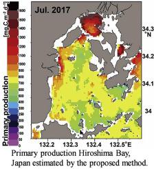
Ocean primary production measured by conventional methods using carbon isotope are mostly calculated from point sampling, which is not appropriate for estimating the temporal and spatial variations involved in marine ecosystems. Ocean color remote sensing can estimate spatial variation of ocean primary production at the global scale. However, the spatial resolution of the ocean color remote sensing is not adequate for estimating coastal ocean primary production. This study sought to establish a novel methodology for estimating coastal ocean primary production in Hiroshima Bay, Japan using high-resolution ocean color data (~500 m) and higher temporal resolution (hourly during the day) obtained by a geostationary ocean color satellite, GOCI-COMS. Estimated values of primary production derived from the ocean color satellite based on the Kameda & Ishizaka model did not correlate with observed primary production. We estimated primary production in Hiroshima Bay with a modified Kameda & Ishizaka model. The coefficient of determination between observed and estimated primary production by the ocean color satellite was 0.750. The slope of the linear regression was 1.00, and root mean square error was 165 mg-C m2 d−1. Our proposed method was thus sufficient for discussions of the changes in spatial distribution of primary production in Hiroshima Bay. Finally, spatial distribution of primary production in Hiroshima Bay was estimated using our proposed method. In January, the primary production of the Hiroshima Bay ranged <50-1000 mg-C m−2 d−1, and increased to 1000–1600< mg-C m−2 d−1 during seasonal blooms in spring and autumn. The primary production was relatively high at the innermost and western parts of the bay which affected by terrigeneous loads compared to other parts of the bay. In July 2016, highest primary production was observed at the innermost of the bay, ranging from 1200 to 1600< mg-C m−2 d−1. The high primary production was considered to be due to the supply of nutrients from terrigeneous load. Hence, our proposed method based on the high-resolution (approx. 500 m) ocean-color product has been enabled us to estimate primary production in coastal seas including complicated topographic areas such as enclosed seas or channels of less than 1 km wide.
中文翻译:
利用对地静止海洋彩色卫星估算日本广岛湾沿海海洋初级产品的空间分布
用碳同位素通过常规方法测得的海洋初级生产大部分是通过点采样计算得出的,这不适用于估算海洋生态系统所涉及的时空变化。海洋颜色遥感可以估计全球范围内海洋初级生产的空间变化。但是,海洋颜色遥感的空间分辨率不足以估算沿海海洋的初级生产力。这项研究试图建立一种新颖的方法,用于估计日本广岛湾沿岸的初级海洋产量,该方法利用对地静止海洋彩色卫星GOCI获得的高分辨率海洋颜色数据(〜500 m)和更高的时间分辨率(白天每小时) -COMS。根据Kameda和 石坂模型与观察到的初级生产没有关联。我们使用改良的Kameda&Ishizaka模型估算了广岛湾的主要产量。海洋彩色卫星观测到的与估计的一次生产之间的确定系数为0.750。线性回归的斜率为1.00,均方根误差为165 mg-C m2 d -1。因此,我们提出的方法足以讨论广岛湾初级生产的空间分布变化。最后,使用我们提出的方法估算了广岛湾一次生产的空间分布。一月份,广岛湾的初级产量在<50-1000 mg-C m -2 d -1范围内,并在春季和秋季的季节性开花期间增加到1000-1600 <mg-C m -2 d -1。与海湾其他部分相比,该海湾最内层和西部的主要产量相对较高,受陆源负荷的影响。2016年7月,在海湾的最内层观察到最高的初级产量,范围从1200至1600 <mg-C m-2 d -1。初级产量高被认为是由于来自陆源负载的养分供应。因此,我们基于高分辨率(约500 m)海洋颜色产品的拟议方法使我们能够估算沿海海域的初级产量,这些沿海海域包括复杂的地形区域,例如封闭海域或宽度不足1 km的河道。


 京公网安备 11010802027423号