当前位置:
X-MOL 学术
›
Earth Surf.Process. Land.
›
论文详情
Our official English website, www.x-mol.net, welcomes your
feedback! (Note: you will need to create a separate account there.)
Dynamic flood topographies in the Terai region of Nepal
Earth Surface Processes and Landforms ( IF 2.8 ) Pub Date : 2020-07-13 , DOI: 10.1002/esp.4953 E.H. Dingle 1, 2 , M.J. Creed 2 , H.D. Sinclair 2 , D. Gautam 3 , N. Gourmelen 2 , A.G.L. Borthwick 4 , M. Attal 2
Earth Surface Processes and Landforms ( IF 2.8 ) Pub Date : 2020-07-13 , DOI: 10.1002/esp.4953 E.H. Dingle 1, 2 , M.J. Creed 2 , H.D. Sinclair 2 , D. Gautam 3 , N. Gourmelen 2 , A.G.L. Borthwick 4 , M. Attal 2
Affiliation
|
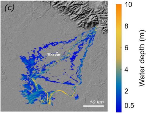
Flood hazard maps used to inform and build resilience in remote communities in the Terai region of southern Nepal are based on outdated and static digital elevation models (DEMs), which do not reflect dynamic river configuration or hydrology. Episodic changes in river course, sediment dynamics, and the distribution of flow down large bifurcation nodes can modify the extent of flooding in this region, but these processes are rarely considered in flood hazard assessment. Here, we develop a 2D hydrodynamic flood model of the Karnali River in the Terai region of west Nepal. A number of scenarios are tested examining different DEMs, variable bed elevations to simulate bed aggradation and incision, and updating bed elevations at a large bifurcation node to reflect field observations. By changing the age of the DEM used in the model, a 9.5% increase in inundation extent was observed for a 20‐year flood discharge. Reducing horizontal DEM resolution alone resulted in a <1% change. Uniformly varying the bed elevation led to a 36% change in inundation extent. Finally, changes in bed elevation at the main bifurcation to reflect observed conditions resulted in the diversion of the majority of flow into the west branch, consistent with measured discharge ratios between the two branches, and a 32% change in inundation extent. Although the total flood inundation area was reduced (−4%), there was increased inundation along the west bank. Our results suggest that regular field measurements of bed elevation and updated DEMs following large sediment‐generating events, and at topographically sensitive areas such as large river bifurcations, could help improve model inputs in future flood prediction models. This is particularly important following flood events carrying large sediment loads out of mountainous regions that could promote bed aggradation and channel switching across densely populated alluvial river systems and floodplains further downstream. © 2020 The Authors. Earth Surface Processes and Landforms published by John Wiley & Sons Ltd
中文翻译:

尼泊尔Terai地区的动态洪水地形
用来在尼泊尔南部Terai地区的偏远社区提供信息和增强抗灾能力的洪水灾害图是基于过时的和静态的数字高程模型(DEM),不能反映动态的河流配置或水文状况。河道的周期性变化,沉积物动力学以及沿大型分叉节点的水流分布可以改变该地区的洪灾程度,但是在洪水灾害评估中很少考虑这些过程。在这里,我们开发了尼泊尔西部特莱地区卡纳利河的二维水力洪水模型。测试了许多场景,检查了不同的DEM,可变的床高以模拟床的凝结和切开,并更新了大分叉节点处的床高以反映现场观察。通过更改模型中使用的DEM的年龄,可以得到9。20年的洪水排放发现淹没程度增加了5%。仅降低水平DEM分辨率会导致<1%的变化。床高度的均匀变化导致淹没程度发生36%的变化。最后,为了反映观察到的条件,主分叉处的床高变化导致大部分流量转移到西分支,这与两个分支之间测得的流量比一致,淹没程度变化了32%。尽管洪水泛滥的总面积减少了(-4%),但西岸的洪水泛滥了。我们的结果表明,在发生大型沉积物事件之后,以及在地形敏感区域(例如大型河流分叉处),定期对床高和更新的DEM进行现场测量,可以帮助改善未来洪水预测模型中的模型输入。在洪水事件将大量的泥沙带出山区之后,这尤其重要,这可能会促进河床积聚,并在人口稠密的冲积河流系统和下游的洪泛区之间切换河道。©2020作者。约翰·威利父子有限公司出版的《地球表面过程和地形》
更新日期:2020-07-13
中文翻译:
尼泊尔Terai地区的动态洪水地形
用来在尼泊尔南部Terai地区的偏远社区提供信息和增强抗灾能力的洪水灾害图是基于过时的和静态的数字高程模型(DEM),不能反映动态的河流配置或水文状况。河道的周期性变化,沉积物动力学以及沿大型分叉节点的水流分布可以改变该地区的洪灾程度,但是在洪水灾害评估中很少考虑这些过程。在这里,我们开发了尼泊尔西部特莱地区卡纳利河的二维水力洪水模型。测试了许多场景,检查了不同的DEM,可变的床高以模拟床的凝结和切开,并更新了大分叉节点处的床高以反映现场观察。通过更改模型中使用的DEM的年龄,可以得到9。20年的洪水排放发现淹没程度增加了5%。仅降低水平DEM分辨率会导致<1%的变化。床高度的均匀变化导致淹没程度发生36%的变化。最后,为了反映观察到的条件,主分叉处的床高变化导致大部分流量转移到西分支,这与两个分支之间测得的流量比一致,淹没程度变化了32%。尽管洪水泛滥的总面积减少了(-4%),但西岸的洪水泛滥了。我们的结果表明,在发生大型沉积物事件之后,以及在地形敏感区域(例如大型河流分叉处),定期对床高和更新的DEM进行现场测量,可以帮助改善未来洪水预测模型中的模型输入。在洪水事件将大量的泥沙带出山区之后,这尤其重要,这可能会促进河床积聚,并在人口稠密的冲积河流系统和下游的洪泛区之间切换河道。©2020作者。约翰·威利父子有限公司出版的《地球表面过程和地形》


 京公网安备 11010802027423号