当前位置:
X-MOL 学术
›
Remote Sens. Environ.
›
论文详情
Our official English website, www.x-mol.net, welcomes your
feedback! (Note: you will need to create a separate account there.)
Using NASA Earth observations and Google Earth Engine to map winter cover crop conservation performance in the Chesapeake Bay watershed
Remote Sensing of Environment ( IF 11.1 ) Pub Date : 2020-10-01 , DOI: 10.1016/j.rse.2020.111943 Alison Thieme , Sunita Yadav , Perry C. Oddo , John M. Fitz , Sean McCartney , LeeAnn King , Jason Keppler , Gregory W. McCarty , W. Dean Hively
Remote Sensing of Environment ( IF 11.1 ) Pub Date : 2020-10-01 , DOI: 10.1016/j.rse.2020.111943 Alison Thieme , Sunita Yadav , Perry C. Oddo , John M. Fitz , Sean McCartney , LeeAnn King , Jason Keppler , Gregory W. McCarty , W. Dean Hively
|
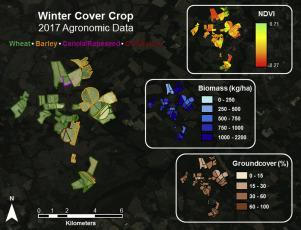
Abstract Winter cover crops such as barley, rye, and wheat help to improve soil structure by increasing porosity, aggregate stability, and organic matter, while reducing the loss of agricultural nutrients and sediments into waterways. The environmental performance of cover crops is affected by choice of species, planting date, planting method, nutrient inputs, temperature, and precipitation. The Maryland Department of Agriculture (MDA) oversees an agricultural cost-share program that provides farmers with funding to cover costs associated with planting winter cover crops, and the U.S. Geological Survey (USGS) and the U.S. Department of Agriculture-Agricultural Research Service (USDA-ARS) have partnered with the MDA to develop satellite remote sensing techniques for measuring cover crop performance. The MDA has developed the capacity to digitize field boundaries for all fields enrolled in their cover crop programs (>26,000 fields per year) to support a remote sensing performance analysis at a statewide scal,e and has requested assistance with the associated imagery processing from the National Aeronautics and Space Administration (NASA). Using the Google Earth Engine (GEE) cloud computing platform, scripts were developed to process Landsat 5/7/8 and Harmonized Sentinel-2 imagery to measure winter cover crop performance. We calibrated cover crop performance models using linear regression between satellite vegetation indices and USGS / USDA-ARS field sampling data collected on Maryland farms between 2006 and 2012 (1298 samples). Satellite-derived Normalized Difference Vegetation Index (NDVI) values showed significant correlation with the natural logarithm of cover crop biomass (p ≤0.01, R2 = 0.56) and with observed percent vegetative ground cover (p ≤0.01, R2 = 0.68). The GEE scripts were used to composite seasonal maximum NDVI values for each enrolled cover crop field and calculate performance metrics for the winter and spring seasons of three enrollment years (2014–15, 2015–16, and 2017–18) for four Maryland counties. Results from winter 2017–18 demonstrate that rye and barley fields had higher biomass than wheat fields, and that early planting, along with planting methods that increase seed-soil contact, increased performance. The processing capabilities of GEE will support the MDA in scaling up remote sensing performance analysis statewide, providing information to evaluate the environmental outcomes associated with various agronomic management strategies. The tool can be modified for different seasonal cutoffs, utilize new sensors to capture phenology in winter and spring, and scale to larger regions for use in adaptive management of winter cover crops planted for environmental benefit. Project support This project was supported by the USGS Land Change Science Program within the Land Resources Mission Area, the USDA Choptank River Conservation Effects Assessment Project (CEAP), the USDA Lower Chesapeake Bay Long Term Agricultural Research (LTAR) Project; the Maryland Department of Agriculture; and the NASA DEVELOP National Program.
中文翻译:

使用 NASA 地球观测和谷歌地球引擎绘制切萨皮克湾流域冬季覆盖作物保护性能图
摘要 大麦、黑麦和小麦等冬季覆盖作物有助于通过增加孔隙度、团聚体稳定性和有机质来改善土壤结构,同时减少农业养分和沉积物进入水道的损失。覆盖作物的环境绩效受物种选择、种植日期、种植方法、养分投入、温度和降水的影响。马里兰州农业部 (MDA) 负责监督一项农业成本分摊计划,该计划为农民提供资金以支付与种植冬季覆盖作物相关的费用,以及美国地质调查局 (USGS) 和美国农业部农业研究服务局 (USDA) -ARS) 与 MDA 合作开发卫星遥感技术,用于测量覆盖作物的性能。MDA 已开发出将所有参加其覆盖作物计划的田地(每年超过 26,000 个田地)的田地边界数字化的能力,以支持全州范围内的遥感性能分析,并已请求相关图像处理方面的协助美国国家航空航天局 (NASA)。使用谷歌地球引擎 (GEE) 云计算平台,开发了脚本来处理 Landsat 5/7/8 和 Harmonized Sentinel-2 图像,以测量冬季覆盖作物的性能。我们使用卫星植被指数与 2006 年至 2012 年间在马里兰州农场收集的 USGS/USDA-ARS 现场采样数据(1298 个样本)之间的线性回归校准覆盖作物性能模型。卫星衍生的归一化差异植被指数 (NDVI) 值显示与覆盖作物生物量的自然对数 (p ≤0.01, R2 = 0.56) 和观察到的植物地被植物百分比 (p ≤0.01, R2 = 0.68) 显着相关。GEE 脚本用于合成每个注册覆盖作物田的季节性最大 NDVI 值,并计算马里兰州四个县的三个注册年(2014-15、2015-16 和 2017-18)的冬季和春季的绩效指标。2017-18 年冬季的结果表明,黑麦和大麦田的生物量高于小麦田,并且早期种植以及增加种子与土壤接触的种植方法提高了性能。GEE 的处理能力将支持 MDA 在全州范围内扩大遥感性能分析,提供信息以评估与各种农艺管理策略相关的环境结果。该工具可以针对不同的季节性截止点进行修改,利用新传感器来捕捉冬季和春季的物候,并扩展到更大的区域,用于对为环境效益种植的冬季覆盖作物进行适应性管理。项目支持 该项目得到了美国地质调查局土地资源任务区内的土地变化科学计划、美国农业部乔普坦克河保护效果评估项目 (CEAP)、美国农业部下切萨皮克湾长期农业研究 (LTAR) 项目的支持;马里兰州农业部;和 NASA DEVELOP 国家计划。利用新传感器捕捉冬季和春季的物候,并扩展到更大的区域,用于对为环境效益种植的冬季覆盖作物进行适应性管理。项目支持 该项目得到了美国地质调查局土地资源任务区内的土地变化科学计划、美国农业部乔普坦克河保护效果评估项目 (CEAP)、美国农业部下切萨皮克湾长期农业研究 (LTAR) 项目的支持;马里兰州农业部;和 NASA DEVELOP 国家计划。利用新传感器捕捉冬季和春季的物候,并扩展到更大的区域,用于对为环境效益种植的冬季覆盖作物进行适应性管理。项目支持 该项目得到了美国地质调查局土地资源任务区内的土地变化科学计划、美国农业部乔普坦克河保护效果评估项目 (CEAP)、美国农业部下切萨皮克湾长期农业研究 (LTAR) 项目的支持;马里兰州农业部;和 NASA DEVELOP 国家计划。美国农业部乔普坦克河保护效果评估项目 (CEAP)、美国农业部下切萨皮克湾长期农业研究 (LTAR) 项目;马里兰州农业部;和 NASA DEVELOP 国家计划。美国农业部乔普坦克河保护效果评估项目 (CEAP)、美国农业部下切萨皮克湾长期农业研究 (LTAR) 项目;马里兰州农业部;和 NASA DEVELOP 国家计划。
更新日期:2020-10-01
中文翻译:
使用 NASA 地球观测和谷歌地球引擎绘制切萨皮克湾流域冬季覆盖作物保护性能图
摘要 大麦、黑麦和小麦等冬季覆盖作物有助于通过增加孔隙度、团聚体稳定性和有机质来改善土壤结构,同时减少农业养分和沉积物进入水道的损失。覆盖作物的环境绩效受物种选择、种植日期、种植方法、养分投入、温度和降水的影响。马里兰州农业部 (MDA) 负责监督一项农业成本分摊计划,该计划为农民提供资金以支付与种植冬季覆盖作物相关的费用,以及美国地质调查局 (USGS) 和美国农业部农业研究服务局 (USDA) -ARS) 与 MDA 合作开发卫星遥感技术,用于测量覆盖作物的性能。MDA 已开发出将所有参加其覆盖作物计划的田地(每年超过 26,000 个田地)的田地边界数字化的能力,以支持全州范围内的遥感性能分析,并已请求相关图像处理方面的协助美国国家航空航天局 (NASA)。使用谷歌地球引擎 (GEE) 云计算平台,开发了脚本来处理 Landsat 5/7/8 和 Harmonized Sentinel-2 图像,以测量冬季覆盖作物的性能。我们使用卫星植被指数与 2006 年至 2012 年间在马里兰州农场收集的 USGS/USDA-ARS 现场采样数据(1298 个样本)之间的线性回归校准覆盖作物性能模型。卫星衍生的归一化差异植被指数 (NDVI) 值显示与覆盖作物生物量的自然对数 (p ≤0.01, R2 = 0.56) 和观察到的植物地被植物百分比 (p ≤0.01, R2 = 0.68) 显着相关。GEE 脚本用于合成每个注册覆盖作物田的季节性最大 NDVI 值,并计算马里兰州四个县的三个注册年(2014-15、2015-16 和 2017-18)的冬季和春季的绩效指标。2017-18 年冬季的结果表明,黑麦和大麦田的生物量高于小麦田,并且早期种植以及增加种子与土壤接触的种植方法提高了性能。GEE 的处理能力将支持 MDA 在全州范围内扩大遥感性能分析,提供信息以评估与各种农艺管理策略相关的环境结果。该工具可以针对不同的季节性截止点进行修改,利用新传感器来捕捉冬季和春季的物候,并扩展到更大的区域,用于对为环境效益种植的冬季覆盖作物进行适应性管理。项目支持 该项目得到了美国地质调查局土地资源任务区内的土地变化科学计划、美国农业部乔普坦克河保护效果评估项目 (CEAP)、美国农业部下切萨皮克湾长期农业研究 (LTAR) 项目的支持;马里兰州农业部;和 NASA DEVELOP 国家计划。利用新传感器捕捉冬季和春季的物候,并扩展到更大的区域,用于对为环境效益种植的冬季覆盖作物进行适应性管理。项目支持 该项目得到了美国地质调查局土地资源任务区内的土地变化科学计划、美国农业部乔普坦克河保护效果评估项目 (CEAP)、美国农业部下切萨皮克湾长期农业研究 (LTAR) 项目的支持;马里兰州农业部;和 NASA DEVELOP 国家计划。利用新传感器捕捉冬季和春季的物候,并扩展到更大的区域,用于对为环境效益种植的冬季覆盖作物进行适应性管理。项目支持 该项目得到了美国地质调查局土地资源任务区内的土地变化科学计划、美国农业部乔普坦克河保护效果评估项目 (CEAP)、美国农业部下切萨皮克湾长期农业研究 (LTAR) 项目的支持;马里兰州农业部;和 NASA DEVELOP 国家计划。美国农业部乔普坦克河保护效果评估项目 (CEAP)、美国农业部下切萨皮克湾长期农业研究 (LTAR) 项目;马里兰州农业部;和 NASA DEVELOP 国家计划。美国农业部乔普坦克河保护效果评估项目 (CEAP)、美国农业部下切萨皮克湾长期农业研究 (LTAR) 项目;马里兰州农业部;和 NASA DEVELOP 国家计划。


 京公网安备 11010802027423号